Hello! Welcome to the first lesson of Module 2.
In the previous module, we laid the essential groundwork for our design. You learned how to analyze a site plan, group plants with similar water needs, and divide the landscape into distinct hydrozones. You then calculated the precise area (m²) for each of those zones. We now have the "where" (the zones) and the "how big" (the area).
This lesson begins the process of calculating how much water each zone needs. To do that, we must first understand the primary driver of water loss in any landscape: the weather. Our learning outcome for today is to define Reference Evapotranspiration (ET₀) and its role in irrigation planning. This value serves as the universal, climate-driven baseline for all professional irrigation calculations.
1. Evaporation and Transpiration: The Two Components of Water Loss
Before we can define reference evapotranspiration, we need to understand the core concept. The total water lost from a landscape to the atmosphere is called Evapotranspiration (ET). As the name suggests, it's a combination of two separate processes:
- Evaporation: Water lost directly from the soil surface and water bodies.
- Transpiration: Water taken up by plant roots and released as vapor from their leaves, stems, and flowers.
Evapotranspiration and Precipitation Data for Calculating ...
To start, let's get a clear definition of these terms from this fact sheet by the Utah State University Extension.
Read the short section titled 'Evaporation and Transpiration.' It clearly distinguishes between the two processes that make up total evapotranspiration (ETa).
The rate of this combined water loss is influenced by several weather factors: solar radiation (sunshine), temperature, humidity, and wind speed. A hot, dry, windy day will have a much higher ET rate than a cool, still, humid day.
2. Establishing a Benchmark: Reference Evapotranspiration (ET₀)
Every plant has a different transpiration rate, and every site has unique conditions. To create a workable system for irrigation design, we need a standardized starting point—a benchmark to compare everything against. This benchmark is Reference Evapotranspiration (ET₀).
ET₀ represents the amount of water lost by a hypothetical, ideal grass surface under specific conditions. Think of it as a "perfect lawn" that is:
- Completely uniform cool-season grass.
- Actively growing and perfectly healthy.
- Kept at a consistent height (typically 8-15 cm).
- Completely shading the ground.
- Never short of water.
This concept is visualized very effectively in the diagram below.
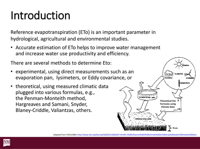
This idealized measurement gives us a single, powerful number for any given location and day. It answers the question: "Under today's weather conditions, what is the maximum possible water loss from a perfect grass surface?"
To refine this definition, let's look at how two different professional bodies describe it.
WaterSense® Water Budget Approach
The EPA's WaterSense program and the Food and Agriculture Organization (FAO) provide very clear, practical definitions of ET₀. Reading them will solidify your understanding of this concept.
First, find the heading 'Explanation of Calculations' and read the first two paragraphs under the subheading 'Baseline'. This gives a practical description of ET₀. Then, scroll to the glossary at the end and read the formal definition for 'Reference evapotranspiration (grass reference evapotranspiration) (ETo)'.
In summary, ET₀ is a standardized, weather-based value representing the potential rate of water loss from a well-watered, reference grass surface. It is typically expressed in millimeters per day (mm/day).
3. The Role of ET₀ in Irrigation Planning
So, why is this hypothetical number so crucial for a practical field like irrigation design?
The role of ET₀ is to serve as the foundational climatic input for calculating the water needs of any plant. Because it's a standardized value, we can use it as a multiplier. If we know the ET₀ for our project's location, we can then use a plant-specific factor (which we'll cover in the next lesson) to determine the precise water requirement for our lawn, shrubs, or trees.
Here are the key roles ET₀ plays in your design process:
- Provides a Starting Point: It is the universal baseline for calculating water budgets for any landscape.
- Enables Accurate Water-Need Calculation: It allows you to move beyond guesswork and calculate the actual water requirement for each of your hydrozones.
- Prevents Over- or Under-Watering: By designing a system based on ET₀, you ensure the landscape receives the water it needs to be healthy without being wasteful.
- Aids in Water-Efficient Design: It allows you to compare the water use of different design choices. For example, you can calculate the water savings achieved by replacing a high-water-use lawn with a low-water-use shrub bed.
Evapotranspiration and Precipitation Data for Calculating ...
The Utah State University Extension document expands on the vital role ET₀ plays in professional water management.
Read the section titled 'Reference Evapotranspiration and Precipitation Data: Vital Roles in Water Management.' Focus on the bulleted list that outlines how ET₀ values are used in landscape planning and water management.
For your projects, you will not be calculating ET₀ from raw weather data. Instead, you will obtain it from local sources—ministries of agriculture, university extension services, or online climate databases. These sources provide historical average ET₀ values for the hottest, driest month of the year (the "peak month"), which is what we use for design. The complex calculations, like the industry-standard Penman-Monteith equation, have already been done for you.
Test your understanding!
You are tasked with creating preliminary irrigation plans for two identical villa gardens (same size, same plants). One is located in a hot, dry, windy desert climate, and the other is in a cool, humid coastal climate.
- Which location will have a higher ET₀ value during the summer?
- How will this difference in ET₀ affect your final irrigation design in terms of the amount of water the system will need to deliver?
Show answer
-
The desert climate will have a significantly higher ET₀ value. The combination of high temperature, high solar radiation, low humidity, and wind creates a much higher potential for water loss through evapotranspiration.
-
The higher ET₀ in the desert means the plants will lose water more quickly and will require more water to stay healthy. Therefore, the irrigation system for the desert villa will need to be designed to deliver a larger total volume of water each day compared to the identical garden in the cool, coastal climate. This will affect everything from the water source requirements to the pump size and the daily run times of the irrigation zones.
Conclusion
You have now mastered the first, and most fundamental, variable in the plant water requirement equation. Understanding ET₀ moves you from arbitrary watering schedules to a scientific, data-driven approach to irrigation design.
Key Takeaways:
- Evapotranspiration (ET) is the total water lost from the soil (evaporation) and plants (transpiration).
- Reference Evapotranspiration (ET₀) is a standardized benchmark representing the water loss from a "perfect" grass surface, driven purely by weather conditions (sun, temperature, wind, humidity).
- The primary role of ET₀ in irrigation planning is to act as the baseline value from which the actual water needs of any specific plant can be calculated.
- ET₀ is a published value for a given location that you will look up, not calculate yourself.
Next Steps
We've established the weather-driven baseline (ET₀). In the next lesson, we will learn how to adjust this baseline for the specific plants in your hydrozones. We will introduce the Crop Coefficient (Kc) and use the formula ETc = ET₀ × Kc to calculate the actual daily water requirement for your lawns, shrubs, and trees.