Hello! Welcome back to our exploration of the dynamic Earth.
In our last two lessons, we delved into the specifics of earthquakes and volcanoes, understanding them as powerful releases of Earth's internal energy, fundamentally tied to the theory of plate tectonics. We saw how different plate boundaries create the conditions for either seismic events, volcanic eruptions, or both.
Today, we will synthesize that knowledge to achieve our learning outcome: to analyze the global distribution of tectonic hazards such as earthquakes and volcanoes. We will move from the "why" and "how" of individual events to the "where" on a global scale. This lesson will heavily leverage your interest in mapping, as we will use maps to visualize these patterns and see how they provide compelling evidence for plate tectonic theory.
1. The Global Pattern: A Clear Correlation
If you were to plot every significant earthquake and volcanic eruption on a world map, you would immediately notice that their locations are not random. Instead, they form distinct, often overlapping, linear belts that trace paths across the globe.
To see this for yourself, let's explore an interactive story map. This is a powerful tool that allows us to visualize geographic data in layers.
Mapping Volcanoes and Earthquakes
This ArcGIS StoryMap, 'Mapping Volcanoes and Earthquakes', will allow you to discover the global distribution of these hazards firsthand.
Please explore the first three sections of the story map. First, look at the map of volcanoes. Then, look at the map of earthquakes. Observe the patterns. Finally, view the map with the tectonic plate boundaries. Notice the striking correlation between the locations of the hazards and the edges of the plates. The short text accompanying the maps will guide your observations.
As you saw in the story map, the correlation is undeniable. The zones of intense earthquake and volcanic activity are, for the most part, the boundaries of the Earth's tectonic plates.
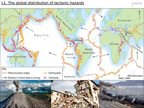
2. The Pacific "Ring of Fire": The World's Most Active Zone
The most prominent and famous of these belts is the Pacific Ring of Fire, an approximately 40,000 km (25,000 mi) long, horseshoe-shaped zone that encircles the Pacific Ocean. This region is home to the vast majority of the world's earthquakes and active volcanoes.
Let's watch a brief video that highlights the significance of this feature.
What Are Volcanoes and How Are They Formed?
This clip from ClickView provides a concise overview of the Ring of Fire, emphasizing its dominance in global volcanic activity.
Watch the segment from 02:47 to 03:25. Pay close attention to the statistics provided about the percentage of active volcanoes and major eruptions located within the Ring of Fire.
Why is this region so active? The Ring of Fire is essentially a continuous series of convergent plate boundaries, where the dense Pacific Plate and other smaller plates are subducting beneath the surrounding continental plates (like the North American, South American, and Eurasian plates).
As we learned in previous lessons:
- Subduction causes powerful earthquakes: The immense friction and stress buildup as one plate grinds beneath another leads to the most powerful earthquakes on the planet.
- Subduction causes explosive volcanism: The process of flux melting in the mantle above the subducting slab generates high-viscosity, gas-rich magma, which feeds the chains of explosive composite volcanoes that line the coasts of the Pacific.
1.10: Tectonic Forces- Quakes and Volcanoes
This text provides a more detailed description of the subduction processes that make the Ring of Fire so active.
Please read the section 'VOLCANOES ALONG CONVERGENT PLATE BOUNDARIES'. It describes how subduction around the Pacific Ocean basin creates both volcanoes and earthquakes, specifically mentioning the different segments of the Ring of Fire along the Americas.
3. Hazard Distribution by Plate Boundary Type
While the Ring of Fire is the most dramatic example, each type of plate boundary has a characteristic signature of tectonic hazards. Let's systematically review the hazards associated with each.
The 4 Tectonic Plate Boundaries and the Hazards they Create
This video from Simple Geography provides an excellent summary of the specific hazards you can expect to find at each of the four main boundary types. It's a great way to consolidate your knowledge.
Watch the entire video from 00:38 to 05:04. As you watch each section (constructive/divergent, destructive/convergent, collision, conservative/transform), focus on the explanation for why certain hazards (volcanoes, strong earthquakes) are present or absent at that boundary type.
To summarize the key points from the video:
- Divergent Boundaries (e.g., Mid-Atlantic Ridge, East African Rift): Characterized by frequent, but generally less powerful, shallow earthquakes and effusive volcanism as magma rises to fill the gap.
- Convergent Boundaries (Subduction) (e.g., Ring of Fire): The most hazardous zones, with frequent, extremely powerful earthquakes (including deep ones) and explosive volcanism.
- Convergent Boundaries (Collision) (e.g., Himalayas): Experience powerful, shallow earthquakes due to crustal compression and mountain building, but no volcanism because there is no subduction to generate magma.
- Transform Boundaries (e.g., San Andreas Fault): Can generate powerful, shallow earthquakes as plates slide past each other, but have no associated volcanic activity.
Test your understanding!
A team of geologists is exploring a remote mountain range. They find evidence of frequent, powerful earthquakes but see no signs of current or past volcanic activity. Which type of plate boundary are they most likely exploring?
Show answer
They are most likely exploring a continental-continental collision boundary. This type of boundary produces intense crustal deformation leading to powerful earthquakes, but lacks the subduction process necessary to generate magma for volcanoes.
4. Beyond the Boundaries: Hotspots and Human Factors
Hotspots: As we learned previously, there are exceptions to the rule. Volcanoes like those in Hawaii or the supervolcano at Yellowstone are located in the middle of tectonic plates. These hotspot volcanoes are caused by stationary mantle plumes and represent a different, more isolated type of volcanic hazard distribution.
Analyzing "Hazard": Finally, it's important to remember that analyzing the distribution of a "hazard" involves more than just geology. The risk to human life and property depends heavily on where people live and how they build. A magnitude 7.0 earthquake in a densely populated city with poor building codes (like Port-au-Prince, Haiti in 2010) is a far greater catastrophe than a magnitude 8.0 in a remote, unpopulated area.
To briefly explore this idea, let's look at the factors that turn a geological event into a human disaster.
1.10: Tectonic Forces- Quakes and Volcanoes
This section from 'Tectonic Forces' discusses the human element of earthquake hazards.
Read the first three paragraphs of the 'DAMAGE FROM EARTHQUAKES' section. Focus on the factors mentioned, such as population density and ground type, that influence the severity of damage.
Conclusion
In this lesson, we have successfully mapped out the global landscape of tectonic hazards. By plotting the locations of earthquakes and volcanoes, we have seen how their distribution provides a powerful visual confirmation of plate tectonic theory.
Key Takeaways:
- The global distribution of earthquakes and volcanoes is not random; they are concentrated in belts that correspond directly with tectonic plate boundaries.
- The Pacific "Ring of Fire" is the world's most active tectonic zone, a result of extensive subduction at convergent plate boundaries.
- Each boundary type has a distinct hazard profile:
- Convergent: High risk of powerful earthquakes and explosive volcanoes.
- Divergent: Moderate risk of weaker earthquakes and effusive volcanoes.
- Transform & Collision: High risk of powerful earthquakes, but no volcanism.
- Hotspots create volcanic hazards within plates, acting as important exceptions to the plate boundary rule.
- The true analysis of a hazard considers not only the geological process but also human factors like population density and infrastructure.
Preview of the Next Lesson:
This lesson concludes our module on the Earth's internal forces and the large-scale structures they build. We will now shift our focus to the forces that shape and sculpt these structures on the surface. We will begin the next module, Geomorphology, by exploring the fundamental processes of weathering—how rock is broken down by physical and chemical means, preparing it to be moved by the forces of erosion.