Hello! Welcome back to our module on the Solid Earth.
In our last lesson, we established that Earth's tectonic plates are in constant motion and interact at three types of boundaries: divergent, convergent, and transform. We saw that these boundaries are hubs of intense geological activity. Today, we will focus on one of the most powerful and often destructive results of this activity: earthquakes.
Our learning outcome is to explain the causes of earthquakes, their measurement (magnitude and intensity), and their relationship to plate boundaries. By the end of this lesson, you will understand the fundamental mechanism that triggers an earthquake, how scientists quantify their size and impact, and why they are predominantly found in specific zones across the globe.
1. What Causes an Earthquake?
Imagine bending a dry stick. You can feel the resistance as you apply pressure and the stick stores that energy by flexing. If you keep bending it, it will eventually snap. The stored energy is released in an instant, creating sound and vibrations. Earthquakes work on a similar principle, but on a planetary scale.
This process is formally known as the Elastic Rebound Theory. It describes how the crustal rocks along a fault behave. As tectonic plates grind past each other, their rough edges get stuck, but the rest of the plates continue to move. This causes the rocks to bend and deform, storing enormous amounts of elastic energy, much like the bending stick. When the accumulated stress finally overcomes the friction holding the rocks together, the rocks slip or "rebound" suddenly, releasing the stored energy in the form of seismic waves. These vibrations are what we feel as an earthquake.
To see this process explained visually, please watch the following video.
What Is The ‘Elastic Rebound Theory’ (ERT)
This video from Earth Science Classroom provides a clear and concise explanation of the Elastic Rebound Theory, tracing its origins to the study of the 1906 San Francisco earthquake.
Watch the video from the beginning to the end (around 7:50). Focus on understanding the sequence of events: stress buildup, rock deformation (strain), sudden fracture and displacement, and the release of energy as seismic waves.
As the video explained, there are a few key terms we use to describe an earthquake's location:
- Fault: A fracture or zone of fractures in the Earth's crust where movement occurs.
- Hypocentre (or Focus): The point within the Earth where the earthquake rupture starts. This is where the energy is first released.
- Epicentre: The point on the Earth's surface directly above the hypocentre. This is the location usually reported in the news.
2. The Link Between Earthquakes and Plate Boundaries
In the last lesson, we saw that plate boundaries are zones of interaction. Now, combining that with the Elastic Rebound Theory, it becomes clear why most earthquakes occur at these boundaries. The constant motion of the plates provides the continuous stress needed to deform rocks and cause faulting.
Let's visualize this global connection.
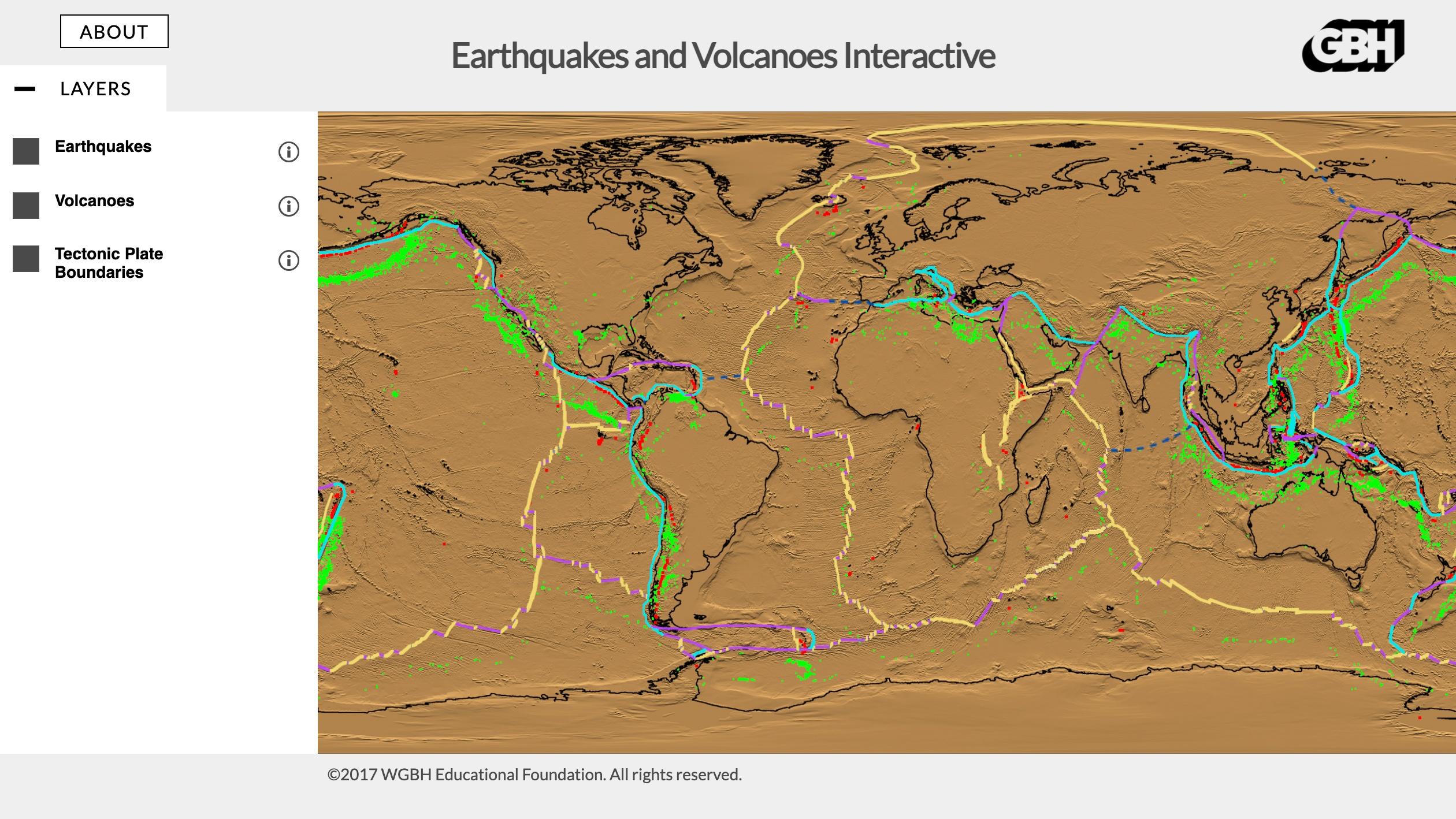
The type of plate boundary influences the characteristics of the earthquakes found there. To understand this relationship in more detail, we'll consult a resource from the National Oceanic and Atmospheric Administration (NOAA).
JetStream Max: Plate Tectonics and Earthquakes
The article 'Plate Tectonics and Earthquakes' from NOAA's JetStream Max service provides an excellent summary of how different plate boundaries relate to different types of faults and earthquakes.
Please read the sections titled 'Plate Boundaries' and 'Faults and Earthquakes'. As you read, make a mental note of which type of fault (reverse, normal, strike-slip) is associated with each type of plate boundary (convergent, divergent, transform).
From your reading, we can summarize the key relationships:
- Convergent Boundaries: As plates collide, immense compressional stress builds up. This leads to reverse (or thrust) faults. When one plate subducts under another, it can get stuck and then release suddenly, generating the world's largest and deepest earthquakes. The "Ring of Fire" around the Pacific Ocean, a zone of intense subduction, is responsible for about 90% of the world's earthquakes.
- Divergent Boundaries: As plates pull apart, tensional stress dominates. This creates normal faults. Earthquakes at these boundaries, like mid-ocean ridges, are frequent but are typically smaller in magnitude and shallower than at convergent boundaries.
- Transform Boundaries: As plates slide past each other, shear stress builds up along strike-slip faults. These faults can get locked for long periods, accumulating significant stress that, when released, can cause major, shallow earthquakes. The San Andreas Fault in California is a classic example.
3. Measuring Earthquakes: Magnitude vs. Intensity
When an earthquake is reported, you often hear a number, like "magnitude 7.1." But you might also hear descriptions of the damage, like "severe shaking" or "buildings collapsed." These refer to two different, though related, ways of measuring an earthquake: magnitude and intensity. It's crucial to understand the difference.

Let's explore these two concepts in more detail using a comprehensive textbook resource.
11.3 Measuring Earthquakes – Physical Geology
This chapter from a physical geology textbook offers a detailed breakdown of how magnitude and intensity are defined and measured.
Please read the entire page. In the 'Earthquake Magnitude' section, focus on understanding that magnitude is a single value related to energy release and that the scale is logarithmic. Note the different types of magnitude scales, especially Moment Magnitude (MW). In the 'Earthquake Intensity' section, understand that intensity varies with location and is described using the Modified Mercalli Intensity Scale. Skim the table to see how different levels of shaking and damage are classified.
Key Points on Magnitude and Intensity
Magnitude:
- What it is: A single number that represents the total amount of energy released by an earthquake at its source (the hypocentre).
- How it's measured: Calculated from seismic waves recorded by seismographs. The modern standard is the Moment Magnitude (MW) scale.
- Key Feature: The scale is logarithmic. This is a critical point. A magnitude 7.0 earthquake releases about 32 times more energy than a magnitude 6.0, and about 1,000 times more energy than a magnitude 5.0. Small increases in the magnitude number represent huge leaps in energy.
Intensity:
- What it is: A measure of the shaking and damage caused by an earthquake at a specific location. It is not a single number for the whole earthquake.
- How it's measured: Assessed by observing the effects on people, buildings, and the environment. It's described using the Modified Mercalli Intensity (MMI) Scale, which uses Roman numerals (I - XII).
- Key Feature: Intensity generally decreases with distance from the epicentre, but it is also heavily influenced by local geology. Soft, unconsolidated sediments can amplify shaking, leading to higher intensity and more damage, even at a greater distance from the earthquake. The 1985 Mexico City example from your reading is a tragic and powerful illustration of this effect.
Test your understanding!
A powerful earthquake strikes off the coast of a continent.
- City A is located 50 km from the epicentre and is built on solid bedrock. It experiences an MMI of VI (Strong).
- City B is located 200 km from the epicentre but is built on soft, water-saturated lake sediments. It experiences an MMI of VIII (Severe), with significant building damage.
- What is the magnitude of the earthquake as felt in City B?
- How can you explain the fact that the more distant city experienced more severe shaking?
Show answer
- This is a trick question. Magnitude is the energy released at the earthquake's source and is a single value for the entire event. It is not something that changes with location. Therefore, the magnitude is the same for City A, City B, and everywhere else.
- The difference in damage is due to intensity. Even though City B is farther away, its foundation on soft, water-saturated sediments amplified the seismic waves. This phenomenon, called liquefaction or site amplification, caused the ground to shake more violently, leading to a higher intensity (MMI VIII) and greater damage compared to City A, which was protected by its stable bedrock foundation (MMI VI).
Conclusion
In this lesson, we have demystified earthquakes, moving from their fundamental cause to their global distribution and measurement. You now have a solid framework for understanding these powerful geological events.
Key Takeaways:
- Earthquakes are caused by the sudden slip along a fault, which releases stored elastic energy in the form of seismic waves, a process described by the Elastic Rebound Theory.
- The vast majority of earthquakes occur at plate boundaries, where the motion of plates builds up the necessary stress. The type of boundary (convergent, divergent, transform) determines the type of faulting and the typical characteristics of the earthquakes.
- Earthquake size is measured in two main ways: Magnitude (e.g., Moment Magnitude), which is a single value representing the total energy released at the source, and Intensity (e.g., Modified Mercalli Intensity), which describes the variable effects of shaking and damage at different locations.
Preview of the Next Lesson:
We've now covered one of the two major hazards associated with plate tectonics. In the next lesson, we will explore the other: volcanism. We will investigate why volcanoes form, the different types of volcanoes and eruptions, and how their locations are also intrinsically linked to the movement of Earth's plates.