Hello! Welcome back to our module on the Solid Earth.
In the last lesson, we traced the revolutionary scientific journey that led to the Theory of Plate Tectonics. We established that Earth's lithospheric plates are in constant motion, driven by processes like seafloor spreading. This discovery fundamentally changed our view of the planet from a static world to a dynamic, ever-evolving system.
Today, we will address the next logical question: what happens at the edges where these moving plates interact? The answer lies at the heart of much of Earth's most dramatic geology. Our learning outcome for this lesson is to describe the three types of plate boundaries (convergent, divergent, and transform) and their associated geologic features. By the end of this lesson, you will understand why mountains rise, volcanoes erupt, and earthquakes shake our planet, and you'll know where to find these zones of intense activity.
1. A World in Motion: The Global Picture
The theory of plate tectonics divides the Earth's lithosphere into about a dozen major plates and several smaller ones. All the action—the creation of mountains, the eruption of volcanoes, and the triggering of earthquakes—is concentrated at the boundaries where these plates meet.
Before we dive into the details, let's look at a map of these plates and their boundaries.
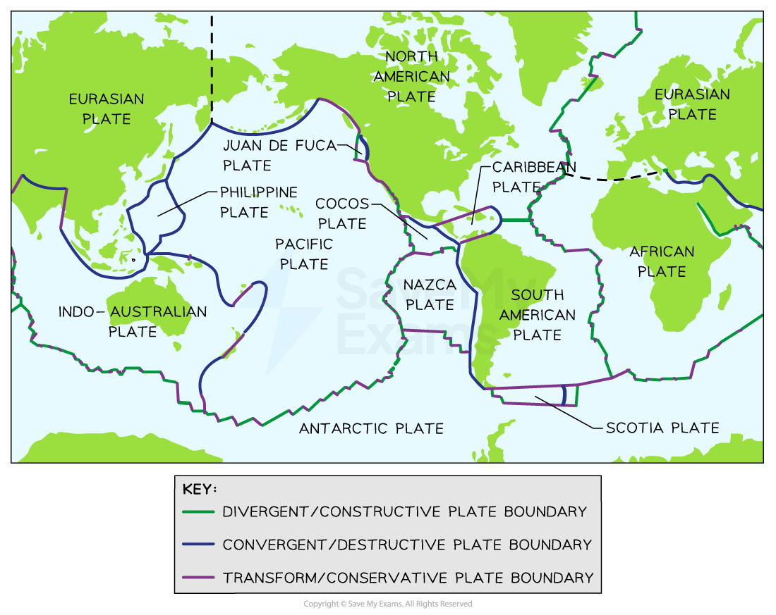
As the map key suggests, geologists classify these interactions into three fundamental types based on the relative motion of the plates.
2. The Three Types of Plate Boundaries
To get a comprehensive overview of these three boundary types, their movements, and the features they create, we'll watch a detailed tutorial video. It uses clear, hand-drawn diagrams to build these concepts from the ground up, which is an excellent way to form a strong mental model.
The video 'Plate Boundary Types' from the Earth Explained channel provides a systematic walkthrough of convergent, divergent, and transform boundaries. It clearly illustrates the motion and resulting geological features for each type.
Please watch the video from the beginning to 17:38. As you watch, focus on associating three key things for each boundary type: The Direction of Motion: Are the plates moving apart, together, or sideways? The Geological Processes: What is happening to the crust (e.g., subduction, rifting, faulting)? The Resulting Features: What landforms or events are created (e.g., mountains, trenches, volcanoes, earthquakes)?
Now that you have a solid visual overview from the video, let's break down each boundary type systematically, reinforcing the concepts with a written resource from the U.S. Geological Survey (USGS).
3. A Deeper Dive into Plate Boundaries
We'll use the authoritative text from the USGS to explore each boundary in more detail. This will help solidify the key terminology and provide additional real-world examples.
Understanding plate motions [This Dynamic Earth, USGS]
The USGS publication 'This Dynamic Earth' offers a clear, text-based explanation of the three main plate boundaries. We will use it as our primary reference as we examine each type.
For now, just have this resource ready. I will guide you to the specific sections to read as we discuss each boundary type below.
a) Divergent Boundaries: Creating New Crust
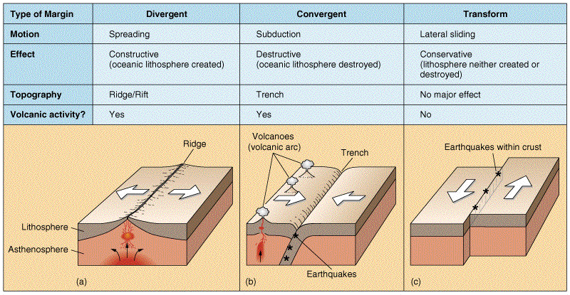
As the name suggests, divergent boundaries are zones where two plates are pulling apart from each other. This is the "constructive" boundary, where new lithosphere is generated.
- Process: As the plates separate, the pressure on the underlying asthenosphere is reduced. This causes decompression melting, and hot magma rises to fill the gap. It cools and solidifies to form new crust.
- On the Ocean Floor: This process is most common underwater, where it forms mid-ocean ridges. These are vast, underwater mountain ranges that extend around the globe, like the Mid-Atlantic Ridge. This is the physical manifestation of the seafloor spreading we discussed in the last lesson. The volcanism is typically gentle, and the earthquakes are shallow and relatively small.
- On Continents: When a continent begins to split apart, the process is called rifting, and it creates a large valley known as a rift valley. The East African Rift Valley is the best modern example of a continent in the early stages of breaking apart. If the process continues, this valley will eventually widen and flood with seawater, forming a new ocean basin.
Instructions: Please read the section titled "Divergent boundaries" in the USGS resource (LINK). This section provides excellent examples, including Iceland and the East African Rift.
b) Convergent Boundaries: Recycling and Building
Convergent boundaries are where two plates move toward each other. The result of this "collision" depends on the types of plates involved. This is a "destructive" boundary, as crust is often recycled back into the mantle.
- Process: What happens next is determined by density. Denser oceanic crust will sink beneath less-dense continental crust or younger, more buoyant oceanic crust. This sinking process is called subduction.
- Sub-types and Features:
- Oceanic-Continental Convergence: The dense oceanic plate subducts beneath the lighter continental plate. This forms a deep oceanic trench offshore, and the melting of the subducting plate generates magma that rises to form a continental volcanic arc (a chain of volcanoes on the continent). This process is also associated with powerful earthquakes. The Andes Mountains in South America (formed by the Nazca plate subducting under the South American plate) are a classic example.
- Oceanic-Oceanic Convergence: When two oceanic plates collide, the older, colder, and denser of the two will subduct beneath the other. This creates a deep trench and generates magma that forms a chain of volcanoes on the overriding plate. As these volcanoes grow from the seafloor, they create a volcanic island arc. The Mariana Islands (and the associated Mariana Trench, the deepest part of the ocean) and the Aleutian Islands of Alaska are prime examples.
- Continental-Continental Convergence: Since continental crust is thick and buoyant, neither plate can easily subduct. Instead, the immense compressional forces cause the crust to buckle, fold, and fault, pushing up enormous mountain ranges. This is a zone of intense deformation and major earthquakes, but very little volcanism. The collision of the Indian Plate with the Eurasian Plate, which created the Himalayan Mountains, is the most spectacular example on Earth today.
Instructions: Now, please read the section titled "Convergent boundaries" in the USGS resource (LINK). Pay close attention to the three sub-types and their distinct geological results.
c) Transform Boundaries: Sliding Past
Transform boundaries occur where two plates slide horizontally past one another. Crust is neither created nor destroyed, so these are also called "conservative" boundaries.
- Process: The two plates grind against each other along a large fault or system of faults. Because the rock faces are not smooth, they get stuck, and stress builds up. When the stress overcomes the friction, the plates slip abruptly, releasing enormous energy in the form of an earthquake.
- Features: The primary feature is the transform fault itself. While these boundaries don't typically create large mountain ranges or volcanoes, the immense shear forces can cause localized deformation and a landscape scarred by the fault line.
- Examples: The most famous on-land example is the San Andreas Fault in California, which separates the Pacific Plate from the North American Plate. Transform faults are also extremely common on the ocean floor, where they connect offset segments of mid-ocean ridges, creating a zig-zag pattern.
Instructions: Finally, please read the section titled "Transform boundaries" in the USGS resource (LINK).
4. Summary and Application
You have now seen the three ways plates can interact and the dramatic consequences of their motion. The following image provides a concise summary of everything we've covered.
Test your understanding!
Look back at the world plate map at the start of the lesson. The western coast of South America lies on a boundary between the Nazca Plate and the South American Plate.
- Based on the map's legend, what type of plate boundary is this?
- Knowing that the Nazca Plate is oceanic and the South American Plate is continental, what specific geological features and events would you expect to find in this region?
Show answer
- The map shows a blue line with teeth, which indicates a convergent boundary.
- This is an oceanic-continental convergence. Therefore, you would expect to find:
- A deep oceanic trench just off the coast (the Peru-Chile Trench).
- A chain of volcanoes on the continent (the Andes Mountains, which are a volcanic arc).
- Frequent and powerful earthquakes as the Nazca Plate subducts beneath the South American Plate.
Conclusion
In this lesson, we have explored the dynamic interactions at the edges of Earth's tectonic plates. You now have a foundational framework for understanding Earth's most significant geological processes.
Key Takeaways:
- Divergent Boundaries: Plates move apart. New crust is created at mid-ocean ridges and continental rift valleys. Associated with volcanism and shallow earthquakes.
- Convergent Boundaries: Plates collide. Crust is destroyed via subduction. This process creates trenches, volcanic arcs (on continents or as islands), and massive mountain ranges. It is responsible for the planet's most powerful earthquakes.
- Transform Boundaries: Plates slide horizontally past one another along major faults. Crust is conserved. The primary hazard is significant earthquake activity.
Preview of the Next Lesson:
We've now established that plate boundaries are the epicenters of geological hazards. In our next lessons, we will zoom in on these hazards. We'll start by asking: what causes earthquakes? We will explore their measurement, their relationship to specific plate boundaries, and their global distribution.