Hello! Welcome back to our study of atmospheric dynamics.
In the last lesson, we explored the two fundamental forces that direct the wind: the Pressure Gradient Force (PGF), which provides the initial push from high to low pressure, and the Coriolis effect, which provides the "turn" due to Earth's rotation. We saw how these forces combine to make winds circulate around pressure centers.
Today, we'll see how these principles, combined with the uneven heating of our planet, create a global framework for our weather and climate.
Our learning outcome for this lesson is to: Identify and describe the global pressure belts and their seasonal migration.
We will first build a model of these semi-permanent bands of high and low pressure that circle the globe. Then, we will see how this entire system dynamically shifts north and south with the changing seasons, a key process that drives climate patterns worldwide. This is a foundational concept in climatology, which you've expressed a keen interest in.
1. The Framework: Thermally and Dynamically Induced Belts
If the Earth were a uniform, non-tilted sphere, we would expect a simple circulation: hot air rising at the equator and cold air sinking at the poles. However, the interplay between solar heating (thermal factors) and the mechanics of air circulation (dynamic factors) creates a more complex pattern of four distinct pressure zones, which are mirrored in both hemispheres.
To understand these, it's very helpful to distinguish between the two mechanisms that form them.
PRESSURE BELTS AND THEIR SEASONAL VARIATIONS
This article, 'PRESSURE BELTS AND THEIR SEASONAL VARIATIONS,' provides a concise explanation of this crucial distinction. Understanding this will give you a systematic way to classify and remember the pressure belts.
Please read the section titled 'Factors Controlling Pressure Belt System'. Focus on understanding which belts are created by the 'Thermal Factor' (direct heating/cooling) and which are created by the 'Dynamic Factor' (the mechanics of air movement).
As the reading explains:
- Thermally Induced Belts: Formed directly by temperature. Intense heat causes low pressure (Equatorial Low), and extreme cold causes high pressure (Polar Highs).
- Dynamically Induced Belts: Formed by the large-scale motion of the atmosphere—specifically, where air is forced to sink or rise due to circulation patterns, not local temperature. The Subtropical Highs and Subpolar Lows fall into this category.
Let's now examine each of these four belts in detail. The following video provides an excellent and clear walk-through of their formation.
Subtropical high, Subpolar low, Easterlies, Westerlies | Atmospheric circulation | Pressure belts
The video 'Subtropical high, Subpolar low, Easterlies, Westerlies' by Amit Sengupta explains the formation of each pressure belt in a clear, step-by-step manner, connecting them to the atmospheric circulation we've started to discuss.
Please watch from 01:06 to 09:01. As you watch, try to identify: (01:06 - 01:30): The thermal reason for the Equatorial Low. (01:30 - 06:03): The dynamic reason for the Subtropical Highs (sinking air from the Hadley cell). (06:03 - 09:01): The dynamic reason for the Subpolar Lows (colliding and rising air).
2. A Tour of the Four Major Pressure Belts
Let's consolidate the information from the video and other resources to build a complete picture of each belt.
a) Equatorial Low-Pressure Belt (Thermally Induced)
- Location: Roughly 5°N to 5°S.
- Formation: This zone receives the most intense, direct solar radiation year-round. This heats the surface air, causing it to expand, become less dense, and rise. This rising air creates a zone of low pressure.
- Characteristics: This belt is known as the Intertropical Convergence Zone (ITCZ) because it's where the trade winds from both hemispheres converge. The rising, moist air leads to extensive cloud cover and heavy rainfall. The region is also known as the doldrums due to the light and inconsistent surface winds, a result of the predominantly upward air movement.
b) Subtropical High-Pressure Belts (Dynamically Induced)
- Location: Centered around 30°N and 30°S.
- Formation: The air that rose at the ITCZ travels poleward in the upper atmosphere. As it travels, it cools and becomes denser. Around 30° latitude, this air is forced to descend or subside back to the surface. Sinking air is compressed and warmed, leading to high pressure. This is a dynamic process, not a result of cold surface temperatures.
- Characteristics: The sinking air inhibits cloud formation, resulting in clear skies and very low rainfall. This is why most of the world's great deserts (like the Sahara, Arabian, and Australian deserts) are located under these high-pressure belts. These belts are also called the horse latitudes, a name originating from the age of sail when ships could become stranded for weeks in the calm winds, sometimes forcing sailors to cast horses overboard to conserve water.
c) Subpolar Low-Pressure Belts (Dynamically Induced)
- Location: Centered around 60°N and 60°S.
- Formation: This is perhaps the most complex belt. Its low pressure is not caused by warmth. Instead, it's a zone where cold, dense air flowing from the poles meets warmer, lighter air moving up from the subtropics. This collision of different air masses forces the lighter, warmer air to rise, creating a dynamic zone of low pressure.
- Characteristics: The rising air and the clash of air masses lead to unstable weather, frequent storms, and precipitation. In the Northern Hemisphere, these lows are most pronounced over the oceans, forming the Aleutian Low (North Pacific) and Icelandic Low (North Atlantic).
d) Polar High-Pressure Belts (Thermally Induced)
- Location: Over the North and South Poles (approx. 80°-90° N/S).
- Formation: This is a straightforward thermal effect. The extreme cold of the polar regions makes the air very cold and dense. This heavy air sinks, creating a zone of high pressure at the surface.
- Characteristics: This results in very cold, dry conditions with subsiding air.
Test your understanding!
For each pressure belt below, state whether its formation is primarily thermal or dynamic.
- Subtropical High
- Equatorial Low
- Polar High
- Subpolar Low
Show answer
- Dynamic: Formed by the forced sinking of air in the Hadley cell.
- Thermal: Formed by intense solar heating causing air to rise.
- Thermal: Formed by extreme cold causing air to sink.
- Dynamic: Formed by the collision of polar and mid-latitude air masses, forcing air to rise.
3. The Belts in Motion: Seasonal Migration
The model we've just described assumes a fixed sun directly over the Equator. But as we know from Module 1, the Earth's 23.5° axial tilt causes the zone of direct solar radiation to migrate between the Tropic of Cancer (23.5°N) and the Tropic of Capricorn (23.5°S) throughout the year.
Because the entire pressure system is anchored by the thermally-driven Equatorial Low (the ITCZ), the pressure belts all shift along with the sun's apparent movement.
Global Pressure Belts and Wind System
This document, 'Global Pressure Belts and Wind System,' provides a clear explanation of this seasonal shift.
Please read the section titled 'Shifting Of Pressure Belts'. It explains why the belts shift and describes their general movement during the solstices.
The general pattern of this migration is as follows:
- June/July (Northern Hemisphere Summer): The sun is overhead in the Northern Hemisphere. The entire system of pressure belts shifts northward. The ITCZ is located north of the geographical equator.
- December/January (Northern Hemisphere Winter): The sun is overhead in the Southern Hemisphere. The system shifts southward, and the ITCZ is south of the geographical equator.
- March/September (Equinoxes): The sun is directly over the Equator, and the pressure belts are more or less centered in their "average" positions.
This migration is not uniform across the globe. Land heats up and cools down much faster than water, so the shift of the ITCZ is far more pronounced over continents than over oceans.
The two images below visualize this migration clearly.
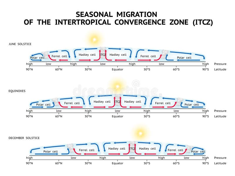

This seasonal migration has profound climatic consequences. For example, regions around 30-40° latitude (like the Mediterranean) are under the influence of the dry Subtropical High in the summer (when the belts shift north), giving them dry summers. In the winter (when the belts shift south), they fall under the influence of the stormy, wetter weather associated with the Subpolar Low, giving them wet winters.
Conclusion
Today, we have mapped out the Earth's fundamental pressure structure. We've seen that it's not a random assortment of highs and lows but a predictable pattern of distinct belts circling the globe.
Key Takeaways:
- There are four major pressure belts mirrored in each hemisphere: the Equatorial Low, Subtropical Highs, Subpolar Lows, and Polar Highs.
- The Equatorial Low and Polar Highs are thermally induced, caused by direct heating and cooling.
- The Subtropical Highs and Subpolar Lows are dynamically induced, caused by the large-scale mechanics of atmospheric circulation (sinking and rising air).
- Due to the Earth's axial tilt, this entire system of belts migrates seasonally, shifting north in the Northern Hemisphere's summer and south in its winter, following the sun's most direct rays.
Preview of the Next Lesson:
These global pressure belts create vast, semi-permanent pressure gradients. In our next lesson, we will explore the winds that flow between these belts. This will lead us to the three-cell model of global circulation (the Hadley, Ferrel, and Polar cells), which explains the planetary-scale wind systems like the Trade Winds and the Westerlies.