Hello! Welcome to our continuing exploration of geomorphology.
In our last lesson, we saw the incredible power of running water in shaping the Earth's surface, carving V-shaped valleys and building vast deltas. Today, we shift our focus from liquid water to solid ice. Glaciers, often called "rivers of ice," are among the most powerful erosional agents on the planet, capable of sculpting mountains and creating landscapes on a massive scale.
Your interest in astronomy touches on celestial ice caps, but here on Earth, glacial ice has profoundly shaped the terrain we inhabit, especially in the higher latitudes and mountain regions. This lesson will help you understand and visualize that process. Our learning outcome is to explain glacial processes and identify associated erosional and depositional landforms.
We will cover:
- How glaciers form and move.
- The erosional processes of plucking and abrasion.
- The dramatic landforms carved by glacial erosion.
- The diverse features left behind by glacial deposition.
1. The Nature of a Glacier: Formation and Movement
Before we can understand what glaciers do, we need to understand what they are. A glacier isn't just a pile of snow; it's a dynamic body of dense, moving ice.
Glacial Landforms |Erosional and Depositional Features by Glacier| Geomorphology|Dr. Krishnanand
To start, let's watch a segment from Dr. Krishnanand's lecture on geomorphology. It provides a clear, step-by-step explanation of how snowflakes transform into glacial ice and introduces the two main categories of glaciers.
Watch the video from 00:55 to 04:56. Pay attention to the sequence of glacier formation (snowflake -> granular snow -> firn -> glacial ice) and the distinction between continental and mountain/valley glaciers.
So, we have two main types: vast continental glaciers (or ice sheets) like those in Antarctica and Greenland, and alpine (or valley) glaciers, which are confined to mountain valleys.
While glaciers may seem static, they are constantly in motion, flowing under the force of gravity. This movement, although incredibly slow, gives them immense power to erode the landscape. Glaciers erode through two primary mechanisms:
- Plucking (or Quarrying): As the glacier moves, it freezes onto loosened blocks of bedrock and pulls them out.
- Abrasion: The rock fragments embedded in the base of the glacier act like sandpaper, scratching, grinding, and polishing the bedrock underneath. This process creates long, parallel scratches known as glacial striations.
An important distinction from the last lesson: while rivers tumble rocks and make them smooth and round, glaciers drag and scrape them, resulting in angular, fragmented debris.
2. Landforms of Glacial Erosion: Sculpting the Mountains
Alpine glaciers are masterful sculptors, creating some of the most dramatic mountain scenery on Earth. As they move, they transform the landscape, turning the gentle slopes and V-shaped river valleys we discussed previously into a rugged, angular terrain.
This next video segment details these spectacular erosional features.
Glacial Landforms |Erosional and Depositional Features by Glacier| Geomorphology|Dr. Krishnanand
Let's return to Dr. Krishnanand's video to explore the landforms carved by glacial ice. Notice how many of these features are related to each other.
Watch from 08:17 to 15:05. This part covers a wide range of erosional features, from the iconic U-shaped valley to smaller features like cirques and arêtes.
To reinforce these concepts, let's look at a diagram that shows how these features fit together in a mountain landscape.
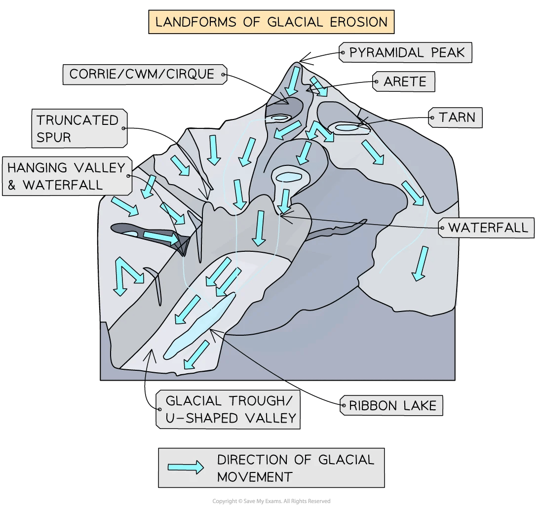
Here is a summary of the key erosional landforms:
- U-Shaped Valley (Glacial Trough): Glaciers are not confined to a narrow channel like a river. They are wide and thick, and as they flow through a pre-existing V-shaped river valley, they pluck and abrade the entire valley floor and sides, widening and deepening it into a characteristic U-shape.
- Hanging Valley: Smaller tributary glaciers often don't have the power to erode as deeply as the main glacier. After the ice melts, the floor of the tributary valley is left "hanging" high above the main valley floor, often with a waterfall cascading down.
- Cirque (or Corrie): An armchair-shaped hollow found at the head of a glacial valley, formed by plucking and abrasion as the glacier rotates and moves out.
- Tarn: A small mountain lake that forms in a cirque basin after the glacier has melted.
- Arête: A sharp, knife-like ridge formed when two glaciers erode parallel valleys or two cirques erode back-to-back.
- Horn (or Pyramidal Peak): A sharp, pointed mountain peak formed when several cirques erode a mountain from multiple sides (e.g., the Matterhorn in the Alps).
- Fjord: A long, deep, narrow inlet of the sea with steep sides, created when a U-shaped valley is flooded by a rise in sea level after the glacier has retreated. These are common in places like Norway and New Zealand.
3. Landforms of Glacial Deposition: The Debris Left Behind
When a glacier melts and retreats, it can no longer carry its enormous load of rock and sediment. It drops this material, known as glacial till, which is an unsorted mixture of everything from fine clay to giant boulders. Meltwater from the glacier can also sort and deposit this sediment, creating outwash. These deposits create a whole new set of landforms.
Glacial Erosion and Deposition
This article from Geo.LibreTexts clearly defines the different types of glacial deposits and the landforms they create. The simple diagrams and clear descriptions make it an excellent reference.
Please read the section titled 'Depositional Features of Glaciers'. Focus on understanding the difference between till and stratified drift, and learn to identify the various types of moraines and other features like drumlins and eskers.
The most common depositional landforms are moraines, which are ridges of till deposited at the edges or end of a glacier.
- Lateral Moraines: Form along the sides of a valley glacier.
- Medial Moraines: Form where the lateral moraines of two merging glaciers join in the middle.
- Terminal Moraine: A ridge of till that marks the furthest advance of a glacier.
- Ground Moraine: A thin layer of till deposited as a sheet under the melting ice.
Other important depositional landforms include:
- Glacial Erratics: Large boulders transported and deposited by a glacier, often of a rock type different from the local bedrock.
- Drumlins: Elongated, teardrop-shaped hills of till. The tapered end points in the direction of ice flow. They often occur in large groups called drumlin fields.
- Eskers: Long, winding ridges of sand and gravel, formed by meltwater streams flowing in tunnels underneath a glacier.
- Kettle Lakes: Small lakes formed when a block of ice left behind by a retreating glacier melts, leaving a depression that fills with water.
Test your understanding!
You are examining a landscape that was once covered by an ice sheet. You observe the following features:
- A long, winding ridge made of sand and gravel.
- A field of elongated, tear-drop shaped hills, all aligned in the same direction.
- A large boulder made of granite sitting in a field of limestone bedrock.
What are the likely names for these three features, and what do they tell you about the glacier that was once there?
Show answer
- The winding ridge is an esker, indicating where a meltwater stream once flowed in a tunnel beneath the ice.
- The field of hills is a drumlin field. The alignment of the drumlins tells you the direction the ice sheet was flowing.
- The boulder is a glacial erratic, showing the immense power of the ice to transport huge rocks over long distances.
Conclusion
Today, we've seen how solid ice acts as a powerful geomorphic agent, fundamentally reshaping the Earth's surface. Unlike the gradual work of rivers, glacial action is forceful and dramatic, capable of carving deep valleys, sharpening mountain peaks, and blanketing entire regions with transported debris.
Key Takeaways:
- Glaciers are moving bodies of ice that erode through plucking and abrasion.
- Erosional landforms, such as U-shaped valleys, cirques, arêtes, and horns, create dramatic, angular mountain scenery.
- Depositional landforms are made of glacial till and outwash. Key features include moraines (marking the glacier's edges and end), drumlins (showing ice direction), and eskers (marking subglacial streams).
- Glaciated landscapes are a stark contrast to the fluvial landscapes we studied, distinguished by their scale and the unique shapes of their features.
Preview of the Next Lesson:
Having explored the work of rivers and ice, we will next turn our attention to the boundary between land and sea. In the upcoming lesson on coastal processes, we will investigate how the relentless energy of ocean waves erodes cliffs, builds beaches, and constantly reshapes the world's coastlines.