Hello! Welcome to the final lesson in our module on Geomorphology.
In our previous lessons, we've journeyed through landscapes sculpted by running water and massive glaciers. We saw how rivers carve V-shaped valleys and how ice sheets create dramatic U-shaped troughs and sharp mountain peaks. Today, we arrive at the dynamic boundary where the land meets the sea. The world's coastlines are zones of constant change, shaped by the relentless energy of ocean waves.
This lesson directly addresses your interest in physical geography by exploring one of its most active and fascinating frontiers. Our learning outcome is to explain coastal processes and identify associated erosional and depositional landforms.
We will cover:
- The fundamental processes of coastal erosion, transportation, and deposition.
- How wave action sculpts rocky coastlines into dramatic features like cliffs, arches, and stacks.
- How sediment is deposited to build landforms such as beaches, spits, and bars.
This lesson concludes our study of the physical forces that shape Earth's surface. From here, we will transition to the methods we use to represent and analyze these landscapes, beginning your requested deep dive into mapping and GIS.
1. The Engine of Change: Waves and Coastal Processes
The primary agent shaping our coastlines is the ceaseless motion of waves. The way waves interact with the shore dictates whether the coast is worn away (eroded) or built up (deposited).
Coastal Landforms |Erosional and Depositional Features by Waves| Geomorphology|Dr. Krishnanand
To begin, let's watch a short introduction from Dr. Krishnanand. This segment clearly explains the basic mechanics of wave action, including the important concepts of 'swash' and 'backwash,' which determine whether a wave is building up the coast or tearing it down.
Watch from the beginning (00:11) to 04:24. Focus on understanding the difference between swash (water moving up the beach) and backwash (water moving back down), and how their relative strength defines 'constructive' and 'destructive' waves.
As the video explained, waves are the engine of change, but how exactly do they erode solid rock? The process isn't just about impact; it involves several distinct mechanisms.
Coastal processes and landforms - BBC Bitesize
The BBC Bitesize page on coastal processes provides excellent, clear definitions for the primary ways waves erode the coastline. It also introduces the crucial process of longshore drift, which is key to understanding how sediment moves along the coast.
Read the first part of the article under the heading 'Coastal processes', covering Erosion, Transportation, and Deposition. Pay close attention to the definitions of the four types of erosion and the diagram showing longshore drift.
To summarize the key processes from that reading:
- Erosion: The wearing away of the land.
- Hydraulic Action: Air is trapped and compressed in cracks in the rock by the force of the waves, causing the rock to shatter.
- Abrasion: Rocks and sediment carried by the waves are hurled against the cliff face, acting like sandpaper.
- Attrition: Rock fragments carried by the sea collide with each other, breaking down into smaller, smoother, and more rounded pieces.
- Solution (Corrosion): Certain types of rock, like limestone and chalk, are slowly dissolved by the slightly acidic seawater.
- Transportation: The movement of eroded material. The most important process is Longshore Drift, where sediment is moved along the coast in a zigzag pattern due to waves approaching the shore at an angle.
- Deposition: The dropping of sediment. This occurs when waves lose energy and can no longer carry their load, typically in sheltered areas like bays.
2. Sculpting the Land: Erosional Landforms
The type of landforms found on a coast depends heavily on its geology. On high, rocky coastlines composed of resistant rock, erosion is the dominant process, carving out a range of spectacular features. Low-lying coasts made of softer sediment are more prone to deposition, which we'll cover next.
The Britannica article on "Landforms of erosional coasts" (Resource LINK) provides a good overview of this type of rugged coastline, which is often found on the leading edge of tectonic plates.
Let's explore the classic sequence of landforms created as a headland (a point of land jutting out into the sea) is eroded.
Coastal processes and landforms - BBC Bitesize
The BBC Bitesize article has a fantastic step-by-step visual guide showing how a solid headland is progressively worn down into a series of distinct landforms. This visual sequence is one of the best ways to understand the process.
Scroll down to the 'Formations' section and carefully review the five-step diagram sequence under 'How a stump is formed'. Follow the process from crack to cave, arch, stack, and finally, stump.
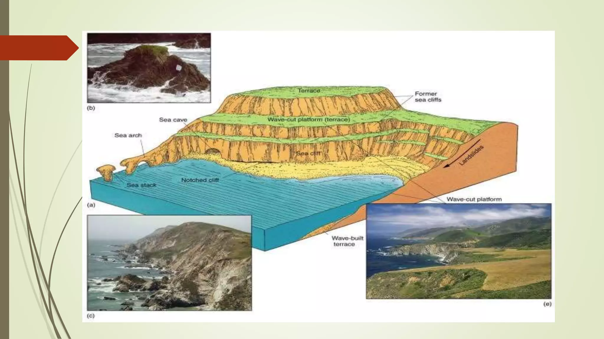
This erosional sequence creates the following features:
- Sea Caves: Hydraulic action and abrasion widen weaknesses and cracks at the base of a cliff to form a cave.
- Sea Arch: When caves on opposite sides of a headland erode and meet, or a single cave erodes right through, it forms a natural arch.
- Sea Stack: The roof of the sea arch eventually becomes unstable and collapses due to gravity and further erosion, leaving a tall, isolated pillar of rock known as a stack.
- Stump: The stack is further eroded at its base by the waves. Eventually, it collapses to form a small, often submerged, rocky outcrop called a stump.
Two other major erosional features are often found together:
- Sea Cliff: A steep rock face that borders the coast. Waves attack its base, creating a "wave-cut notch." This undercuts the cliff, causing the rock above to collapse, leading to the cliff's retreat.
- Wave-Cut Platform: As the cliff retreats, it leaves behind a wide, flat, rocky platform at its base, which is often visible at low tide. This platform represents the base of the former cliff.
Test your understanding!
You are observing a rocky coastline. You see a tall, isolated pillar of rock standing just offshore from a headland. What is this feature called, and what two landforms likely existed before it was formed?
Show answer
The feature is a sea stack. Before it formed, there was likely a sea arch, and before that, one or more sea caves that eroded through the headland.
3. Building New Land: Depositional Landforms
While waves have immense power to destroy, they also have the ability to build. On coastlines where wave energy is lower, or where there is an abundant supply of sediment, deposition becomes the dominant process. This is particularly common on low, gently sloping coasts.
The movement of sediment by longshore drift is the primary architect of these features.
Coastal Landforms |Erosional and Depositional Features by Waves| Geomorphology|Dr. Krishnanand
Let's return to Dr. Krishnanand's video. This final segment showcases the most common landforms created by deposition.
Watch from 08:42 to 11:15. Pay attention to the different types of bars and how they are distinguished from spits and tombolos. Note how a lagoon is formed.

Here is a summary of the primary depositional landforms:
- Beaches: The most common depositional landform, consisting of accumulated sand or pebbles in the area between the high and low tide marks.
- Spit: A long, narrow ridge of sand or shingle that is attached to the land at one end and extends out into the sea or across an estuary. It is formed by longshore drift carrying sediment along the coast. The end of a spit is often curved by the action of wind and waves, forming a hook.
- Bar (or Baymouth Bar): When a spit grows completely across a bay, it traps a body of water behind it. This feature is called a bar.
- Lagoon: The body of calm water trapped behind a bar.
- Tombolo: A spit or bar that connects an island to the mainland or to another island.
Conclusion
Today we have explored the dynamic and ever-changing world of coastlines. We've learned that the coast is a battleground between the erosive power of waves and the constructive process of deposition, with the victor determined by geology and wave energy.
Key Takeaways:
- Coastal landforms are primarily shaped by wave action through the processes of erosion, transportation, and deposition.
- Longshore drift is the key transportation process, moving sediment along the coastline.
- Erosional coasts are characterized by features like cliffs, wave-cut platforms, and the sequential formation of caves, arches, stacks, and stumps.
- Depositional coasts are built up by sediment, forming beaches, spits, bars, and tombolos.
Preview of the Next Lesson:
This lesson concludes our geomorphology module, where we have studied how water, ice, and waves sculpt the physical surface of our planet. Now that you have a strong foundation in understanding these landforms, our next module, "Introduction to Thematic Mapping and GIS," will equip you with the tools to visualize, map, and analyze them. We will start by exploring the principles of creating effective thematic maps, a crucial first step in your journey into cartography and spatial analysis.