Hello! Welcome to our final lesson in the module on Geomorphology.
Over the past few lessons, we've explored landscapes sculpted by the immense power of rivers, glaciers, and coastal waves. Today, we turn our attention to the driest places on Earth, where another powerful force shapes the surface: the wind.
This lesson addresses the final learning outcome for this module: to explain aeolian (wind) processes and identify associated landforms in arid environments. Aeolian processes are fundamental to physical geography and create some of the most striking and dynamic landscapes on our planet—and beyond, which will connect with your interest in astronomy.
We will cover:
- The primary ways wind erodes, transports, and deposits sediment.
- The key erosional landforms carved by wind, such as yardangs and ventifacts.
- The major depositional landforms built by wind, especially the different types of sand dunes.
This lesson concludes our survey of the major external forces that shape the Earth's surface. With this foundation, you'll be well-prepared for our next module, where we will begin to explore the tools used to map and analyze these incredible landscapes.
1. The Power of Wind: Aeolian Processes
The term "aeolian" comes from Aeolus, the Greek god of winds. Aeolian processes refer to the wind's ability to erode, transport, and deposit materials. These processes are most effective in arid and semi-arid regions where there is little vegetation to hold loose sediment in place.
Like water, wind moves sediment in three main ways, depending on the particle size and wind velocity.
Weathering Environments Part 2: Aeolian Processes
To understand how wind shapes landscapes, we first need to see how it moves sediment. This video from the channel Professor Dave Explains provides a clear, concise explanation of the three ways wind transports particles.
Watch from the beginning (00:06) to 01:16. Focus on the concepts of traction (or creep), saltation, and suspension, and how the size of the particle determines its mode of transport.
As the video showed, the key transportation mechanisms are:
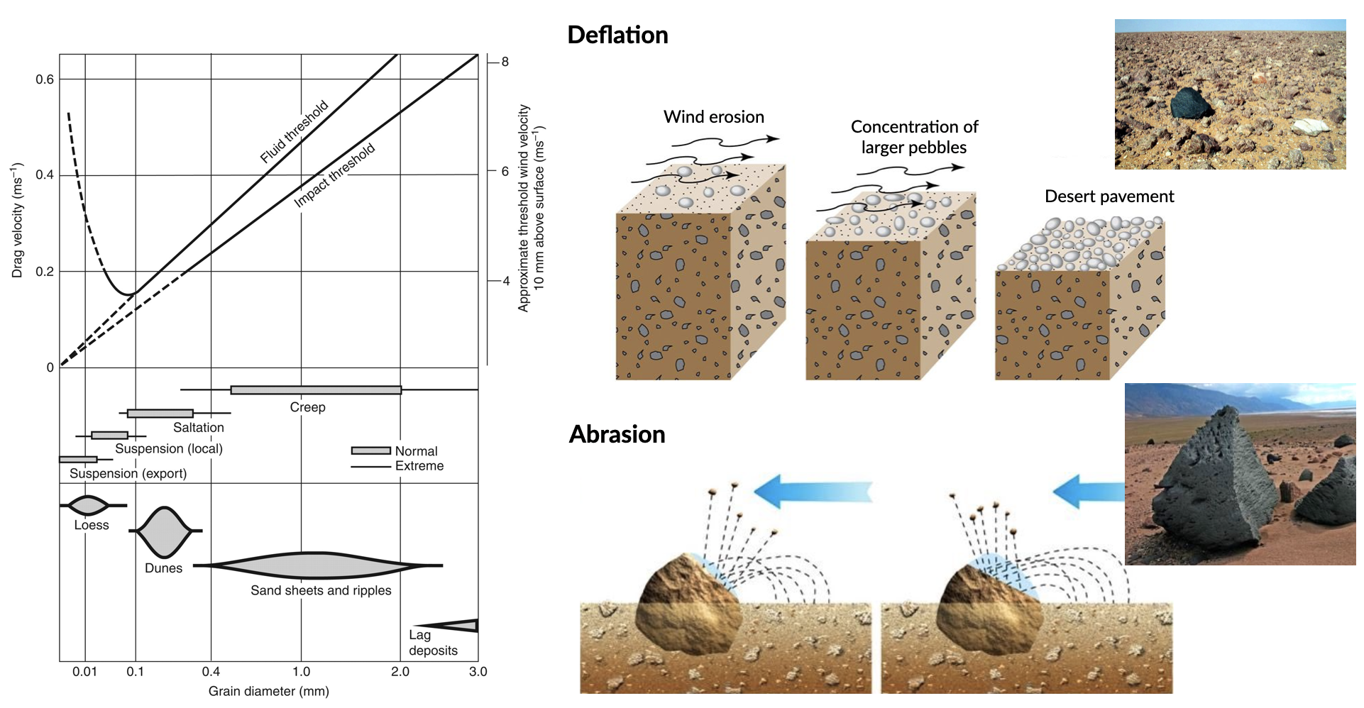
- Suspension: The finest particles, like dust and silt, are lifted and carried long distances by the wind.
- Saltation: Sand-sized particles move in a series of bounces or leaps. This process accounts for the vast majority of sand transport.
- Traction (or Surface Creep): Larger grains are too heavy to be lifted but are pushed or rolled along the ground by the impact of saltating grains.
This moving sediment becomes a powerful tool for erosion through two primary processes:
- Deflation: The process of lifting and removing loose particles from the surface. Imagine the wind blowing away all the sand and dust from a patch of desert, leaving only heavier pebbles behind.
- Abrasion: The "sandblasting" effect where wind-driven particles strike rock surfaces, grinding them down, polishing them, and carving them into new shapes.
This powerful image below provides a fantastic summary, linking wind velocity, particle size, transportation methods, and the resulting erosion and deposition processes.
2. Sculpting the Land: Erosional Landforms
Over thousands of years, deflation and abrasion carve distinctive landforms into the desert rock.
Aeolian Landforms|Erosional and Depositional Features by Wind| Geomorphology|Dr. Krishnanand
Now that we understand the processes, let's look at the landforms they create. Dr. Krishnanand's video provides a detailed tour of various erosional features. We'll watch this in two parts.
First, watch from 04:51 to 09:08. This section covers features formed by deflation and large-scale erosion, such as desert pavement, pediments, and deflation hollows. Then, continue watching from 09:08 to 13:57 to see landforms sculpted by abrasion, including mushroom rocks, yardangs, and ventifacts.
Based on the video, here is a summary of the main erosional landforms:
- Desert Pavement (or Reg, Hamada): A surface layer of closely packed, interlocking stones left behind after wind has removed the finer sand and silt through deflation. This stony layer can protect the underlying material from further erosion.
- Deflation Hollows (or Blowouts): Basins or depressions created where wind has scoured away loose sediment.
- Ventifacts: Rocks that have been abraded, pitted, grooved, or polished by wind-driven sand. They often have sharp edges and flat faces pointing towards the prevailing wind. A rock with three such faces is called a dreikanter.
- Yardangs: Elongated, streamlined ridges of rock, aligned parallel to the prevailing wind. They are formed by wind abrasion in areas with unidirectional winds, looking like the inverted hull of a ship.
- Mushroom Rocks (or Pedestal Rocks, Zeugen): Isolated rock outcrops that have been eroded more at their base than at their top. Abrasion is most effective within a meter of the ground where saltating sand is concentrated, leading to this distinctive mushroom shape.

Test your understanding!
Imagine you are in a desert and see a large, isolated rock shaped like a mushroom. What is this feature called, and what specific aeolian process is most responsible for its unique shape?
Show answer
This feature is called a mushroom rock (or pedestal rock/zeugen). Its shape is primarily caused by abrasion, which is most intense near the ground where the concentration of saltating sand particles is highest, thus eroding the base of the rock faster than the top.
3. Building New Land: Depositional Landforms
When wind velocity decreases or it encounters an obstacle, it drops the sediment it is carrying. This deposition creates some of the most iconic desert landscapes.
Sand Dunes
The most famous depositional landforms are sand dunes. A dune is not a static feature; it actively moves. Sand saltates up the gentle windward slope (the stoss side) and accumulates at the crest. When the crest becomes too steep, the sand avalanches down the steeper leeward slope, known as the slipface. This process causes the entire dune to migrate slowly downwind.
Eolian Processes - USGS Publications Warehouse
To understand the mechanics of how dunes form and move, let's read a short selection from the U.S. Geological Survey (USGS).
Read the section titled 'Eolian deposition'. Focus on the descriptions of sand sheets and ripples, and pay close attention to the diagram and explanation of how dunes move via saltation up the windward side and avalanching down the slipface.
Dunes come in various shapes and sizes, determined primarily by the amount of available sand and the characteristics of the wind.
Weathering Environments Part 2: Aeolian Processes
Dune shapes are a direct reflection of their environment. This segment from Professor Dave Explains provides a quick and clear overview of the main dune types and the wind conditions that create them.
Watch from 01:43 to 03:30. Note the four main types presented: transverse, parabolic, longitudinal, and star dunes, and the wind patterns associated with each.
Here is a summary of the most common dune types:
| Dune Type | Wind Direction(s) | Sand Supply | Key Feature |
|---|---|---|---|
| Barchan | Unidirectional | Limited | Crescent-shaped, with horns pointing downwind. They often move across a flat, rocky surface. |
| Parabolic | Unidirectional | Abundant | U-shaped or V-shaped, with horns pointing upwind. Often anchored by vegetation. |
| Transverse | Unidirectional | Abundant | Long, wavy ridges oriented perpendicular to the prevailing wind, like sandy ripples on a giant scale. |
| Longitudinal | Bidirectional | Abundant | Long, straight ridges of sand aligned parallel to the average wind direction. |
| Star | Multidirectional | Abundant | A complex, pyramidal dune with several radiating arms and multiple slipfaces, formed where winds blow from various directions. |
Other Depositional Features
Wind deposition creates more than just dunes.
Aeolian Landforms|Erosional and Depositional Features by Wind| Geomorphology|Dr. Krishnanand
To complete our look at deposition, let's finish Dr. Krishnanand's video. This final part covers other significant features created by wind deposition.
Watch from 13:57 to the end (16:43). Focus on the definitions of ergs (sand seas), playas (desert lakes), and loess deposits.
- Ergs (or Sand Seas): Vast, flat areas of desert covered with wind-swept sand, often with numerous dunes.
- Playas: Also known as salt flats or pans. These are dry lakebeds found in desert basins. Water may collect here after rain, but it quickly evaporates, leaving behind layers of salt and fine mud.
- Loess: Extensive blankets of fine-grained, wind-blown silt. Loess is very fertile and forms the basis for some of the world's most productive agricultural soils, such as those on the Loess Plateau in China.
4. Aeolian Landscapes Beyond Earth
The physical laws governing wind erosion and deposition are universal. As you have an interest in astronomy, it’s fascinating to see these same processes at work on other planets and moons in our solar system.
Weathering Environments Part 2: Aeolian Processes
Let's take a quick journey off-planet. This final clip from Professor Dave offers a fascinating glimpse of aeolian features on Mars and Saturn's moon, Titan.
Watch from 03:30 to the end (05:00). Notice how the principles of dune formation apply even when the atmosphere is thin (like on Mars) or the sand is made of different materials (like frozen hydrocarbon particles on Titan).
This extraterrestrial connection is a perfect example of how understanding fundamental principles in physical geography allows us to interpret landscapes across the cosmos. The barchan dunes on Mars are shaped by the same physics as those in the Sahara, even though the sand is made of different material (basalt) and the atmosphere is much thinner.
Conclusion
This lesson brings our geomorphology module to a close. We have seen how wind, a seemingly gentle force, can carve rock and build massive landscapes in the world's arid regions.
Key Takeaways:
- Aeolian processes are driven by wind and include erosion (deflation, abrasion), transportation (suspension, saltation, creep), and deposition.
- Major erosional landforms include desert pavement, deflation hollows, ventifacts, yardangs, and mushroom rocks.
- The primary depositional landforms are sand dunes, which come in various types (Barchan, Parabolic, Transverse, Longitudinal, Star) depending on wind and sand supply. Other features include loess and playas.
- These physical processes are universal and can be observed shaping landscapes on other worlds, like Mars and Titan.
Preview of the Next Lesson:
You have now built a strong foundation in geomorphology, understanding the forces that sculpt our planet's fluvial, glacial, coastal, and arid landscapes. Now, how do we represent and analyze these complex surfaces?
Our next module, Introduction to Thematic Mapping and GIS, will begin to answer that question. We'll start your requested deep dive into mapping by exploring the fundamental principles of cartographic design for creating effective thematic maps. This is the first step toward learning how to tell powerful geographic stories with data, whether you're mapping the world's deserts, climate zones, or population patterns.