Hello! Welcome to our final lesson in the "Geomorphology: Sculpting the Earth's Surface" module.
In our last lesson, we explored the powerful force of wind in shaping arid landscapes. We've now examined how rivers, glaciers, coasts, and wind—all external, physical forces—sculpt the Earth. Today, we turn to a different kind of process: chemical weathering, where the landscape is dissolved from within.
This lesson will address the final learning outcome for this module: to describe the formation of karst topography through chemical weathering in limestone regions. Karst landscapes are some of the most unique and mysterious on Earth, characterized by caves, sinkholes, and disappearing rivers.
We will cover:
- The essential ingredients for karst: soluble rock (like limestone) and acidic water.
- The chemical reaction at the heart of the process: carbonation.
- The major surface and subsurface landforms that define a karst region.
- How these features are all part of a single, interconnected hydrological system.
Completing this topic will round out your understanding of the major geomorphic processes. With this knowledge, you'll be well-equipped for our next module, where we will start your requested deep dive into the world of mapping and GIS.
1. The Chemistry of Disappearing Rock
Karst topography is a landscape formed from the dissolution of soluble rocks. While several rock types are soluble, the most common and extensive karst landscapes develop on limestone.
To understand how a solid rock like limestone can be carved into vast cave systems, we need to look at two things: what limestone is made of, and how it reacts with rainwater.
This video from Atlas Pro provides an excellent and engaging introduction to the process. It starts with the spectacular Son Doong cave in Vietnam before breaking down the science.
Watch from 02:37 to 05:04. Pay close attention to two key ideas: How limestone is formed from the calcium carbonate shells of marine organisms. How rainwater becomes slightly acidic (forming carbonic acid) and dissolves this limestone.
As the video explained, the process hinges on a simple chemical reaction. Here's a step-by-step breakdown:
- Limestone Formation: Limestone is a sedimentary rock composed primarily of calcium carbonate (). This material is sourced from the shells and skeletons of countless marine organisms that have been compressed over millions of years.
- Acid Formation: As rain falls through the atmosphere, it absorbs carbon dioxide (). It picks up even more as it percolates through soil, which is rich in decaying organic matter and respiring microbes. This creates a weak acid called carbonic acid ().
- Dissolution (Carbonation): This weak carbonic acid is very effective at dissolving calcium carbonate. The acid reacts with the limestone, converting it into calcium bicarbonate (), which is soluble in water and can be carried away.
This process of chemical weathering is known as carbonation. Over thousands to millions of years, this slow, persistent dissolution carves out a distinctive and complex landscape both on the surface and deep underground.
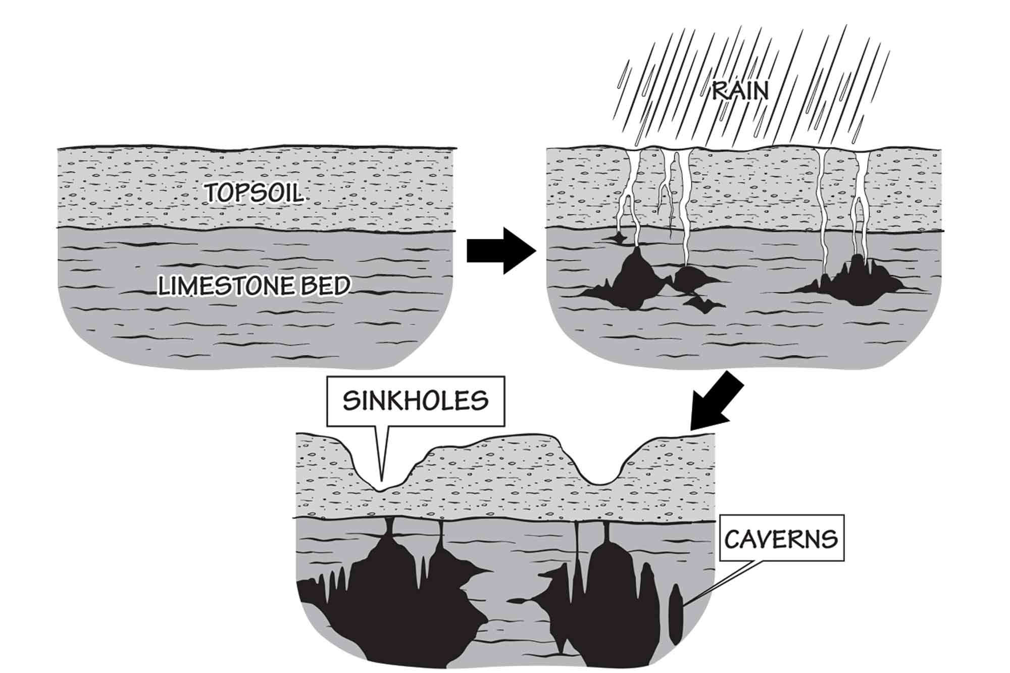
2. The Architecture of a Karst Landscape
A karst landscape is more than just a collection of random features; it's a highly integrated three-dimensional system. We can think of it as having three main zones, as described in the "Karst Geomorphology" text.
Karst Geomorphology, Hydrology, and Management
To understand the structure of a karst landscape, let's read a short section from a technical handbook on the topic. It introduces a useful three-part model.
Please read the section that begins with 'In the broadest sense, the three-dimensional nature of a karst landscape...'. It's on page 381 of the document (page 10 of the PDF). Focus on the definitions of exokarst, epikarst, and endokarst.
- Exokarst: All the features found on the surface.
- Epikarst: The highly weathered zone just below the surface, which acts as a crucial interface, transferring water from the surface into the deeper system.
- Endokarst: The deep underground components, including caves and conduits.
This framework helps us organize the specific landforms that result from carbonation.
3. Surface Features (Exokarst)
The surface of a karst landscape is often defined by what is missing—namely, surface streams and rivers. Water quickly disappears underground through a network of fissures and drains. This creates a unique set of landforms.
This video from Mr Gedge's Geography Channel provides a comprehensive tour of the most common karst features, both on the surface and underground. We'll watch it in two parts. First, let's focus on the surface.
Watch from 04:47 to 06:03 and then from 06:25 to 07:25. This will cover sinkholes, dry valleys, poljes, and limestone pavements.
Here are the key surface features you'll encounter:
- Sinkholes (or Dolines): These are depressions in the ground that are hallmarks of a karst landscape. They can form in two main ways:
- Solution Sinkholes: Formed gradually as surface water dissolves the bedrock from the top down.
- Collapse Sinkholes: Formed suddenly when the roof of an underground cave collapses.
- Sinking Streams (or Swallets): A stream or river that disappears underground, often into a sinkhole or a crack in the bedrock. The point of disappearance is the swallet.
- Resurgence: The point where an underground stream re-emerges at the surface. This is effectively a spring fed by the karst drainage system.
- Dry Valleys: A valley that appears to have been carved by a river but no longer has a permanent stream. The water that once flowed on the surface now flows underground.
- Polje: A very large, flat-floored basin with steep sides. They are often formed by the merging of several sinkholes and can be miles long.
- Limestone Pavement: A large area of exposed limestone where the surface has been broken into blocks (called clints) by a network of enlarged joints (called grykes). This creates a striking, geometric pattern.

4. Subsurface Features (Endokarst)
The dissolution of limestone doesn't stop at the surface. As water works its way down through joints and fractures, it enlarges them into a network of passages, creating the underground world of caves.
Inside these caves, another fascinating process occurs. The water that dissolved the calcium bicarbonate may drip from the ceiling or flow along the walls. As this water is exposed to the air inside the cave, it releases some of its carbon dioxide, causing the chemical reaction to reverse. The calcium carbonate is re-deposited, creating beautiful and intricate cave formations called speleothems.
Let's return to the video from Mr Gedge's Geography Channel to see the incredible features that form inside caves.
Watch from 03:04 to 04:21. Focus on the different types of speleothems and how they form: stalactites, stalagmites, and pillars.
The most common speleothems are:
- Stalactites: These grow down from the ceiling of the cave (remember 'c' for ceiling or 't' for tight to the ceiling).
- Stalagmites: These grow up from the floor of the cave (remember 'g' for ground).
- Pillars (or Columns): Formed when a stalactite and a stalagmite meet and fuse together.
- Flowstones: Sheet-like deposits of calcite formed where water flows down walls or along floors.
Test your understanding!
A hiker in a limestone region notices a river disappearing into a large hole in the ground. A few kilometers away, in a deep valley, they see a powerful spring gushing water out of the base of a cliff. How might these two features be related, and what are their proper geographic names?
Show answer
These two features are very likely connected by an underground river flowing through a cave system. The hole where the river disappears is called a swallet or sinking stream. The spring where the water reappears is called a resurgence. This is a classic example of the interconnected hydrology in a karst landscape.
Conclusion
This lesson concludes our journey through geomorphology. We've seen how chemical weathering, specifically the dissolution of limestone by carbonic acid, creates the unique and complex landscapes of karst regions.
Key Takeaways:
- Karst topography forms when soluble rock, mainly limestone (), is dissolved by weakly acidic water (carbonic acid, ). This process is called carbonation.
- The landscape is a three-dimensional system of exokarst (surface), epikarst (near-surface), and endokarst (subsurface).
- Key surface features include sinkholes, sinking streams, dry valleys, and limestone pavements.
- Key subsurface features include caves and the depositional formations within them, known as speleothems (stalactites, stalagmites, etc.).
Preview of the Next Lesson:
You have now built a strong foundational understanding of the major processes that shape Earth's physical surface. The next logical step, and one you've specifically requested to focus on, is learning how geographers represent, analyze, and communicate information about these landscapes.
We will now move into the module Introduction to Thematic Mapping and GIS. Our very first lesson will address the learning outcome: Explain principles of cartographic design for creating effective thematic maps. This is where we shift from understanding the world to learning the art and science of depicting it.