Hello! Welcome to our next lesson in geomorphology.
In our last lesson, we explored how gravity pulls weathered rock and soil down slopes in a process called mass wasting. This process delivers a vast amount of sediment to the base of slopes and into stream channels. But what happens to that material next? This is where the power of running water takes over.
Today, we will focus on fluvial processes, which are all the ways that rivers and streams shape the Earth's surface. Our goal is to explain these fluvial processes and identify the associated erosional and depositional landforms they create. From carving colossal canyons to building vast, fertile plains, rivers are arguably the most important agents of erosion on the planet.
1. The River System: A Journey from Source to Sea
Before diving into specific processes, it's helpful to see a river not as a single line on a map, but as a complete system with three distinct zones. Each zone is characterized by a dominant process.
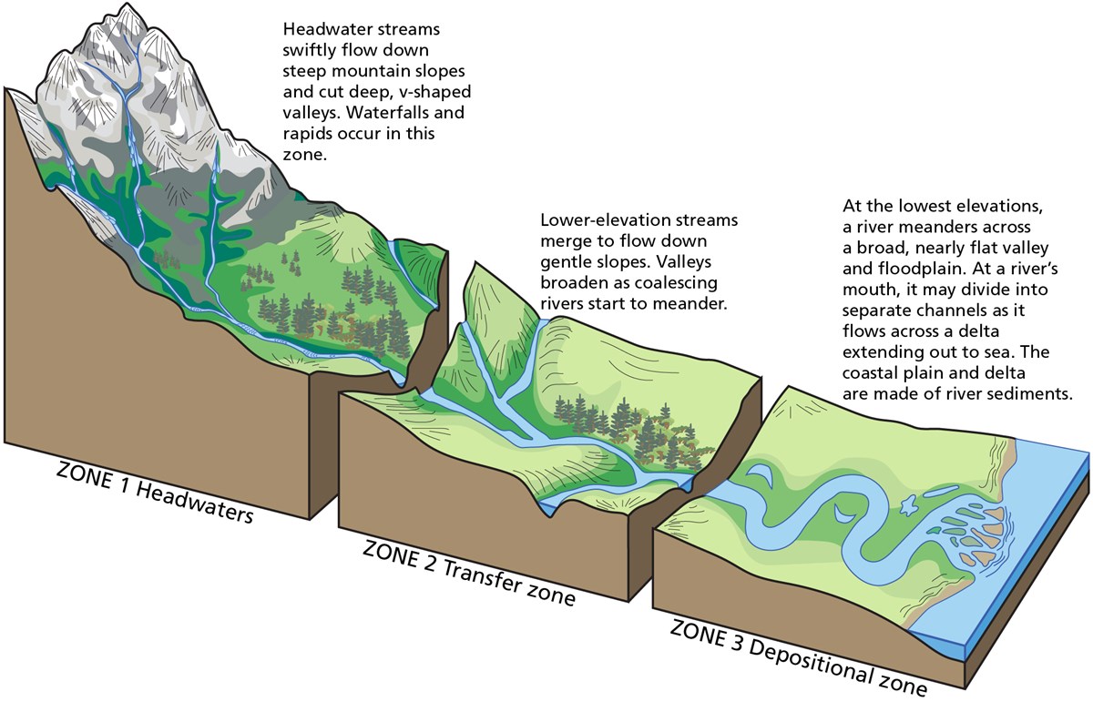
We'll use this three-part framework to structure our exploration of how rivers work.
2. Fundamental Fluvial Processes
Rivers perform three main types of work: erosion, transportation, and deposition. The balance between these depends on the river's energy, which is primarily determined by its velocity and volume of water.
The following video provides an excellent introduction to these concepts, using the Zambezi River as a running example.
How Rivers Shape the Landscape: Crash Course Geography #23
This Crash Course Geography video gives a great overview of how a river's energy and location influence its ability to shape the landscape. It will introduce us to the concepts of drainage basins and the different parts of a river's course.
Please watch the following two segments: From 01:00 to 02:45 to understand what a river is and where its water comes from. From 04:48 to 05:38 to learn about stream gradient and how it dictates a river's energy and ability to erode and transport sediment.
As the video explained, a river's power comes from its energy. This energy allows it to perform its work:
- Erosion: The process of picking up rock and soil particles from the river bed and banks. This happens in several ways, including the sheer force of the water (hydraulic action), the grinding action of sediment already in the flow (abrasion), and the chemical dissolving of certain rocks (corrosion/solution).
- Transportation: The movement of the eroded material, which is called the river's load.
- Deposition: The process of dropping the sediment load. This occurs when the river loses energy, typically because its velocity decreases.
How Rivers Carry Their Load
A river's load is transported in three main ways. The analogy of making a protein shake or mixing powder into water is surprisingly accurate here!
Fluvial (Rivers) Geomorphology | Physical Geography with Professor Patrich
This video from Prof. Jeremy Patrich clearly explains the three types of sediment load in a river using a very memorable analogy.
Watch from 17:12 to 19:54. Focus on the definitions and visual examples of bed load, suspended load, and dissolved load.
To summarize:
- Bed Load: Heavy particles (sand, gravel, boulders) that are rolled, bounced, or dragged along the riverbed.
- Suspended Load: Fine particles (silt, clay) that are light enough to be held up and carried along within the water flow, making it look muddy.
- Dissolved Load: Soluble minerals that have been dissolved in the water and are carried in solution.
3. Landforms of River Erosion (Zone 1)
In the upper course or headwaters, where gradients are steep and river velocity is high, erosion is the dominant process. This carves out distinctive landforms.
To begin, please read this short text that introduces how erosional landforms are created.
This excerpt from the NCERT textbook, Landforms and their evolution, systematically describes the primary landforms created by river erosion.
Please read the section titled 'EROSIONAL LANDFORMS', starting from 'Valleys' and ending before 'DEPOSITIONAL LANDFORMS'. This section describes V-shaped valleys, gorges, canyons, potholes, plunge pools, and river terraces.
Let's highlight the most prominent erosional features:
- V-Shaped Valleys: In their youthful stage, rivers have so much vertical cutting power that they carve deep, narrow valleys. Mass wasting on the valley sides then creates the characteristic "V" shape.
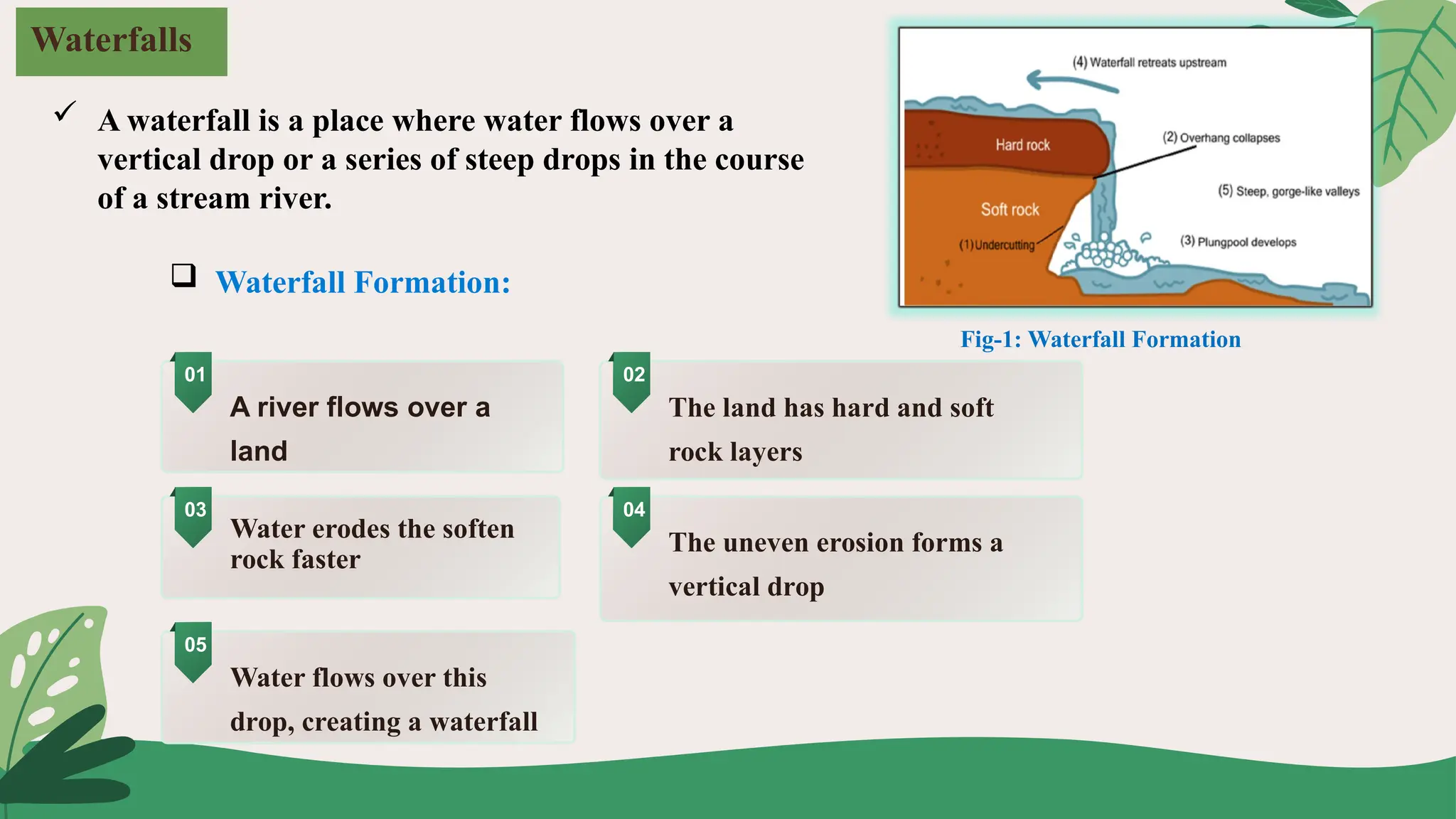
- Waterfalls and Plunge Pools: These form where a river flows over a layer of hard, resistant rock onto a softer, more easily eroded rock layer. The erosion of the soft rock undercuts the hard rock, creating a vertical drop. The force of the falling water carves a deep plunge pool at the base.
- Gorges and Canyons: These are essentially very deep, steep-sided V-shaped valleys. Gorges are typically formed in hard, resistant rock, while canyons often form in horizontally layered sedimentary rock, giving them a step-like appearance.
4. Landforms of Deposition (and Erosion) in the Middle and Lower Courses
As a river moves into its middle and lower course (Zones 2 and 3), its gradient decreases, it carries a heavier load, and its work changes. Here we see a mix of erosion and deposition creating some of the most iconic river features.
Meanders, Cut Banks, and Point Bars
Rivers rarely flow in straight lines on gentle slopes. They develop curves called meanders. The formation of meanders is a perfect example of how erosion and deposition work together.
Fluvial (Rivers) Geomorphology | Physical Geography with Professor Patrich
This segment clearly illustrates the physics behind why rivers curve and how meanders evolve, leading to other features like oxbow lakes.
Watch from 12:18 to 16:23. Pay close attention to the animation showing where the water flows fastest in a curve. This explains why erosion happens on the outside bend and deposition on the inside bend.
As you just saw, in a meander bend:
- The fastest-flowing water is thrown to the outside of the curve. This high-energy water erodes the bank, forming a steep cut bank.
- The slowest-flowing water is on the inside of the curve. This low-energy water drops its sediment, building a gently sloping deposit called a point bar.
This process causes meanders to migrate, or move, across the landscape over time. Eventually, a meander loop can become so exaggerated that the river cuts a new, shorter channel, abandoning the old loop and forming an oxbow lake.
Test your understanding!
Imagine you are canoeing down a meandering river and want to set up a tent for the night. You see a steep, cliff-like bank on the outside of a bend and a sandy, gently sloping beach on the inside of the bend. Which location would be a safer place to camp and why?
Show answer
The sandy, gently sloping beach on the inside of the bend (the point bar) would be the safer place. This is an area of active deposition, meaning the river is adding land here. The steep, cliff-like bank on the outside (the cut bank) is an area of active erosion, meaning the river is eating away at the land, making it unstable and prone to collapse.
Floodplains, Levees, Deltas, and Alluvial Fans
When a river overtops its banks during a flood, it loses energy and deposits a layer of sediment over the surrounding flat land, creating a floodplain. The coarsest sediment is dropped first, right along the river banks, building up natural raised embankments called natural levees.
Finally, when a river reaches a large body of standing water like a lake or the ocean, it loses almost all its energy and deposits its entire remaining load. This forms a triangular, fan-shaped landform called a delta. A similar feature, called an alluvial fan, forms on land where a steep mountain stream emerges onto a flat plain.
This table from a lab manual is a fantastic summary for identifying these key landforms.
Lab 21: Fluvial Geomorphology and Landforms
This table provides concise definitions and identifying characteristics for the major fluvial landforms. It's an excellent tool for review and for applying your knowledge to maps.
Review Table 21.1. You don't need to memorize it, but notice how it clearly defines and differentiates between landforms like point bars, cut banks, oxbow lakes, deltas, and alluvial fans.
5. From Youth to Old Age: The Evolution of a River Landscape
Just as we saw with the cycle of erosion in our last lesson, we can classify parts of a river or an entire river system by its stage of development. This model helps synthesize everything we've discussed.
Fluvial (Rivers) Geomorphology | Physical Geography with Professor Patrich
Let's revisit the concept of landscape evolution, this time focusing specifically on river systems. This video provides a great summary of the characteristics of 'Young', 'Mature', and 'Old' river stages.
Watch from 06:19 to 10:00. This segment details the progression from a young, steep, V-shaped system to a mature, meandering system, and finally to an old-age system with a wide floodplain and oxbow lakes.
- Youth: Steep gradient, V-shaped valley, waterfalls, rapids. Erosion dominates.
- Maturity: Gentler gradient, wider valley, developed floodplain, distinct meanders, point bars, cut banks.
- Old Age: Very low gradient, extremely wide floodplain, extensive meanders, oxbow lakes, natural levees.
Conclusion
Today we've journeyed downriver from the steep headwaters to the flat coastal plains. We've seen how a river's energy dictates whether it erodes, transports, or deposits sediment, and how these processes create a diverse and dynamic array of landforms that define much of the world's scenery.
Key Takeaways:
- Rivers shape landscapes through three primary processes: erosion, transportation, and deposition.
- A river's energy, controlled by its gradient and velocity, determines which process is dominant.
- Erosional landforms like V-shaped valleys and waterfalls are characteristic of a river's steep, youthful upper course.
- Depositional landforms like deltas and wide floodplains characterize a river's gentle, old-age lower course.
- Features like meanders, cut banks, and point bars are created by a combination of erosion and deposition in the middle course.
Preview of the Next Lesson:
We've now seen the incredible power of water in its liquid form. In our next lesson, we will investigate what happens when water turns to ice. We'll explore glacial processes, discovering how massive sheets of moving ice can sculpt mountains, carve out enormous lakes, and transport boulders the size of houses, leaving behind a completely transformed landscape.