Hello! Let's begin our next lesson in our journey through atmospheric moisture.
In our previous session, we unraveled the mystery of what type of precipitation reaches the ground. We saw that the temperature profile of the atmosphere is the critical factor that determines whether a snowflake from a cloud arrives as snow, rain, sleet, or freezing rain. We now have a good understanding of the processes inside and below the cloud.
Today, we'll zoom out and ask a more fundamental question: What causes the air to rise and form these precipitation-producing clouds in the first place? The answer lies in large-scale atmospheric dynamics. Our goal for this lesson is to analyze the mechanisms of conventional, orographic, and frontal precipitation. These are the three primary "engines" that lift vast amounts of air, setting the entire process of cloud formation and precipitation in motion.
The Unifying Principle: Lifting Air to Make Rain
Before we examine each mechanism, it's crucial to understand the single principle that unites them all. For clouds and rain to form, a parcel of moist air must be lifted and cooled to its dew point temperature.
The website of the US National Weather Service provides an excellent framework for this, which they call "The Precipitation Ladder." The key insight is that lifting, or ascent, is the foundational step.
Let's read a short but very important explanation from the US National Weather Service on how lifting air is the key to cloud formation. This will provide the core scientific principle for our entire lesson.
Please read the section titled 'THE PRECIPITATION LADDER'. Start from the paragraph beginning with 'Ascent and Expansion are two of the main processes...' and continue to the end of the section just before 'Now that we have begun cooling the air parcel...'. Focus on the four named processes that cause air to rise, and the description of what happens to an air parcel as it ascends.
As you've just read, the process is:
- Ascent: Air is forced to rise.
- Expansion: As it rises, it moves into a region of lower atmospheric pressure, causing it to expand.
- Cooling: This expansion causes the air parcel to cool down. This is known as adiabatic cooling.
- Condensation: The cooling increases the air's relative humidity. Once it cools to the dew point temperature, the water vapor condenses into the tiny liquid droplets or ice crystals that form a cloud.
The resource identified four primary lifting mechanisms: convergence, convection, frontal lifting, and physical (orographic) lifting. For the rest of this lesson, we will analyze three of these in detail.
1. Convectional Precipitation
Imagine the sun intensely heating a patch of land. This is the starting point for convectional precipitation.
To get a clear, animated overview of all three mechanisms, let's watch a short, beginner-friendly video. We'll start with the segment on convectional rainfall.
Rainfall And Its Types | Class 7 - Geography | Learn With BYJU'S
This video from BYJU'S provides a simple and clear explanation of the three main types of rainfall. We'll watch it in parts, starting with convectional rainfall.
Please watch from 01:05 to 02:34. Pay attention to the analogy of boiling water to understand how surface heating causes air to rise.
As the video explained, convectional precipitation is driven by thermal energy.
- The sun heats the Earth's surface.
- The surface, in turn, heats the layer of air directly above it through conduction.
- This pocket of air becomes warmer and less dense than the surrounding air, causing it to rise like a hot air balloon.
- As it rises, it cools adiabatically, leading to cloud formation and precipitation.
This process often creates tall, vertically developed cumulonimbus clouds, which can produce heavy but localized downpours, often accompanied by thunder and lightning. This type of rainfall is very common in tropical regions (like the Amazon and Congo basins mentioned in one of your earlier resources) where the sun's energy is intense year-round. In mid-latitudes, it's characteristic of summer afternoons.
2. Orographic (or Relief) Precipitation
The second major mechanism involves topography. The word "orographic" comes from the Greek words óros for "mountain" and graphikós for "writing" or "drawing"—essentially, the landscape "writes" the weather.
Let's return to the BYJU'S video to see how this works.
Rainfall And Its Types | Class 7 - Geography | Learn With BYJU'S
Now, let's watch the segment on orographic rainfall. Focus on the distinct weather patterns on the two sides of the mountain.
Please watch from 02:34 to 04:35. Note the terms 'windward side' and 'leeward side,' and the concept of a 'rain shadow.' The example of India's Aravalli Range and the Thar Desert is a great real-world application.
The process, as shown in the video and the diagram below, is quite distinct:

- Windward Side: Prevailing winds carry moist air from an ocean or large body of water toward a mountain range. The mountains act as a physical barrier, forcing the air to rise. As the air ascends, it cools adiabatically, forming clouds and producing significant precipitation. This is the rainy side.
- Leeward Side: After passing the crest, the now much-drier air begins to descend on the other side. As it descends, it is compressed by the higher atmospheric pressure and warms up. This warming causes any remaining clouds to evaporate and prevents new ones from forming. This dry region on the leeward side is known as a rain shadow.
Many of the world's great deserts are formed in the rain shadow of major mountain ranges. The Gobi Desert, for example, is in the rain shadow of the Himalayas. The phenomenon of warm, dry winds descending on the leeward side is also known as the Föhn effect.
Test your understanding!
Look at a physical map of South America. The Andes Mountains run along the western coast. The prevailing winds in the tropics blow from east to west (the Trade Winds).
Based on your knowledge of orographic precipitation, on which side of the Andes would you expect to find the Amazon Rainforest, and on which side would you expect to find a desert like the Atacama? Why?
Show answer
You would expect to find the Amazon Rainforest to the east of the Andes and the Atacama Desert to the west.
The east-to-west trade winds pick up moisture from the Atlantic Ocean and carry it westward. As this moist air is forced to rise up the eastern (windward) side of the Andes, it cools and releases massive amounts of rainfall, sustaining the Amazon Rainforest. After crossing the Andes, the very dry air descends on the western (leeward) side, creating a severe rain shadow that is home to the Atacama Desert, one of the driest places on Earth.
3. Frontal (or Cyclonic) Precipitation
The final mechanism doesn't involve heating from below or mountains. Instead, it involves the collision of two enormous bodies of air with different temperatures and densities. These are called air masses, and their boundary is a front.
Let's watch the final segment of the video for an introduction.
Rainfall And Its Types | Class 7 - Geography | Learn With BYJU'S
The video uses the term 'cyclonic rainfall' for this process, but it's more commonly known as frontal precipitation. This segment introduces the core idea of warm and cold air masses interacting.
Watch from 04:35 to the end (06:55). The key concept is that lighter warm air is forced to rise over denser cold air.
The fundamental rule is that warm air is less dense than cold air. So, when they meet, the warm air is always forced to rise. How it rises depends on which air mass is advancing.
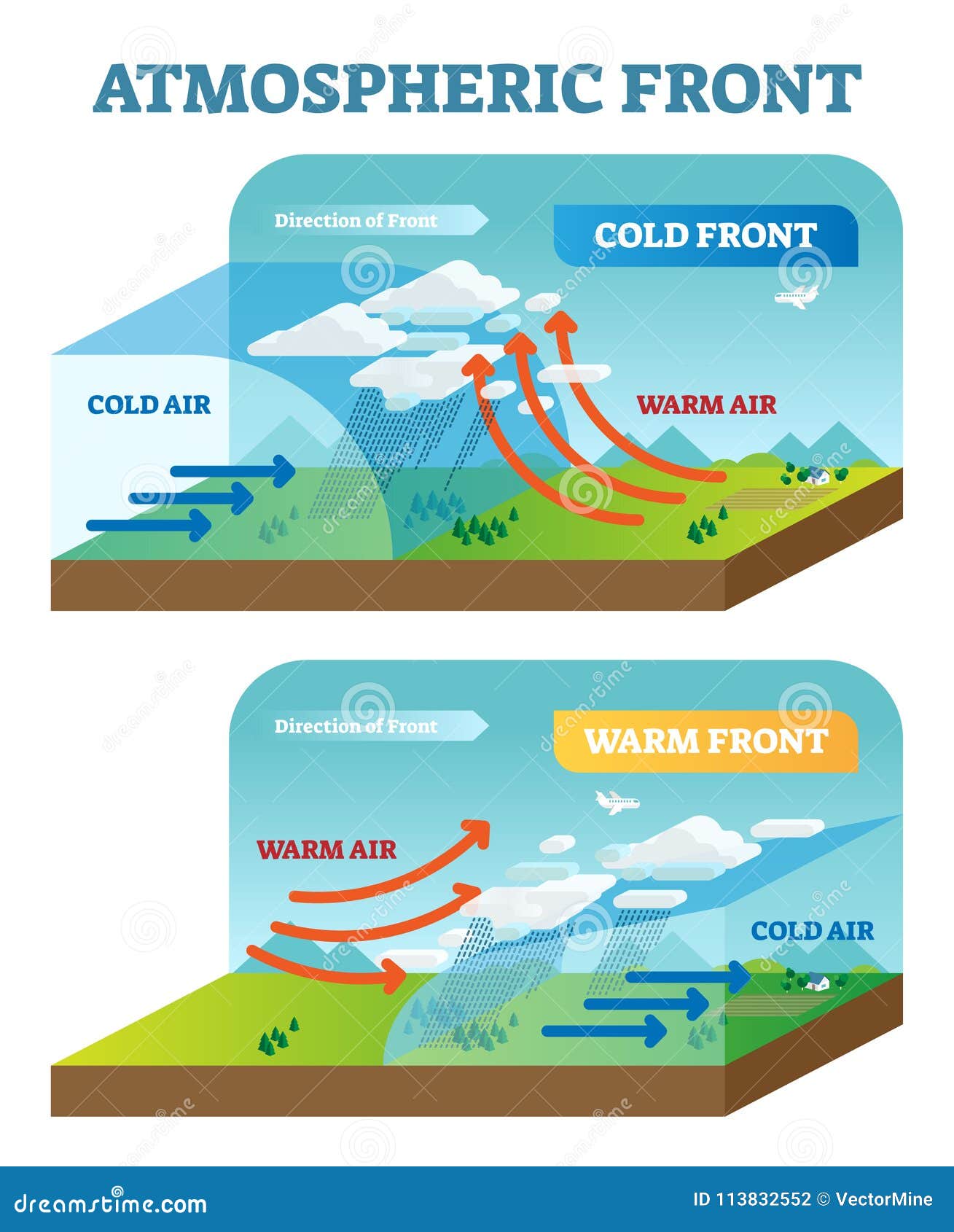
- Cold Front (Top Diagram): A cold air mass actively pushes into a warmer air mass. Because the cold air is dense, it acts like a wedge, forcing the warm, moist air ahead of it to rise very quickly and steeply. This rapid uplift often creates a narrow band of towering cumulonimbus clouds, leading to intense, short-lived showers and thunderstorms right along the front.
- Warm Front (Bottom Diagram): A warm air mass advances and encounters a colder, denser air mass that is retreating more slowly. The warm air, being less dense, cannot push the cold air out of the way. Instead, it gently glides up and over the wedge of cold air. This ascent is much more gradual and spread over a wider area. It typically produces broad layers of stratus and nimbostratus clouds, resulting in light-to-moderate, steady, and long-lasting precipitation well ahead of the surface front.
Frontal precipitation is the primary cause of the day-to-day weather changes experienced in the mid-latitudes.
Conclusion
Today, we have explored the three primary atmospheric engines that drive precipitation. While they operate differently, they all achieve the same crucial first step: lifting moist air.
Key Takeaways:
- All precipitation begins with a mechanism that forces air to ascend, causing it to expand, cool adiabatically, and reach saturation.
- Convectional precipitation is caused by the intense surface heating of air, which then rises in buoyant plumes. It is typically localized, heavy, and common in summer and the tropics.
- Orographic precipitation is caused by air being physically forced to rise over a mountain range. This creates a wet windward side and a dry rain shadow on the leeward side.
- Frontal precipitation is caused by the interaction of different air masses. Colder, denser air forces warmer, less dense air to rise, producing widespread and varied weather.
Preview of the Next Lesson:
We've just had a brief introduction to the idea of air masses and fronts. To truly understand weather systems and interpret weather maps, we need to delve deeper. In our next lesson, we will begin a new module by formally defining an air mass, classifying the different types based on their source regions, and preparing to study the structure of weather fronts in detail.