Hello! Welcome to our next lesson on atmospheric moisture.
In our previous lesson, we explored the fascinating micro-scale physics inside clouds, learning how millions of tiny cloud droplets can grow into precipitation through the Collision-Coalescence and Ice-Crystal (Bergeron) processes. A key takeaway was that most precipitation in mid-latitudes, even summer rain, begins as snow or ice crystals high in the cold regions of clouds.
That sets the stage perfectly for today's topic. If precipitation often starts as snow, why don't we see snow all the time? What determines whether we experience a gentle rain, a heavy snowfall, or a dangerous ice storm?
Today, we will answer these questions. Our learning outcome is to differentiate between types of precipitation, including rain, snow, sleet, and hail. The key to this is understanding the temperature profile of the atmospheric layer between the cloud base and the ground.
A Framework for Precipitation Types
Precipitation is simply water in its liquid or solid phase that falls from the atmosphere to the Earth's surface. We can group the main types by their state of matter when they reach us. The Wikipedia article on "Precipitation types" provides a clear classification that we can use as a mental model.
Let's start by looking at a simple classification of precipitation types based on their phase (liquid, solid, or mixed). This will give us a structured overview before we dive into the details.
Please read the section titled 'Phases'. You don't need to memorize the METAR codes (the letters in parentheses), but notice how precipitation is grouped into Liquid, Freezing/Mixed, and Frozen categories. This is the framework we'll use.
As you saw, the main types are rain, snow, sleet, and hail. The crucial factor that determines which of these forms is the vertical temperature structure of the atmosphere through which the precipitation falls.
The Role of the Atmospheric Temperature Profile
Let's explore the four most common scenarios. A short video from meteorologists at WUSA9 explains the formation of snow, sleet, and freezing rain using a simple but effective animated diagram of the atmosphere's temperature profile.
Types of precipitation explained | Weather 101
This video provides an excellent visual introduction to how different temperature layers in the atmosphere produce different types of winter precipitation. Focus on how the presence and thickness of a warm layer aloft is the critical factor.
Watch the video from the beginning up to 01:16. The meteorologist explains the conditions for snow, then sleet, and finally freezing rain. Pay close attention to the animated diagrams showing the layers of cold and warm air.
Now, let's break down each type systematically, using the concepts from the video and adding more detail.
The image below is a fantastic summary of the four main temperature profiles. We will refer back to it as we discuss each type.

1. Snow
As shown on the far right of the diagram, the formation of snow is the most straightforward.
- Process: Precipitation begins as ice crystals/snowflakes via the Bergeron process in the cloud. It falls through an atmospheric column where the temperature is entirely below freezing (0°C or 32°F).
- Result: The snowflakes reach the ground without melting.
2. Rain
Rain can form in two ways, as depicted on the far left of the diagram.
- Process 1 (Melting Snow): This is very common in mid-latitudes. Precipitation begins as snow, but then falls through a deep layer of warm air that is well above freezing. The snow has ample time to melt completely into raindrops.
- Process 2 (Warm Cloud): In tropical regions or during summer, rain can form in "warm clouds" (entirely above 0°C) via the collision-coalescence process we learned about. The raindrops fall to the ground without ever having been frozen.
3. Sleet (or Ice Pellets)
Sleet occurs when there's a "warm sandwich" effect in the atmosphere, as shown in the diagram.
- Process: Snowflakes fall from the cloud, melt into raindrops as they pass through a shallow layer of warm air, and then fall into a deep layer of cold, sub-freezing air near the surface. This gives the raindrops enough time to refreeze into solid ice pellets before hitting the ground.
- Result: Sleet consists of small, translucent balls of ice that bounce upon impact.
4. Freezing Rain
Freezing rain is arguably the most dangerous type of winter precipitation. Its atmospheric profile is a variation of the sleet profile.
- Process: Snowflakes fall and melt in a deep warm layer, just like in a rain scenario. However, they then fall through a very shallow layer of sub-freezing air right at the surface. The droplets don't have time to refreeze in the air.
- Result: The drops land as supercooled liquid rain and freeze instantly upon contact with any surface that is at or below 0°C (roads, power lines, trees). This creates a smooth, heavy coating of ice called glaze.
For a comprehensive textual summary of these types, let's turn to our next resource.
Rain, Snow, Sleet, and Other Types of Precipitation
The article 'Rain, Snow, Sleet, and Other Types of Precipitation' by ThoughtCo provides clear, written definitions that will reinforce what we've just seen in the video and diagram.
Please read the sections titled 'Rain,' 'Snow,' 'Sleet,' and 'Freezing Rain.' Compare these descriptions to the four profiles in the 'Precipitation Types Formation' diagram above.
Test your understanding!
You are a meteorologist analyzing an atmospheric temperature sounding. The precipitation is starting as snow high up in the clouds.
- Scenario A: The snow falls through a deep layer of air with a temperature of -5°C all the way to the ground. What will you forecast?
- Scenario B: The snow falls through a layer of air at +3°C that is 1000 meters thick, then enters a final 100-meter layer of air at -2°C just before hitting the ground. What is the most likely precipitation type? Why?
Show answer
- Scenario A: You would forecast snow. The temperature is below freezing throughout the entire path, so the snowflakes will not melt.
- Scenario B: The most likely precipitation type is freezing rain. The snow will melt completely in the deep warm layer (+3°C). The final cold layer (-2°C) is very shallow (only 100 meters), which is not enough time for the raindrops to refreeze into sleet. Therefore, they will land as liquid water and freeze on contact with the cold ground.
Differentiating Hail, Sleet, and Graupel
The solid forms of precipitation can be confusing. We've already covered sleet, but how is it different from hail or another form called graupel? The key difference is their formation process.
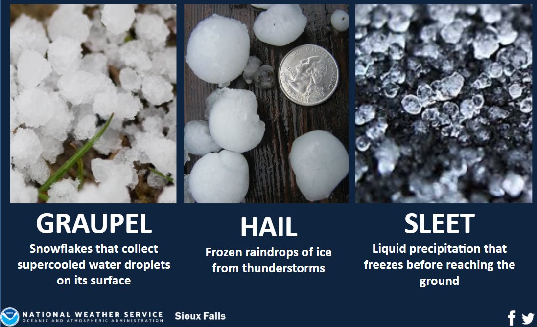
Let's break them down.
Hail
Hail is exclusively a product of severe thunderstorms (Cumulonimbus clouds), not gentle winter weather.
- Process: Strong updrafts within a thunderstorm repeatedly carry raindrops upward into the extremely cold regions of the cloud, where they freeze. They fall, collect more liquid water, and are swept up again. This cycle adds layers of ice, much like an onion, until the hailstone is too heavy for the updraft to support and it falls to the ground.
- Result: Hailstones are hard balls of ice that can range from pea-sized to larger than a grapefruit. They are associated with property damage and are a warm-season phenomenon.
Graupel (or Snow Pellets)
Graupel is something of a hybrid between a snowflake and a hailstone.
- Process: A falling snowflake collides with supercooled water droplets (liquid water below 0°C), which freeze onto the surface of the snowflake in a process called riming.
- Result: This process obscures the original delicate structure of the snowflake, forming an opaque, soft, and crumbly pellet that resembles a tiny Styrofoam ball. Graupel is sometimes called "soft hail."
Now, let's complete our reading to solidify the distinctions between these icy forms.
Rain, Snow, Sleet, and Other Types of Precipitation
Let's return to the ThoughtCo article to read the official definitions for hail and graupel. Pay close attention to how their formation mechanisms are completely different from that of sleet.
Please read the sections titled 'Graupel' and 'Hail'. Note that hail forms in thunderstorms, while graupel is essentially a heavily coated snowflake.
Summary
To bring all this together, here is a summary table that contrasts the main precipitation types.
| Precipitation Type | Formation Process | Atmospheric Temperature Profile During Fall | Appearance & Characteristics |
|---|---|---|---|
| Rain | Begins as snow and melts, OR forms as liquid drops in a warm cloud. | Deep warm layer melts snow, OR entire column is above freezing. | Liquid water droplets. |
| Snow | Forms as ice crystals in a cold cloud via the Bergeron process. | Entire column from cloud to ground is below freezing (0°C). | Crystalline ice flakes. |
| Sleet | Begins as snow, melts into rain in a warm layer, then refreezes into ice pellets before hitting the ground. | "Warm Sandwich": Cold -> Shallow Warm -> Deep Cold. | Small, translucent, solid ice pellets. Bounces on impact. |
| Freezing Rain | Begins as snow, melts completely into rain, but becomes supercooled in a shallow layer of cold air at the surface. | "Inverted Sandwich": Cold -> Deep Warm -> Shallow Cold. | Falls as liquid; freezes on contact with sub-freezing surfaces. |
| Hail | Forms by accretion in the violent updrafts and downdrafts of a thunderstorm. | Occurs within a Cumulonimbus cloud; not dependent on surface temperature profile. | Hard, layered balls of ice, from pea-sized to very large. |
| Graupel | A snowflake collides with and is coated by supercooled water droplets (riming). | Occurs within a cold cloud. | Soft, opaque, crumbly pellets of ice. "Soft hail". |
Conclusion
Today, we've seen that the journey of precipitation from a cloud to the ground is critical. The same snowflake that starts high in the atmosphere can reach the ground as snow, rain, sleet, or freezing rain, all depending on the temperature of the air it travels through. We also clearly distinguished these types from hail, which is a product of a completely different and more violent process within thunderstorms.
Key Takeaways:
- The vertical temperature profile of the atmosphere is the primary factor determining the type of precipitation that reaches the surface.
- Snow requires the air to be below freezing from the cloud to the ground.
- Rain occurs when snow melts in a deep warm layer or when it forms in a warm cloud.
- Sleet and Freezing Rain are both caused by a temperature inversion (a layer of warm air above colder air), but the thickness of the cold layer near the ground determines the outcome.
- Hail is fundamentally different; it is formed by powerful, cycling updrafts within thunderstorms and is not a "wintry mix" phenomenon.
Preview of the Next Lesson:
We now understand how precipitation forms in clouds and how its type is determined on its way down. But what causes the air to rise and form these precipitation-producing clouds in the first place? In our next lesson, we will zoom out to a larger scale and analyze the mechanisms of conventional, orographic, and frontal precipitation, linking our knowledge of clouds and rain to the dynamics of weather systems.