Hello! Let's dive into the next fascinating step in our journey through the atmosphere.
In our last lesson, we learned to identify the ten major cloud types and saw that some, like Nimbostratus and Cumulonimbus, are precipitation-producers. This raises a crucial question: clouds are made of countless tiny water droplets and ice crystals that are light enough to float, so how do they transform into raindrops or snowflakes heavy enough to fall to Earth?
Today, we will answer that question. Our learning outcome is to explain the primary mechanisms of precipitation formation within clouds. We will explore the two main "recipes" the atmosphere uses to create precipitation: one for "warm" clouds and one for "cold" clouds. Understanding these processes is fundamental to climatology and explains why different clouds produce everything from light drizzle to heavy snow.
The Scale of the Problem: From Cloud Droplet to Raindrop
Before we explore the solutions, it's important to appreciate the scale of the challenge. A typical cloud droplet is minuscule, about 20 micrometers (0.02 mm) in diameter. A typical raindrop is about 2 millimeters in diameter—100 times larger. Because of this difference in radius, a single raindrop contains the same amount of water as roughly one million cloud droplets!
Simple condensation, the process that forms the cloud droplets in the first place, is far too slow to create particles of this size in the lifespan of a cloud. The atmosphere needs more efficient mechanisms.
First, let's use a textual resource to solidify our understanding of why a special process is needed. This article from LibreTexts clearly explains the size difference between a cloud droplet and a raindrop and states why simple condensation isn't enough.
Please read the introduction and the section titled 'Raindrops'. You can skim the equations; the key is to focus on the core concept discussed in the text: it takes about 1 million cloud droplets to make one raindrop, and a faster process than condensation is required for this to happen.
Now that we see the problem, let's look at the two solutions nature has devised.
1. The Collision-Coalescence Process (The "Warm Cloud" Recipe)
The first and simpler mechanism occurs in "warm clouds"—those that exist at temperatures entirely above freezing (0°C). This process is dominant in the tropics but also occurs in the lower portions of summer clouds in mid-latitudes. As its name suggests, it involves cloud droplets colliding and merging.
The Collision-Coalescence process is exactly what it sounds like: droplets bump into each other and stick together. The LibreTexts article provides a concise explanation of how this works.
Now, read the section 'Collision-Coalescence Process' in the same article. Pay close attention to the key ingredients for this process to be effective: a mixture of different droplet sizes, significant cloud thickness, and upward air currents (updrafts).
In essence, the process works like this:
- Cloud droplets are not all the same size. Larger droplets fall slightly faster than smaller ones.
- As a larger droplet descends, it collides with smaller, slower-moving droplets in its path.
- When they collide, they can coalesce (merge) into an even larger droplet.
- This new, larger droplet falls even faster, sweeping up more small droplets in a chain reaction, growing rapidly until it is heavy enough to fall from the cloud as a raindrop.
Strong updrafts in a cloud, like those in a tall cumulus cloud, can keep a droplet suspended for a longer time, giving it more opportunities to collide and grow before it finally falls. This is why thick, turbulent clouds produce much heavier rain than thin, stable stratus clouds.
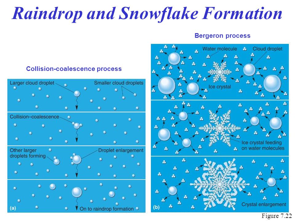
2. The Ice-Crystal Process (The "Cold Cloud" Recipe)
Outside of the tropics, most precipitation—even summer rain—begins through a more complex mechanism known as the Ice-Crystal Process, or the Bergeron Process. This occurs in "cold clouds" where the temperature is below 0°C.
These clouds contain a mixture of two fascinating components: tiny ice crystals and supercooled water—liquid water droplets that remain in a liquid state even at temperatures below freezing.
To understand this process, we first need to grasp the idea of supercooled water.
This second mechanism is responsible for most of the precipitation in our latitudes. To understand it, we must first learn about 'supercooled water' and the 'ice nuclei' that help it freeze. The LibreTexts article explains these concepts clearly.
Read the section 'Ice Phase Process' up to (but not including) the sub-section 'Saturation Vapor Pressure'. Focus on the definitions of supercooled water and ice nuclei.
The key to the Ice-Crystal process is this: At sub-freezing temperatures, water vapor molecules are more strongly attracted to ice crystals than to liquid water droplets.
This means that in a cloud where ice crystals and supercooled water droplets coexist, the ice crystals will grow at the expense of the water droplets.
Ch. 5 - Bergeron Process & Collision/Coalescence Process
This concept of water vapor preferring ice over liquid can be tricky. This video by Dr. Gigi Richard provides an excellent analogy to explain why this happens. It's the core of the Bergeron Process.
Please watch the video from 00:11 to 04:25. Pay close attention to the 'two chambers' analogy (starting around 01:25). It powerfully demonstrates why water vapor molecules move from the liquid droplets to the ice crystals, causing the crystals to grow while the droplets evaporate.
This phenomenon occurs because the saturation vapor pressure is lower over an ice surface than over a water surface at the same sub-freezing temperature. In simple terms, it's "easier" for water vapor to become solid ice than to stay as vapor around a liquid droplet.
So, the process unfolds in these steps:
- A cold cloud contains a vast number of supercooled liquid droplets and a few rare ice crystals.
- Water vapor molecules leave the liquid droplets (evaporation) and are readily deposited onto the ice crystals.
- The ice crystals grow rapidly, while the supercooled droplets shrink and disappear.
- These growing ice crystals become heavy, and they may grow even larger by colliding with other ice crystals (aggregation) or with supercooled droplets that freeze on contact (riming).
- Eventually, they become large enough to fall from the cloud as snowflakes.
If the air below the cloud is below freezing all the way to the ground, they land as snow. If they fall through a layer of air that is above freezing, they melt and land as rain. This is why a gentle summer shower in a place like New York or London likely began as snow high up in the atmosphere!

Test your understanding!
Imagine two scenarios:
- A thin, low-lying stratus cloud forms over the warm tropical ocean near the equator.
- A very tall, vertically-developed cumulonimbus cloud forms over North America in July.
Which precipitation process (Collision-Coalescence or Ice-Crystal) would be primarily responsible for producing rain in each scenario, and why?
Show answer
- In the tropical stratus cloud, the entire cloud is likely warmer than 0°C. Therefore, the Collision-Coalescence process would be the only mechanism available to produce precipitation (likely a light drizzle, given the cloud's thinness).
- In the tall cumulonimbus cloud, both processes would be at work. Collision-Coalescence would occur in the lower, warmer parts of the cloud. However, since the cloud is tall enough to extend well above the freezing level, the Ice-Crystal process would be dominant in the upper, colder regions. This process is much more efficient and is responsible for the heavy rainfall associated with thunderstorms. The precipitation would start as ice/snow high up and melt into heavy rain as it falls through the warmer air below.
Conclusion
Today we've uncovered the secrets of how clouds make rain and snow. We've moved from the macroscopic world of cloud shapes to the microscopic physics happening within them.
Key Takeaways:
- Cloud droplets are too small and light to fall as rain; they must grow about a million times in volume first.
- The Collision-Coalescence Process is the primary mechanism in "warm clouds" (above 0°C). Larger droplets fall and sweep up smaller ones, merging to form raindrops.
- The Ice-Crystal (Bergeron) Process is the dominant mechanism in "cold clouds" (below 0°C), especially in mid- and high-latitudes.
- This process works because water vapor is more attracted to ice than to supercooled liquid water, causing ice crystals to grow at the expense of water droplets.
- Much of the rain that falls in temperate climates, even in summer, begins as snow high within the clouds and melts on its way down.
Preview of the Next Lesson:
We've seen how precipitation forms and that it can start as either liquid or solid. In our next lesson, we will focus on what happens as it falls to the ground. We will differentiate between types of precipitation, including rain, snow, sleet, and hail, examining the atmospheric temperature conditions that create these different forms.