Hello! Welcome back to our study of atmospheric moisture.
In our last lesson, we saw how condensation creates dew, frost, and fog near the ground. We also introduced the basic framework for classifying clouds using their height and form (cirrus, cumulus, stratus). You learned that this system provides a powerful way to "read" the sky.
Today, we will build directly on that foundation. Our goal is to classify the major cloud types and relate them to the weather conditions they bring. By the end of this lesson, you will be able to look at the sky, identify the ten principal cloud types, and make an educated guess about the current and near-future weather. This is a classic skill in geography and meteorology, and it's a fantastic way to connect with the atmospheric processes we've been learning about.
The Language of the Clouds
Before we start identifying individual clouds, it's essential to understand the "language" used to name them. As we briefly touched on last time, cloud names are derived from five Latin root words that describe their appearance, altitude, or function. Mastering these building blocks will make classification much more intuitive.
Cloud Identification Guide: Cloudspotting 101
The article 'Cloud Identification Guide: Cloudspotting 101' provides a superb breakdown of the five Latin terms that form the basis of all cloud names. Understanding these will give you a system for decoding cloud types rather than just memorizing them.
Please read the section titled 'The 5 Latin Terms of Cloud Types'. Focus on understanding the meaning of each term and the cloud characteristics it describes.
Let's quickly summarize those key terms:
- Cirro- (curl): Refers to high-altitude clouds, which are thin, wispy, and composed of ice crystals.
- Cumulo- (heap): Describes puffy, cotton-like clouds with distinct vertical development.
- Strato- (layer): Denotes flat, featureless clouds that form in broad sheets or layers.
- Nimbo- (rain): A prefix or suffix indicating that a cloud is producing precipitation.
- Alto- (high): Used as a prefix for mid-level clouds. It signifies they are higher than their low-level counterparts (e.g., altocumulus are higher than cumulus).
With this framework in mind, we can now explore the ten main cloud genera that are formed by combining these terms.
A Visual Guide to the Ten Cloud Types
The best way to learn clouds is to see them. We are now going to watch a detailed lecture that provides excellent visual examples of each cloud type, explaining how to distinguish them based on their appearance, height, and other key features.
Lecture 1: How to identify and name clouds (introduction to weather)
The video 'How to identify and name clouds' by Mel Strong is a comprehensive visual tutorial. It systematically breaks down the 10 cloud types by shape and height, offering numerous examples and helpful tips for identification.
Please watch the video from the beginning until 25:43. I recommend watching it in the following segments, perhaps pausing to take notes on each cloud type's appearance and weather association. Introduction & System (0:00 - 07:03): This reviews the classification system based on shape (cumuliform, stratiform, cirriform) and height (low, middle, high). Cumuliform Clouds (07:03 - 20:25): Covers Cumulus, Altocumulus, Cirrocumulus, Stratocumulus, and the precipitation-producing Cumulonimbus. Stratiform & Cirriform Clouds (20:25 - 25:43): Covers Stratus, Nimbostratus, Altostratus, Cirrostratus, and Cirrus. The final part of the video (after 25:43) discusses some fascinating special cloud types (Lenticular and Mammatus), which you are welcome to watch if you're curious!
Consolidating Your Knowledge
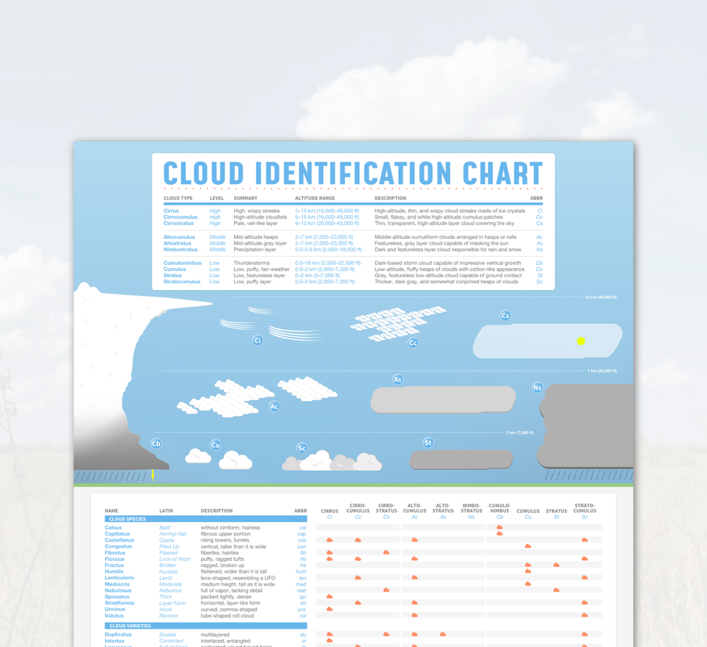
That video provided a wealth of visual information. To help organize it all, let's use a reference chart. This chart summarizes the ten main cloud types, their altitudes, and their key characteristics in a single image. It's a great tool to have handy as you practice your cloud-spotting skills.
Relating Clouds to Weather
As you saw in the video, each cloud type is a clue about the state of the atmosphere. Now, let's explicitly link the major cloud types to the weather conditions they typically signify.
1. Fair Weather Clouds
These clouds are generally associated with stable, calm weather.
- Cumulus (Cu): Detached, puffy clouds with flat bases. Often called "fair-weather cumulus," they indicate pleasant conditions. However, if they start growing vertically, they can develop into storm clouds.
- Cirrus (Ci): Thin, wispy, and made of ice crystals. They signal fair weather in the short term, but because they often form ahead of an approaching warm front, they can sometimes indicate a change in weather is coming within 24-48 hours.
- Cirrocumulus (Cc): Small, white patches of clouds arranged in a rippling pattern. They are uncommon and typically indicate fair but cold weather.
2. Overcast & Gloomy Clouds
These clouds often cover the entire sky, creating a dull, gray appearance.
- Stratus (St): A gray, featureless layer that looks like high fog. Associated with dreary, overcast days and can produce light mist or drizzle.
- Stratocumulus (Sc): Low, lumpy layers or patches of gray to whitish clouds with blue sky visible between them. Usually do not produce precipitation, but can sometimes yield very light rain.
3. Clouds of Impending Change
These mid-level clouds often signal an approaching weather system.
- Altostratus (As): A grayish or bluish sheet of cloud that partially or totally covers the sky. The sun may be visible through it as if viewed through ground glass (sometimes called a "watery sun"). They often form ahead of a warm front that will bring widespread precipitation.
- Altocumulus (Ac): White or gray patches that look like "sheep's back" or "mackerel sky." If seen on a warm, humid morning, they can signal the development of thunderstorms later in the day.
4. Precipitation Clouds
The name says it all—when you see these, expect rain or snow. The key difference is the type of precipitation.
- Nimbostratus (Ns): A thick, dark gray layer that blots out the sun. They are the classic storm clouds of steady, prolonged precipitation (rain or snow) over a wide area. You can't see the boundaries of the rain.
- Cumulonimbus (Cb): The king of clouds. These are towering thunderstorm clouds that span all three height levels. They bring heavy, intense, and showery precipitation, including rain, hail, and snow, often accompanied by lightning and thunder. They are characterized by a dark base and a fibrous "anvil" top.
Test your understanding!
You are on a hike. In the morning, the sky is dotted with small, puffy, fair-weather cumulus clouds. By early afternoon, you notice these clouds are growing much taller, their bases are getting darker, and their tops are becoming fibrous and spreading out into an anvil shape. What cloud type are you now seeing, and what change in weather should you prepare for?
Show answer
The clouds are developing into Cumulonimbus (Cb). The vertical growth and the formation of an anvil top are classic signs of a developing thunderstorm. You should prepare for severe weather, including heavy rain, potential hail, strong winds, and lightning, and seek shelter immediately.
Conclusion
Congratulations! You have now learned the internationally recognized system for classifying clouds. By understanding the Latin roots and combining them with observations of shape and height, you can identify the ten major cloud types. More importantly, you've learned that these beautiful formations are not random; they are direct visual manifestations of atmospheric processes.
Key Takeaways:
- Cloud names are built from five Latin roots: cirro- (high/wispy), cumulo- (heap), strato- (layer), nimbo- (rain), and alto- (mid-level).
- The ten primary cloud types are classified by their altitude (high, middle, low) and form.
- High clouds (Cirrus, Cirrocumulus, Cirrostratus) are made of ice and are generally thin and wispy.
- Middle clouds (Altocumulus, Altostratus) can indicate approaching weather changes.
- Low clouds (Stratus, Stratocumulus, Cumulus) range from fair-weather puffballs to dreary gray sheets.
- Precipitation clouds are Nimbostratus (for steady, widespread rain) and Cumulonimbus (for heavy, convective storms).
Preview of the Next Lesson:
We've identified the clouds that produce precipitation, namely Nimbostratus and Cumulonimbus. But how do tiny cloud droplets or ice crystals grow large enough to fall to the Earth? In the next lesson, we will explore the primary mechanisms of precipitation formation to understand the microphysics occurring inside these clouds that lead to rain and snow.