Hello! Welcome back to our course on the foundations of cartography.
In our last lesson, we learned to differentiate between various types of maps, understanding that a map's design is driven by its purpose—whether it's for general reference (like a political or physical map) or to tell a story about data with a thematic map.
Now that we can identify a map's purpose, we need to address a fundamental question: how does a small drawing on a piece of paper or screen relate to the vastness of the real world? Answering this brings us to one of the most critical concepts in all of cartography.
Today, our learning outcome is to explain the concept of map scale and calculate real-world distances from a map. This skill is the bridge between the map as an object and the geographic reality it represents.
1. What is Map Scale?
At its heart, map scale is a simple idea. Since we can't create maps that are the same size as the Earth, cartographers must shrink everything down. The scale tells us exactly how much it has been shrunk.
Map scale is the relationship, or ratio, between a distance on a map and the corresponding distance on the ground.
Let's begin with a short video that introduces this core concept.
Y11-12 Geography: Scale and Distance on Maps
This video from Atomi, 'Y11-12 Geography: Scale and Distance on Maps,' provides a quick and clear definition of map scale.
Please watch the first 47 seconds of the video. Focus on the core definition of map scale as a relationship between map features and their real size.
As the video explained, this relationship can be expressed in three main ways on a map.
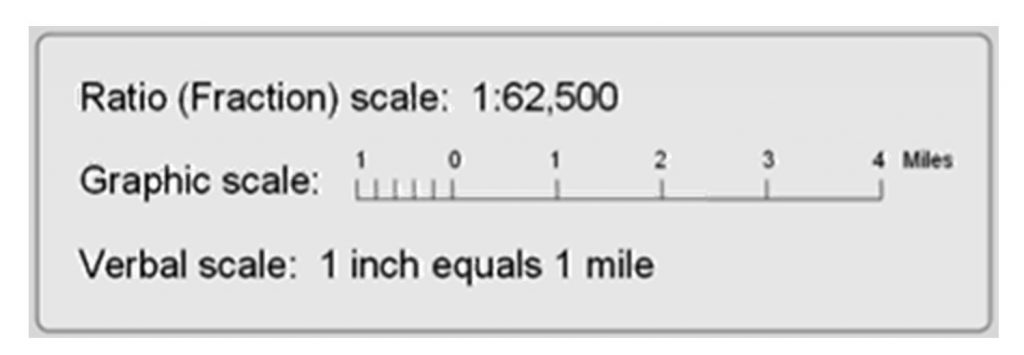
Let's look at each of these in more detail.
Map Scale - Representative Fraction, Bar Scale and Verbal ...
The article 'Map Scale' from Small Farm Link offers clear, concise explanations of these three types of scales. We'll use it to solidify our understanding.
Please read the three sections titled 'Verbal Scale:', 'Representative Fraction (RF) - Fractional Scale - Ratio Scale:', and 'Bar Scale - Graphic Scale - Linear Scale:'. Pay attention to how each one defines the relationship between map and ground distance.
To summarize your reading:
- Verbal Scale: A straightforward statement, like "1 centimeter represents 500 meters." It's easy to understand but can become invalid if the map is resized.
- Representative Fraction (RF) or Ratio Scale: Written as a ratio, like
1:50,000or1/50,000. This means one unit of any measurement on the map equals 50,000 of the same unit on the ground. This is the most versatile type of scale because it is unit-less.1 inchon the map is50,000 incheson the ground, just as1 cmon the map is50,000 cmon the ground. - Graphic Scale or Bar Scale: A visual ruler printed on the map. This allows you to measure distances directly without calculations. Its major advantage is that it remains accurate even if the map is photocopied, scanned, or resized.
2. Large Scale vs. Small Scale: A Point of Confusion
You will often hear geographers talk about "large-scale" and "small-scale" maps, and the terminology can be counterintuitive. Let's clarify this.
- A Large-Scale Map shows a small area with a large amount of detail. The RF is a "larger" fraction (e.g.,
1:25,000is a larger number than1:1,000,000). Think of a detailed city street map. - A Small-Scale Map shows a large area with less detail. The RF is a "smaller" fraction (e.g.,
1:1,000,000). Think of a world map.
The following video explains this common point of confusion very well.
Y11-12 Geography: Scale and Distance on Maps
Let's return to the Atomi video, which has an excellent segment clarifying the difference between large- and small-scale maps.
Please watch from 02:15 to 03:03. The key is to connect 'large scale' with a 'large amount of detail.'
3. Calculating Straight-Line Distance
Now for the practical application. How do we use scale to find the actual distance between two points? This is often called the "as the crow flies" distance—a direct, straight line.
The process is a simple, three-step calculation.
- Measure: Use a ruler to measure the distance between the two points on the map.
- Multiply: Multiply your measured distance by the scale's denominator (if using an RF scale).
- Convert: Convert the result into a more practical unit (e.g., from centimeters to kilometers).
Let's watch a clear demonstration of this process.
Y11-12 Geography: Scale and Distance on Maps
The Atomi video provides a perfect, step-by-step walkthrough of calculating a straight-line distance using a ruler and a ratio scale.
Please watch from 03:50 to 05:06. Follow the example closely: measure, multiply by the scale, and convert the units.
Here is a static image showing the same process.

Key Conversion Factors to Remember:
- 100 centimeters = 1 meter
- 1,000 meters = 1 kilometer
- Therefore, 100,000 centimeters = 1 kilometer
Test your understanding!
You are using a topographic map with a scale of 1:50,000. You measure the straight-line distance between your campsite and a mountain peak to be 6.5 cm on the map. What is the actual distance in kilometers?
Show answer
- Measure: The map distance is 6.5 cm.
- Multiply: 6.5 cm × 50,000 = 325,000 cm.
- Convert: 325,000 cm / 100,000 cm/km = 3.25 km.
The actual distance is 3.25 kilometers.
4. Measuring Curved Distances
Real-world travel rarely happens in straight lines. We follow winding roads, meandering rivers, or curving hiking trails. Measuring these distances on a map requires an extra step.
The basic idea is to transfer the curved path on the map to a straight line that you can then measure. This can be done with a piece of string or, often more accurately, with the edge of a strip of paper.
This next video gives an excellent demonstration of measuring a curved path using a strip of paper, which is a very reliable technique.
How to read Maps - Scale and Distance (Geography skills)
This video from Geographer Online, 'How to read Maps - Scale and Distance,' demonstrates two methods for measuring non-straight paths, with a particularly clear tutorial on using a strip of paper.
Please watch from 04:38 to 07:15. Pay close attention to how the presenter uses a strip of paper, pivoting and marking small, straight sections to trace the curved road.
Once you have the total length of the curved path (either from your string or paper strip), the calculation is exactly the same as for a straight line: multiply that length by the scale factor and convert your units.
A Final Practical Note
When you use digital maps or make photocopies, the map image can be enlarged or shrunk. If this happens:
- A Verbal Scale ("1 cm = 1 km") becomes incorrect.
- A Ratio Scale (1:100,000) becomes incorrect.
- A Graphic/Bar Scale remains correct, because the bar shrinks or grows along with the rest of the map.
This is why graphic scales are so important and are almost always included on maps. They are the most reliable form of scale when a map's size may have been altered.
Conclusion
Today, we've unraveled the concept of map scale and turned it into a practical tool. You now have the ability to look at any map and translate the distances you see into their real-world equivalents.
Key Takeaways:
- Map scale is the ratio between map distance and ground distance.
- It's expressed in three ways: Verbal (in words), Representative Fraction (a ratio like 1:50,000), and Graphic (a bar scale).
- Large-scale maps show a small area in great detail, while small-scale maps show a large area with less detail.
- To calculate real-world distance, you measure the distance on the map, multiply by the scale factor, and convert to appropriate units.
- Curved paths, like roads or rivers, can be measured using a piece of string or a strip of paper before applying the scale calculation.
Preview of the Next Lesson:
We've learned to identify map types and understand their scale. The next piece of the puzzle is to decipher the language of the map itself. In our next lesson, we will focus on how to interpret standard map symbols, colors, and legend elements to extract information. This will allow you to read the rich detail that cartographers pack into every map.