Hello! Welcome to our next lesson on weather systems.
In our last session, we identified the four basic types of fronts: cold, warm, stationary, and occluded. We learned that a front is a boundary between different air masses and that each type has a unique structure. Today, we will build directly on that knowledge to fulfill our learning outcome: to analyze the typical weather patterns and precipitation associated with the passage of a front.
This means we're moving from what a front is to what it feels like to experience one passing over your location. We will trace the sequence of changes in clouds, precipitation, temperature, and air pressure. You'll see how the physical structure of each front, which we discussed last time, directly causes a predictable chain of weather events. This is a fundamental skill for interpreting weather maps and understanding daily forecasts.
1. The Tale of Two Slopes: Why Fronts Behave Differently
The primary difference between the weather of a warm front and a cold front comes down to the slope of the frontal boundary. Let's visualize this.
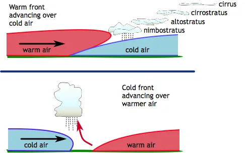
- Warm Front (Top): A warm air mass slides up and over a colder, denser air mass. The slope is very gentle, often rising only 1 km for every 200 km of horizontal distance. This gradual lifting leads to widespread, layered clouds and prolonged, gentle precipitation.
- Cold Front (Bottom): A dense cold air mass acts like a bulldozer, aggressively forcing warmer, lighter air to rise rapidly. The slope is much steeper, sometimes rising 1 km for every 50 km horizontally. This abrupt, powerful lifting creates vertically developed clouds and intense, short-lived weather.
Keep this visual in mind as we now explore the specific sequence of weather for each front.
2. Experiencing a Warm Front Passage
Let's imagine you are standing on the ground as a warm front approaches. What would you observe? The following video provides a detailed, step-by-step account.
Lecture 9: Introduction to fronts and midlatitude cyclones
This segment from a lecture by Mel Strong at Northland College details the entire sequence of events during a warm front's passage. It explains how the gentle slope creates a predictable succession of cloud types and steady precipitation.
Please watch the video from 11:36 to 21:03. As you watch, take note of the order in which the different cloud types appear and how the weather changes as the front gets closer and finally passes.
As the video explained, the passage of a warm front is a slow, drawn-out affair. Here is the typical sequence of events:
- Far Ahead of the Front (12-48 hours before): The first signs are high, wispy cirrus clouds in the sky. As the front advances, these thicken into a transparent white sheet of cirrostratus, often producing a halo around the sun or moon.
- Closer to the Front (6-12 hours before): The cloud deck lowers and thickens to gray altostratus. The sun becomes watery and dim, as if viewed through ground glass.
- At the Frontal Boundary: The clouds become a low, dark, uniform layer of nimbostratus. Light-to-moderate precipitation begins. This precipitation is typically steady and can last for many hours, even a full day.
- Behind the Front: After the front passes, the precipitation stops. The sky may remain overcast with stratus clouds, but can also start to clear. You are now in the warm air mass, so the temperature and humidity are noticeably higher than before.
Throughout this entire approach, the barometric pressure steadily falls.
3. Experiencing a Cold Front Passage
The passage of a cold front is a much more dramatic and fast-moving event. Let's see how it compares.
Lecture 9: Introduction to fronts and midlatitude cyclones
We'll return to the same lecture to see the contrasting experience of a cold front. Notice how the steep 'wedge' of cold air produces weather that is intense but concentrated in a narrow band.
Now, watch from 21:03 to 24:48. Focus on the type of clouds that form, the nature of the precipitation, and the abrupt changes in temperature and dew point.
In sharp contrast to a warm front, a cold front's passage is abrupt and intense:
- Just Ahead of the Front: The weather can be warm and humid. As the front approaches, you'll see the rapid vertical growth of cumulus clouds into towering cumulonimbus (thunderstorm) clouds.
- At the Frontal Boundary: The front arrives with a narrow band of heavy showers and thunderstorms. The precipitation is intense but usually brief, lasting from minutes to a few hours. High winds are common, and in strong fronts, hail or tornadoes are possible.
- Behind the Front: As the front passes, the weather changes rapidly. The temperature and dew point drop sharply—it feels much colder and drier. The wind shifts, often from a southerly to a northwesterly direction (in the Northern Hemisphere). The precipitation stops, and the skies clear quickly.
Barometric pressure drops as the front approaches, hits its lowest point as the front passes, and then rises sharply in the colder, denser air behind it.
Test your understanding!
You are observing the sky. You see a distinct halo around the moon. Over the next several hours, the sky becomes fully overcast, and a gentle, steady rain begins to fall.
- What type of front is most likely approaching?
- What changes in temperature and air pressure would you expect to observe over the next 24 hours?
Show answer
- This is a classic signature of an approaching warm front. The halo is caused by cirrostratus clouds, which are the precursors to the lower, thicker altostratus and nimbostratus clouds that bring steady precipitation.
- You would expect the air pressure to continue falling until the front passes, and then level off. The temperature, which would be cool during the rain, will rise noticeably after the front and the precipitation have passed, as you will then be in the warmer air mass.
4. The Full Picture: Passage of a Mid-Latitude Cyclone
Warm and cold fronts are not isolated events. They are typically integral parts of a larger weather system called a mid-latitude cyclone. This is the primary weather-maker in the mid-latitudes (where much of the world's population lives). Understanding its passage is key to understanding day-to-day weather changes.
The following extended video segment walks through the entire life cycle of a mid-latitude cyclone and, most importantly, provides a detailed narrative of what a person on the ground would experience as the full system passes over them. This is the core of today's lesson, as it combines everything we've learned into a single, coherent story.
Lecture 9: Introduction to fronts and midlatitude cyclones
This is the most important segment for today's lesson. It synthesizes the passages of both a warm and a cold front into the context of a complete weather system. The narrator's step-by-step description is an excellent way to consolidate your understanding.
Please watch from 25:48 to 45:00. This is a longer segment, so I recommend taking notes. Try to create a timeline of events from the perspective of the 'person on the horse.' Pay attention to the sequence of: Cloud types Precipitation (and its character) Pressure changes ('barometer is falling/rising') Temperature and wind changes The 'break' in weather between the two fronts.
Let's summarize that fantastic narrative. The passage of a typical mid-latitude cyclone creates a multi-day weather sequence:
| Stage | Weather Experience |
|---|---|
| 1. Approaching Warm Front | Cirrus clouds appear, thickening to cirrostratus, then altostratus. Pressure begins to fall. |
| 2. Warm Front Passage | Nimbostratus clouds bring long, steady rain or snow. Temperatures are cool. Pressure continues to fall. |
| 3. In the Warm Sector | Rain ends, skies may partly clear. It becomes warm and humid. Pressure is low but steady. This is the "break" between fronts. |
| 4. Approaching Cold Front | Cumulonimbus clouds build rapidly. A line of heavy showers or thunderstorms arrives. |
| 5. Cold Front Passage | Intense but brief precipitation. A sharp drop in temperature and humidity. The wind shifts direction. Pressure begins to rise sharply. |
| 6. Behind the Cold Front | Skies clear. It is now significantly colder and drier. Scattered showers or flurries may linger. Pressure continues to rise. |
This entire sequence is beautifully illustrated in the following diagram, which combines a surface map with a vertical cross-section.

5. Weather at Stationary and Occluded Fronts
Finally, let's briefly describe the weather associated with the other two front types.
- Stationary Front: Since the front is not moving, the weather patterns can persist for days. Typically, the warm air still does some gentle overrunning of the cold air, leading to widespread stratiform clouds and light, drizzly precipitation similar to a warm front, but without any progression.
- Occluded Front: As we saw in the video, an occluded front marks the mature, dying stage of a mid-latitude cyclone. It forms when the cold front catches and lifts the warm front entirely off the ground. The weather is complex, often a mix of both frontal types: widespread clouds and precipitation are common, and embedded thunderstorms can occur.
How to read Surface Weather Maps
For a concise written summary of the weather associated with all four fronts, please read the descriptions provided by the National Oceanic and Atmospheric Administration (NOAA).
Read the sections titled 'Cold Front', 'Warm Front', 'Here is an example...', 'Stationary Front', and 'Occluded Front'. The example paragraph is a particularly good summary of a cyclone's passage.
Conclusion
Today we've moved from simply identifying fronts to analyzing the dynamic sequence of weather they produce. By understanding the physical structure of fronts, we can now "read" the story of approaching weather simply by observing the clouds and feeling the changes in temperature and wind.
Key Takeaways:
- Warm Front Passage: A slow progression from high to low clouds (cirrus -> stratus types) with prolonged, steady precipitation, followed by warmer, more humid conditions.
- Cold Front Passage: An abrupt arrival of towering cumulonimbus clouds, intense but short-lived showers or thunderstorms, followed by a rapid drop in temperature and clearing skies.
- Mid-Latitude Cyclone: This is the most common context for frontal passage in our latitudes, creating a predictable sequence: the warm front experience, a brief warm/humid break (the warm sector), and then the dramatic cold front passage.
- Pressure Changes: Air pressure consistently falls as a front approaches a low-pressure center and rises after it passes.
Preview of the Next Lesson:
We have focused heavily on the mid-latitude cyclone today as the main driver of frontal weather. In our next lesson, we will formalize this by exploring its entire life story, from birth to decay. We will explain the life cycle and characteristics of mid-latitude (temperate) cyclones, solidifying our understanding of this crucial weather system.