Hello! Welcome back to our study of weather systems.
In our last lesson, we defined air masses as vast, uniform bodies of air classified by their temperature and moisture (cP, mT, etc.). We ended with a question: what happens when these different air masses meet? As promised, that is exactly what we will explore today.
This lesson addresses the learning outcome: Identify and describe the four basic types of weather fronts (cold, warm, stationary, and occluded). When different air masses collide, they don't mix easily. Instead, they form a boundary, or a "front," which is often a zone of significant weather activity. Understanding these fronts is fundamental to weather forecasting and is a key part of climatology.
1. What is a Weather Front?
The term "front" was first used by Norwegian meteorologists after World War I, who compared the clash of air masses to the battle fronts of the war. It's a fitting analogy, as the boundary between two air masses is a zone of conflict where one air mass advances and the other retreats, creating dynamic weather.
Let's start with a video that introduces this concept and gives a great overview of the four types of fronts we will be discussing.
Weather Fronts Explained - Cold, Warm, Occluded & Stationary - For Student Pilots
This video from Part Time Pilot provides an excellent introduction to weather fronts, explaining the origin of the term and the fundamental concept of air mass boundaries.
Please watch the first 2 minutes and 9 seconds of the video (00:00 - 02:09). Pay attention to: The definition of a front as a boundary between air masses. The idea that weather is most intense where the temperature difference is greatest.
As the video explained, a front is the boundary zone separating two different air masses. Because air masses have different densities (due to temperature and humidity), they resist mixing. When they meet, the less dense (warmer) air is forced to rise over the denser (colder) air. This lifting process cools the rising air, often leading to cloud formation and precipitation.
The four basic types of fronts are cold, warm, stationary, and occluded. Each has a unique symbol used on weather maps.
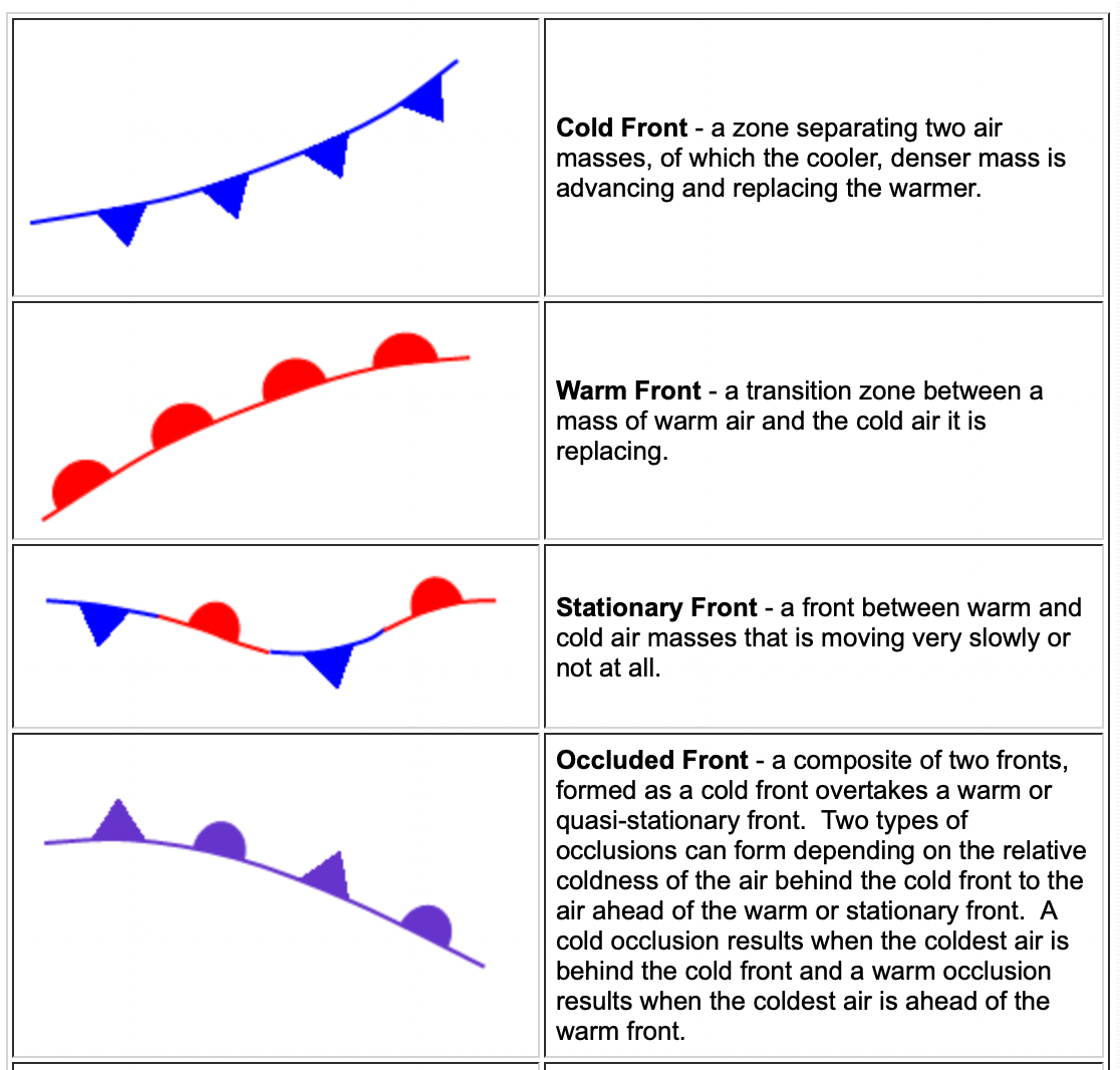
Now, let's look at each of these in detail.
2. Warm Fronts
A warm front occurs when a moving warm air mass advances and replaces a cooler air mass.
Weather Fronts Explained - Cold, Warm, Occluded & Stationary - For Student Pilots
Let's return to the Part Time Pilot video to see how a warm front works.
Watch the segment from 02:09 to 05:22. Focus on: How the less dense warm air rises over the cold air. The gentle slope of the frontal surface. The type of clouds (widespread, stratus-type) and precipitation (light and steady) that form.
The key characteristic of a warm front is its gentle slope. The warm, light air cannot easily push the dense, cold air out of the way. Instead, it slides up and over the cold air mass in a process called overrunning.
This gradual lifting leads to a predictable sequence of clouds that can stretch for hundreds of kilometers ahead of the surface front:
- First, high, wispy cirrus clouds appear.
- These are followed by thicker cirrostratus and then altostratus clouds, which turn the sky a grayish-white.
- Finally, low, thick nimbostratus clouds arrive, bringing widespread, light-to-moderate, and often prolonged precipitation (rain or snow).
Because of this gentle, slow-moving nature, the weather associated with a warm front is typically less violent than a cold front but covers a much wider area.
3. Cold Fronts
A cold front is the opposite: it's the leading edge of a cold air mass that is actively displacing a warmer air mass.
Weather Fronts Explained - Cold, Warm, Occluded & Stationary - For Student Pilots
Now, let's watch the segment on cold fronts. Notice the stark contrast in how the air masses interact compared to a warm front.
Watch from 05:22 to 09:31. Pay close attention to: The 'wedge' analogy for how dense cold air forces warm air up. The steep slope of the front. The resulting vertically developing clouds (cumuliform) and intense weather.
As the video vividly explains, a cold front is an aggressor. The dense, cold air acts like a wedge, forcing the lighter warm air to rise rapidly and steeply.
This powerful vertical uplift leads to very different weather compared to a warm front:
- Clouds: Instead of layered stratus clouds, you get vertically developing cumulus and cumulonimbus (thunderstorm) clouds.
- Precipitation: The weather is concentrated in a narrow band along the front, featuring short but intense showers and thunderstorms. Sometimes, a line of severe thunderstorms called a squall line can form just ahead of the front.
- Speed: Cold fronts typically move faster than warm fronts. After the front passes, the weather usually clears up quickly, leaving behind cooler, drier air.
Test your understanding!
Imagine you are planning an outdoor event. The forecast mentions an approaching front.
- If the forecast calls for a full day of steady, light rain beginning in the morning, what type of front is most likely approaching?
- If the forecast warns of a brief but powerful thunderstorm in the late afternoon, followed by clearing skies and cooler temperatures, what type of front is expected?
Explain your reasoning based on the slope of the front and the resulting air movement.
Show answer
- This scenario suggests a warm front. The gentle slope of a warm front causes slow, widespread lifting, leading to prolonged periods of light, steady precipitation from stratiform clouds.
- This scenario points to a cold front. The steep slope of a cold front acts like a wedge, forcing warm air to rise very rapidly. This creates tall cumulonimbus clouds that produce intense, short-lived thunderstorms. The cool, clear weather afterward is characteristic of the cold air mass that has moved in.
4. Stationary Fronts
What happens when two air masses meet, but neither has enough force to move the other? They form a stationary front.
1.6: Atmosphere- Air Masses and Storms
Let's read a quick description of stationary fronts from the Geo LibreTexts page 'Atmosphere- Air Masses and Storms'.
Please read just the subsection titled 'STATIONARY FRONTS'. Notice how the lack of movement affects the weather.
As the name implies, a stationary front is a stalemate. The two air masses are locked in place.
- Symbol: On a weather map, it's shown with alternating blue triangles pointing into the warm air and red semi-circles pointing into the cold air.
- Weather: The weather can be a mix of conditions found in both warm and cold fronts. Often, gentle overrunning of the warm air over the cold air produces widespread cloudiness and light precipitation (rain, drizzle, fog) that can linger for several days until the front either breaks apart or starts moving again.
5. Occluded Fronts
Occluded fronts are the most complex. They form when a faster-moving cold front "catches up to" and overtakes a slower-moving warm front.
Weather Fronts Explained - Cold, Warm, Occluded & Stationary - For Student Pilots
The final segment of the Part Time Pilot video explains this complex process.
Watch from 09:31 to 13:03. The animation here is key. Focus on how the three air masses (cold, warm, and cool) interact and how the warm air is lifted completely off the ground.
The term occluded means "hidden" or "closed off." In an occluded front, the warm air mass that was caught between the two colder air masses is lifted entirely away from the surface.
This process essentially merges a cold front and a warm front into one system.
- Formation: A cold front (which moves faster) overtakes a warm front.
- Structure: You end up with a cold air mass at the surface, with the lifted warm air mass above it, and another (usually less cold) air mass ahead of it.
- Weather: The weather is a complex mixture of both cold and warm frontal weather. You can find intense, heavy precipitation (like a cold front) along with widespread cloudiness (like a warm front). Occluded fronts are often associated with mature, decaying low-pressure systems.
Conclusion
Today, we've dissected the boundaries where the atmosphere's battles are fought. By understanding how different air masses interact, we can begin to predict the weather that results from their collision.
Key Takeaways:
- A weather front is the boundary between two distinct air masses.
- Warm Fronts have a gentle slope, with warm air sliding over cold air, causing widespread clouds and light, prolonged precipitation.
- Cold Fronts have a steep slope, with cold air wedging under warm air, causing rapid uplift, vertical clouds, and intense, short-lived storms.
- Stationary Fronts are non-moving boundaries where two air masses are at a stalemate, often resulting in lingering cloudy weather.
- Occluded Fronts form when a cold front overtakes a warm front, lifting the warm air mass completely off the ground and creating complex, mixed weather.
Preview of the Next Lesson:
We have now identified and described the four types of fronts. In our next lesson, we will put this knowledge into a practical context. We will analyze the typical weather patterns and precipitation associated with the passage of a front. We'll learn how to look at a weather map and describe the sequence of changes in temperature, wind, and precipitation that you would experience as one of these fronts moves over your location.