Hello! Welcome back to our study of weather systems.
In our last lesson, we took a close look at the weather associated with the passage of cold, warm, stationary, and occluded fronts. We saw that these fronts are not isolated phenomena but are key components of the large, mobile weather systems that dominate the mid-latitudes. You learned to trace the sequence of weather events as a full system passes, from the gentle rains of a warm front to the abrupt, intense storms of a cold front.
Today, we will formalize and expand on that knowledge. Our learning outcome is to explain the life cycle and characteristics of mid-latitude (temperate) cyclones. We will explore the complete "life story" of these systems—from their birth along the polar front, through their mature stage, to their eventual decay. Understanding this cycle is fundamental to meteorology and is central to the climatology of regions like North America, Europe, and much of Asia.
1. What is a Mid-Latitude Cyclone?
A mid-latitude cyclone, also known as an extratropical cyclone or a wave cyclone, is a large-scale, low-pressure system that travels from west to east across the middle latitudes. These cyclones are the primary "weather-makers" for millions of people, bringing everything from gentle spring rains to winter blizzards.
Before we dive into the life cycle, let's establish some of their core characteristics.
LAB 4: Mid-Latitude Cyclones, Weather Maps & Forecasting
This text from a physical geography lab manual provides a concise introduction to the main features of a mid-latitude cyclone.
Please read the introductory paragraphs, starting from 'Mid-latitude cyclones...' down to the end of the paragraph that mentions the polar front. As you read, note the typical size, pressure, direction of movement, and formation zone of these systems.
As the text highlights, these are massive systems, often 2000 km in diameter, with a low-pressure center and a distinct pattern of fronts. Their movement is generally steered eastward by the jet stream, a current of fast-moving air high in the troposphere.
2. The Life Cycle: The Norwegian Cyclone Model
The classic model describing the life cycle of a mid-latitude cyclone was developed by Norwegian meteorologists during World War I and is often called the Norwegian Cyclone Model. It outlines a predictable sequence of stages, from formation to dissipation. This process is known as cyclogenesis.
The following animation provides an excellent visual overview of this entire life cycle.
Meteorology 15 - Mid-latitude Cyclones
Let's watch a short, clear animation of the cyclone's life cycle. This will give us a great overview of the entire process from start to finish.
Watch from 0:28 to 3:17. Pay close attention to the sequence: A stationary front exists between cold and warm air. Rising air creates a low-pressure center, forming a 'wave'. Distinct cold and warm fronts develop. The system matures and then occludes as the cold front catches the warm front. The system finally dissipates.
Now, let's break down those stages more formally. The diagram below illustrates the six key phases.
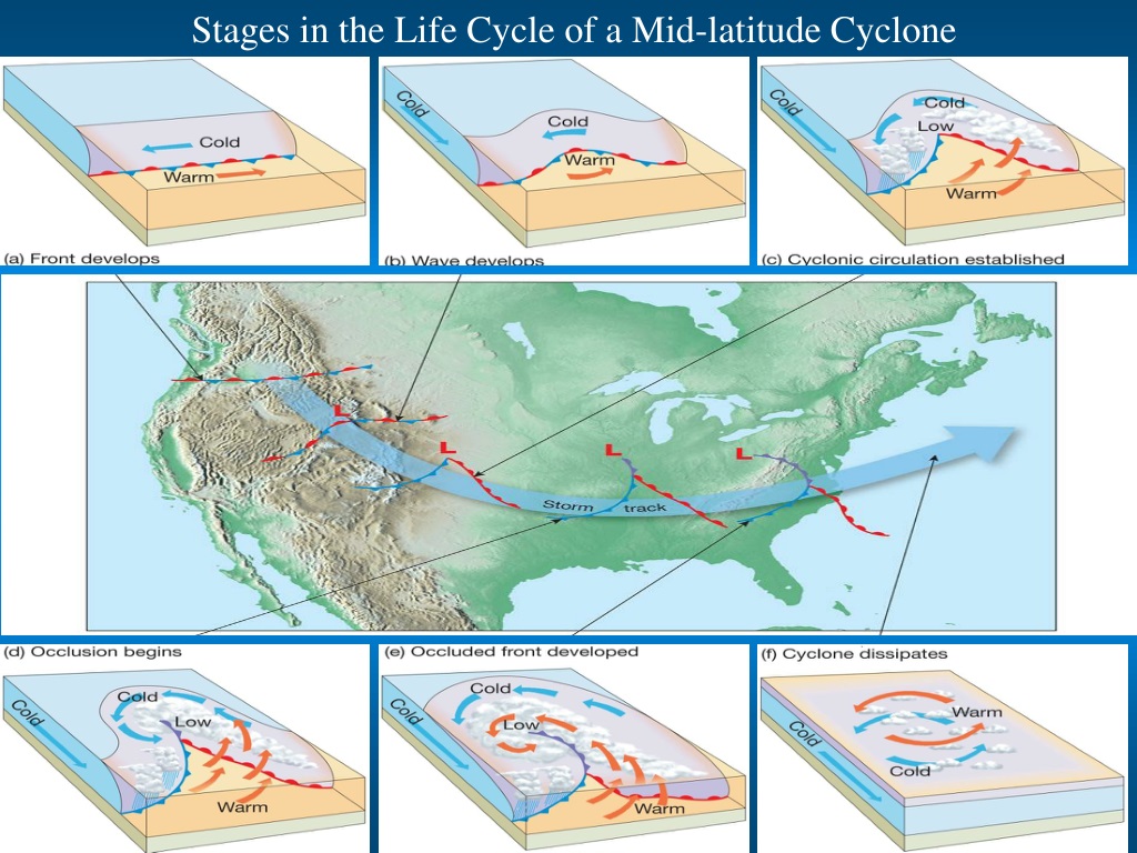
Here is a step-by-step breakdown corresponding to the diagram:
-
Stationary Front (a): The process begins with a stationary front, typically a segment of the polar front, which separates cold, dense polar air from warmer, lighter subtropical air. The winds on either side of the front blow parallel to it but in opposite directions.
-
Wave Development (b): A disturbance, often an upper-level wave in the jet stream, causes a "kink" or wave to form on the front. Air begins to rise, creating a localized area of low pressure.
-
Cyclonic Circulation (c): As the low pressure deepens, air begins to circulate in a counter-clockwise direction (in the Northern Hemisphere) around the low. This circulation pushes the cold air south-westward, creating a cold front, and the warm air north-eastward, creating a warm front. The area of warm air between the two fronts is called the warm sector. This is the weather experience you studied in the previous lesson.
-
Occlusion Begins (d): Cold fronts typically move faster than warm fronts. As the system matures, the cold front begins to catch up to the warm front, starting to lift the warm sector off the ground.
-
Occluded Front Developed (e): The cold front overtakes the warm front, forming an occluded front. The warm air of the warm sector is now completely lifted from the surface. This is often the stage of maximum intensity, with widespread cloudiness and precipitation.
-
Dissipation (f): The cyclone is now cut off from its energy source—the warm, moist air from the warm sector. The temperature differences at the surface diminish, the low-pressure center fills, and the storm gradually dissipates.
To solidify your understanding of this process, let's read a detailed description that accompanies a similar diagram.
LAB 4: Mid-Latitude Cyclones, Weather Maps & Forecasting
Now let's read a textual description of cyclogenesis. This resource walks through the same stages we just saw visually, providing a clear written summary of the Norwegian model.
Please read the section under the heading 'cyclogenesis' (it is illustrated by Figure 4.5 in the text). Compare the description of each stage to the 6-part diagram we just discussed.
3. A Deeper Look: The Role of the Upper Atmosphere
The Norwegian model provides an excellent description of what happens at the surface. But to understand why a cyclone forms and intensifies, we need to look higher up in the atmosphere. This aligns with your goal of developing a deeper, systematic understanding beyond simple descriptions.
The key lies in the interaction between the surface and the jet stream.
Extra-Tropical (Temperate) cyclones - Characteristics with Animation | UPSC (CSE) | Geography
The surface model doesn't fully explain what powers the cyclone's development. This animated video provides a more advanced, three-dimensional look, showing how disturbances in the jet stream are crucial for creating and intensifying the low-pressure system at the surface.
Watch from 1:07 to 4:06. Focus on two key ideas: How the wavelike flow of the jet stream creates a disturbance. The concept of 'upper air divergence'—air spreading out high up—which essentially vacuums air up from the surface, creating and strengthening the low-pressure center.
As the video showed, for a surface low-pressure system to deepen, air must be removed from the top of the air column faster than it is flowing in at the bottom. This removal of air aloft is called divergence. Without this upper-level divergence, the air converging at the surface would just "pile up," causing the pressure to rise and the cyclone to die.
This three-dimensional structure is the real engine of the storm.
12.2: Mid-latitude Frontal Cyclones
Let's solidify this advanced concept with a textual explanation. This resource explains the critical relationship between the surface low and the winds aloft.
Read the section titled 'Mid-latitude Cyclone in Three Dimensions'. The main takeaway is that for a surface low to get stronger, there must be divergence (an 'exit path') in the upper-level winds. This is why the storm's structure tilts westward with height.
Test your understanding!
Imagine a developing mid-latitude cyclone. If the upper-level winds suddenly changed so that there was convergence (air piling up) directly above the surface low-pressure center, what would happen to the cyclone? Why?
Show answer
The cyclone would weaken and dissipate very quickly. The convergence of air aloft would add mass to the air column, causing the surface pressure to rise. This would "fill in" the low-pressure center, eliminating the pressure gradients that drive the winds and the entire storm system. The storm needs upper-level divergence to survive and intensify.
4. Visual Signatures: The Comma Cloud
Now that we understand the life cycle and dynamics, let's see what these systems look like on real weather maps and satellite images. A mature mid-latitude cyclone has a very distinctive cloud pattern that resembles a comma.
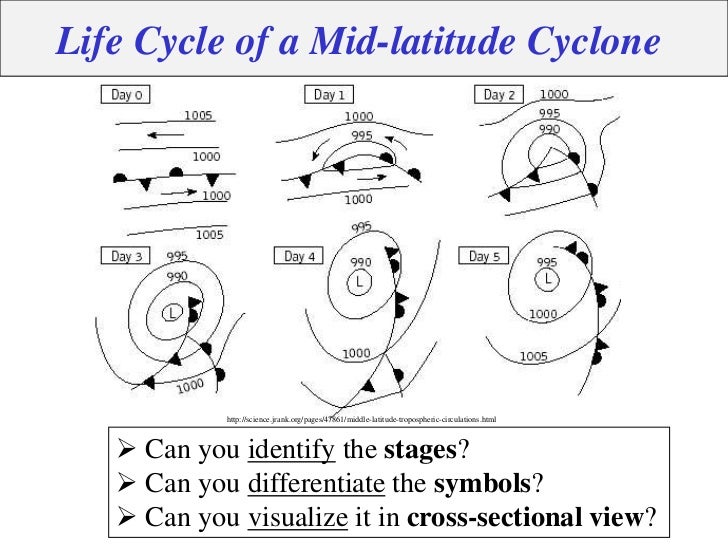
The map sequence above shows the frontal progression clearly. Now let's connect this to what we'd see from space.
Meteorology 15 - Mid-latitude Cyclones
Let's return to our first video to see this system on actual weather maps and satellite images. You'll see the classic 'comma' shape that is a signature of a mature mid-latitude cyclone.
Watch from 3:17 to 4:20. Notice how the sequence of fronts on the weather maps corresponds to the life cycle stages we discussed. Then, observe how this frontal structure creates the distinct comma-shaped cloud pattern in the satellite view.
The head of the comma is the area of widespread clouds around the low-pressure center, while the tail of the comma is the narrow band of clouds associated with the cold front.
Conclusion
Today, we have assembled a complete picture of the mid-latitude cyclone, the most important weather system in our latitudes. We traced its journey from a subtle wave on the polar front to a powerful, swirling storm, and finally to its quiet dissipation.
Key Takeaways:
- Mid-latitude cyclones are large, mobile low-pressure systems that form along the polar front and move from west to east.
- Their life cycle (cyclogenesis) follows the Norwegian Model: a stationary front develops a wave, which matures into a cyclone with warm and cold fronts, then occludes, and finally dissipates.
- Occlusion is a key process where the faster cold front overtakes the warm front, lifting the warm air (the storm's energy source) off the surface.
- The intensification of a cyclone depends critically on divergence (air spreading apart) in the upper atmosphere, often linked to the jet stream. This provides an "exit" for the air rising from the surface low.
- On satellite images, a mature mid-latitude cyclone has a characteristic comma shape.
Preview of the Next Module:
In our last few lessons, we've focused on specific weather phenomena like fronts and cyclones. These systems are the building blocks of a region's day-to-day weather. In our next module, we will zoom out even further to see how these patterns, when averaged over long periods, create the world's distinct climates. We will start by learning about the most widely used climate classification system, the Köppen climate classification, which will allow us to connect the dynamic weather systems we've studied to the broader patterns of global climate zones.