Introduction
Welcome to our next lesson on the forces that shape our planet's surface. In the previous session, we saw how rivers carve V-shaped valleys and build vast deltas. We will now turn our attention from liquid water to solid ice, exploring the immense power of glaciers.
Glaciers, often called "rivers of ice," are responsible for some of the most dramatic and distinctive landscapes on Earth. In this lesson, we will focus on identifying the major erosional and depositional landforms they create. Understanding features like cirques and moraines is not only fascinating but also essential for the physical geography portion of your SSC CGL exam.
How Glaciers Shape the Land
Before we look at the specific landforms, it's important to understand the fundamental ways glaciers work. A glacier is a huge mass of ice that moves slowly over land. As it moves, it erodes, transports, and deposits rock and sediment, acting like a giant conveyor belt and bulldozer combined.
The two primary methods of glacial erosion are:
- Plucking: As the glacier moves, it freezes onto rocks and sediment on the valley floor and sides. When the ice moves forward, it pulls these chunks of rock away.
- Abrasion: The rocks embedded in the base and sides of the glacier act like sandpaper, grinding against the bedrock below. This process smooths and scratches the underlying rock, leaving marks called striations.
Another process, freeze-thaw weathering, is common in glacial environments. Water seeps into cracks in rocks, freezes and expands (by about 9%), widening the crack. Repeated cycles of freezing and thawing cause the rock to shatter. This broken rock can then be easily picked up by the glacier.
The following short video provides a clear, animated explanation of these key processes.
Glacial Processes & Glacial Landforms | GCSE GEOGRAPHY
This video, from the "No Waffle GCSE" channel, gives a concise and clear explanation of the fundamental glacial processes.
Watch the segment from the beginning until the end of the section. Focus on understanding the definitions of abrasion, plucking, and freeze-thaw weathering. These are the tools a glacier uses to sculpt the land.
Erosional Landforms: Carving the Mountains
Glacial erosion creates spectacular and rugged mountain scenery. These features are most prominent in high-altitude regions that were once, or still are, covered by ice.
This diagram shows how several of these key erosional landforms relate to each other in a glaciated mountain landscape.
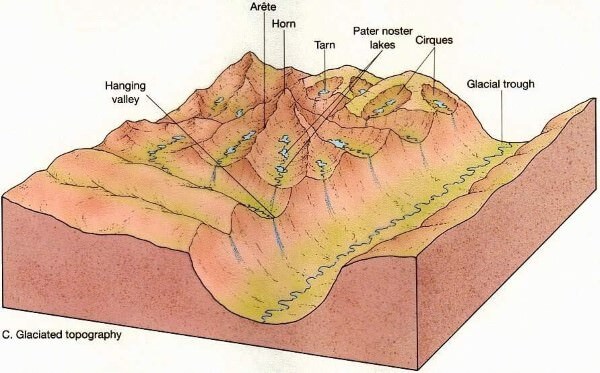
Now, let's define these key terms. The most important erosional landforms for your exam are:
- Cirque (or Corrie): An armchair-shaped hollow with a steep back wall, found at the head of a glacial valley. This is where a glacier begins to form. When the glacier melts, the cirque may fill with water to form a small lake called a tarn.
- Arête: A sharp, knife-like ridge formed when two cirques erode back-to-back or side-by-side.
- Horn: A sharp, pyramid-like peak that forms when three or more cirques erode a mountain from multiple sides. The Matterhorn in the Alps is a famous example.
- U-Shaped Valley (or Glacial Trough): In our last lesson, we saw that rivers carve V-shaped valleys. When a glacier flows down a pre-existing river valley, its immense weight and power erode the floor and sides, widening and deepening it into a characteristic U-shape.
- Hanging Valley: A smaller, shallower tributary valley that joins a main, deeper U-shaped valley. It "hangs" above the main valley floor because the smaller tributary glacier could not erode as deeply as the main glacier. Waterfalls are often found where hanging valleys meet the main trough.
To solidify these concepts, let's turn to an article specifically designed for competitive exams.
Cirque/ Corrie, Glacial Trough, Hanging Valley, Arete, Horn, Fjord
This article from Prepp provides concise, exam-focused definitions in a question-and-answer format, which is perfect for quick revision.
Please read the entire "FAQs" section. It gives clear, direct answers defining a cirque, glacial trough, hanging valley, and an arete.
Depositional Landforms: Leaving Debris Behind
As a glacier melts and retreats, it loses its power to carry sediment and drops everything it has been transporting. This unsorted mixture of clay, sand, gravel, and boulders is called glacial till. The landforms created by this deposition are just as distinct as the erosional ones.
The diagram below shows a glacier system and illustrates where different types of depositional features, especially moraines, are formed.

Let's define the most common depositional landforms:
- Moraines: These are ridges or mounds of glacial till deposited by a glacier. They are classified by their position:
- Lateral Moraine: Forms along the sides of a glacier.
- Medial Moraine: A ridge of moraine running down the center of a valley, formed when two glaciers merge and their lateral moraines combine.
- Terminal Moraine: A ridge of till deposited at the glacier's snout (its front end), marking the furthest point the glacier reached.
- Drumlins: Elongated, oval-shaped hills made of till. The steep side faces the direction from which the ice came, while the other side is a gentle slope. A landscape of many drumlins is often called a "basket of eggs topography."
- Eskers: Long, winding ridges of sand and gravel. These were formed by meltwater streams flowing in tunnels beneath the glacier. When the ice melted, the sediment from the stream bed was left behind as a ridge.
- Outwash Plain: A flat, expansive plain formed by meltwater streams transporting sediment away from the front of a glacier.
To get the precise definitions you'll need for your exam, we'll consult the companion article from Prepp.
Outwash Plain, Eskers, Kame Terraces, Drumlin, Kettle Holes, Moraine
This article details the key depositional features left behind by glaciers.
In the section "Glacial Depositional Landforms," read the definitions for Moraines, noting the different types (lateral, medial, terminal). Then, read the descriptions of Drumlins, Eskers, and Outwash plains.
For practice, you can try the multiple-choice questions (MCQs) at the end of both Prepp articles (Glacial Erosional Landforms and Glacial Depositional Landforms) to test your understanding of these key terms.
Conclusion
In this lesson, we have explored how glaciers, through powerful processes of erosion and deposition, create some of the world's most dramatic landscapes. You can now identify the key features that signal past or present glacial activity, a crucial skill for your geography preparation.
Key Takeaways:
- Glaciers erode through plucking (pulling away rock) and abrasion (grinding the bedrock).
- Major erosional landforms include cirques (armchair hollows), arêtes (sharp ridges), horns (pyramidal peaks), and U-shaped valleys.
- Major depositional landforms, made of glacial till, include moraines (ridges of debris), drumlins (elongated hills), and eskers (winding ridges from sub-glacial streams).
In our final lesson on landforms, we will shift from the cold, icy regions to hot, dry deserts. We will examine how wind acts as an agent of erosion and deposition, creating unique features like sand dunes and mushroom rocks.