Introduction
In our last lesson, we explored the powerful internal forces of the Earth, linking earthquakes and volcanoes to the movements at plate boundaries. We now shift our focus from the forces that build up the land (endogenic forces) to those that wear it down (exogenic forces).
This lesson begins our look at the agents of erosion and deposition that sculpt the Earth's surface. We will start with one of the most significant: rivers. By the end of this session, you will be able to identify the major erosional and depositional landforms created by rivers, such as V-shaped valleys and deltas. This knowledge is a cornerstone of physical geography and a frequent topic in the General Awareness section of the SSC CGL exam.
The Journey of a River
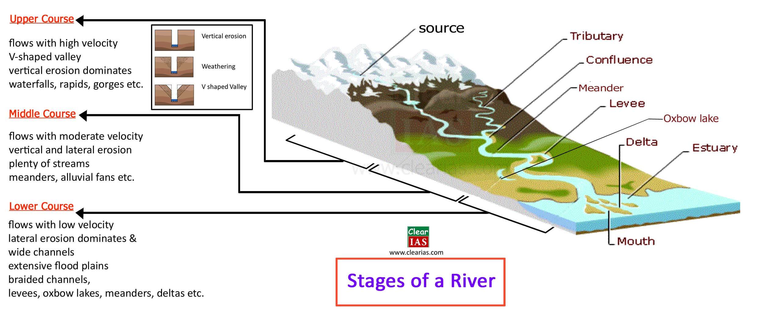
A river's journey from its source in the mountains to its mouth at the sea is a continuous process of shaping the landscape. Geographers typically divide this journey into three main stages: the Upper Course, Middle Course, and Lower Course. Each stage is characterized by different energy levels, dominant processes (erosion or deposition), and as a result, distinct landforms.
The image below provides an excellent overview of this entire process, which will serve as our guide for this lesson.
To get a quick overview of these stages and the types of features found in each, let's watch a short segment from a video designed for SSC CGL preparation.
LANDFORMS IN GEOGRAPHY FOR SSC CGL 2025| PARMAR SSC
This video from PARMAR SSC concisely explains the three stages of a river and the dominant geological work in each.
Watch the section from the beginning, where the instructor outlines the youthful, mature, and old stages. Focus on the key idea: the youthful stage is dominated by erosion due to high speed, while the mature and old stages are characterized by deposition.
As you saw, the river's energy is the primary driver. High in the mountains, steep slopes give the river high velocity and erosive power. As the river flows onto flatter plains, its energy decreases, causing it to deposit the sediment it has been carrying.
Erosional Landforms: Carving the Landscape
In its upper course, a river's main job is to cut downwards. This vertical erosion, combined with weathering of the valley sides, creates some of the most dramatic river features.
To understand the mechanics, let's first look at an article that defines the basic processes.
River Landforms, Formation, Processes, Types of Erosional ...
This article from Testbook provides clear, exam-oriented definitions. We'll start with the fundamental processes of river erosion.
Please read the section titled "What are the Processes Involved in the Formation of River Landforms?". Focus on understanding the four key terms: Corrosion/Abrasion (grinding), Corrosion/Solution (dissolving), Hydraulic action (force of water), and Attrition (sediments colliding with each other).
These processes are most powerful in the steep, fast-flowing upper course, leading to iconic erosional landforms.
- V-Shaped Valleys and Gorges: As a river rapidly erodes its bed downwards, a narrow and deep channel forms. Mass wasting and weathering on the valley sides create a distinct 'V' shape. When the rock is very resistant, the valley sides can be nearly vertical, forming a gorge.
- Waterfalls: These form when a river flows over a layer of hard, resistant rock onto a layer of softer, more easily eroded rock. The softer rock is worn away more quickly, creating a steep drop.
The following video offers excellent visual examples of these features.
Fluvial Landforms | Erosional and Depositional Features by River| Geomorphology | Dr. Krishnanand
The video "Fluvial Landforms" by TheGeoecologist has clear, real-world footage of these landforms.
Watch the following clips to see what these features actually look like: Gorges and Canyons: This segment shows the deep, steep-sided valleys carved by vertical erosion. V-Shaped Valley: Here, you can clearly see the characteristic V-shape. Waterfalls: Watch from this point to see a true waterfall, where water has a free fall. Notice how the presenter distinguishes it from a "cascade."
Depositional Landforms: Building New Land
As the river reaches its middle and lower courses, the gradient flattens, velocity drops, and it begins to deposit the sediment (alluvium) it carried from the mountains. This depositional work creates vast, fertile landscapes.
- Meanders and Oxbow Lakes: On gentle slopes, the river begins to flow in wide curves called meanders. Erosion happens on the outer bank of the curve (where water is faster), while deposition occurs on the inner bank (where water is slower). Over time, the meander loop becomes very pronounced until the river cuts a new, straighter channel during a flood, leaving behind a crescent-shaped lake called an oxbow lake.
- Floodplains and Levees: During floods, the river overflows its banks, depositing a layer of fine sediment over the adjacent flat land, creating a floodplain. As the water recedes, the coarsest material is dropped right at the river's edge, building up natural embankments called levees.
- Deltas: When a river reaches a standing body of water like a lake or the sea, it loses all its energy and drops its entire load of sediment. This deposited material builds up over time to form a triangular, fan-shaped landmass called a delta.
Let's read the definitions for these key features from the Testbook article.
River Landforms, Formation, Processes, Types of Erosional ...
This article clearly explains the formation of these depositional and mixed landforms.
First, read about the features formed by both erosion and deposition. Pay close attention to the descriptions of Meanders and Oxbow Lakes. Next, in the "Depositional Landforms" section, focus on the definitions of Flood Plains, Levees, and Deltas.
Indian Examples for Your Exam
For the SSC CGL and other competitive exams, it is crucial to know specific examples of these landforms in India. The Testbook article provides a handy table with this exact information.
River Landforms, Formation, Processes, Types of Erosional ...
This section gives you the specific, high-yield facts you need for your exam.
Study the table under the heading "Examples of River Landforms in India". Note the locations for the Ganga-Brahmaputra Delta (the world's largest), the potholes on the Narmada river, and the meandering courses of the Ganga.
Conclusion
Today we have traced the journey of a river and seen how it acts as a powerful architect of the landscape. You can now differentiate between the work of a river in its upper, middle, and lower courses and identify the key landforms that result.
Key Takeaways:
- Rivers shape the land through erosion (wearing away) and deposition (dropping sediment).
- The Upper Course (youthful stage) is dominated by vertical erosion, creating features like V-shaped valleys, gorges, and waterfalls.
- The Middle and Lower Courses (mature and old stages) are dominated by lateral erosion and deposition, forming meanders, oxbow lakes, floodplains, and deltas.
- Knowing Indian examples, such as the Sundarbans Delta, is essential for your exam preparation.
In our next lesson, we will continue exploring exogenic forces by examining another powerful agent of erosion and deposition: glaciers. We will see how massive ice sheets carve out unique landscapes like U-shaped valleys and leave behind distinct features like moraines.