Hello! Welcome back to your course on geopolitics.
In the last lesson, we explored the "grand theories" of classical geopolitics, focusing on Mahan's sea power doctrine, Mackinder's Heartland theory, and Spykman's Rimland theory. These frameworks help us understand the large-scale strategic motivations of states based on their macro-geographical position.
Today, we drill down from the grand theoretical map to the physical one. We will examine how specific features of the Earth's surface—narrow waterways, the location of valuable materials, and the shape of the land itself—directly influence state decisions. If the classical theories explain why states compete, today's lesson explains how geography shapes the moment-to-moment gameplay.
This directly connects to your reading of Tim Marshall's Prisoners of Geography, but we will add an analytical layer to it, applying these concepts to contemporary strategic challenges. The learning outcome for this lesson is to: Analyze how physical geography (chokepoints, resource distribution, terrain) constrains and enables state behavior, applying concepts to contemporary strategic issues.
1. Bottlenecks of Power: Maritime Chokepoints
In the previous lesson, we saw Mahan's emphasis on controlling the seas. Central to this control is the domination of maritime chokepoints: narrow channels of water that are critical to global trade and military movement.
Think of the global shipping network as a massive distributed system. Chokepoints are the critical nodes where traffic is concentrated, making them single points of failure. Disrupting a chokepoint can have cascading effects on the entire system, creating immense economic and military leverage.
The following video from DW News provides an excellent overview of this concept with very current examples.
Chokepoints: How small waterways make big powers vulnerable | Mapped Out
This video, 'Chokepoints: How small waterways make big powers vulnerable', explores why these narrow passages are so important and how they create vulnerabilities for major powers like the US, China, and Russia.
Please watch the following three segments: Introduction (00:00 - 02:45): This part uses the recent Houthi attacks in the Red Sea to explain the fundamental concept of a chokepoint and its disruptive power. The Malacca Dilemma (02:45 - 04:58): Focus on why the Strait of Malacca is a critical vulnerability for China. Strategies for Chokepoints (10:31 - 13:02): This segment contrasts the different strategies major powers use to manage their chokepoint vulnerabilities: projecting power, building alternatives, or using stealth.
To visualize the global layout of these critical passages, take a look at this map.

As the video highlighted, the fear of a chokepoint being closed off can drive a nation's grand strategy.
- China's "Malacca Dilemma" is a prime example. The fact that over 80% of its oil imports pass through the Strait of Malacca—a strait largely policed by the US Navy and its allies—is a massive strategic vulnerability. This single geographical constraint is a major driver behind China's Belt and Road Initiative (BRI), which seeks to create alternative overland routes for energy and trade, such as the China-Pakistan Economic Corridor (CPEC).
- Iran's Asymmetric Strategy: The Strait of Hormuz, through which about 20% of the world's oil passes, provides Iran with immense leverage. Lacking a navy that can compete with the US in open water, Iran has developed a strategy of asymmetric warfare tailored specifically to this chokepoint, using fast-attack craft, mines, and anti-ship missiles to threaten its closure.
For a concise academic explanation of Iran's strategy, which is dictated almost entirely by the geography of the Persian Gulf and the Strait of Hormuz, please read the following case study.
[PDF] Geopolitics: An Overview of Concepts and Empirical ...
This excerpt from the paper 'Geopolitics: An Overview of Concepts and Empirical...' provides a clear case study on how the geography of a chokepoint shapes a nation's entire military doctrine.
Please read the section titled 'Iran’s strategy of asymmetric maritime warfare' (begins on page 18). Focus on the three geographical aspects that define Iran's maritime strategy.
2. The Lottery of Location: Resource Distribution
Geography doesn't just constrain movement; it also dictates the location of essential resources. The uneven distribution of energy (oil, gas) and minerals is a fundamental driver of international politics.
In the 21st century, this dynamic is most acute in the realm of critical minerals. Your background in computer engineering gives you a unique appreciation for this: the technologies defining our era—semiconductors, AI data centers, high-capacity batteries, and advanced weaponry—are all dependent on a small group of elements, often called rare earths. The countries that control the mining and, more importantly, the processing of these minerals hold a powerful new form of geopolitical leverage.
The following discussion from the Council on Foreign Relations explores this new geopolitical arena.
The Geopolitics of Critical Minerals—Risks, Resilience, and Resource Control
This panel, 'The Geopolitics of Critical Minerals', features experts discussing how the supply chain for these materials has become a central front in great power competition, especially between the US and China.
Please watch these three clips: Geology is Geopolitical (02:38 - 05:09): This introduces the core idea that China has established a strategic 'chokehold' not just on mining, but on the entire refining and processing supply chain. How We Got Here (05:09 - 09:03): This explains the historical context of how China strategically invested in these supply chains while the West focused elsewhere. Weaponization in Action (01:01:22 - 01:05:59): This segment discusses the real-world impact of China using its dominance as leverage by implementing export restrictions on minerals like gallium and germanium, which are vital for high-end electronics.
The key takeaway is that geopolitical chokepoints are not always physical straits. In the context of modern technology, a chokepoint can be a single country that dominates a critical step in a global supply chain. China's control over rare earth processing is a strategic vulnerability for the West, analogous to the Malacca Dilemma for China. This understanding is central to the ongoing "chip war" and the race to build resilient technological supply chains, topics we will explore in detail later in the course.
3. Mountains and Plains: The Influence of Terrain
Finally, the very texture of the land—its mountains, plains, rivers, and deserts—powerfully shapes a state's security, economic life, and even its political identity.
- Barriers: Mountain ranges like the Himalayas, vast deserts like the Sahara, or dense jungles like the Amazon act as natural barriers. They impede trade, slow down invading armies, and can cause cultural and political fragmentation within a state.
- Corridors: Conversely, flat, open areas like the North European Plain or major river valleys like the Ganges have historically been corridors for trade, migration, and invasion. States in these regions are often easy to traverse but difficult to defend.
Given your background and interests, Nepal serves as a perfect case study of how terrain defines a nation's strategic posture.
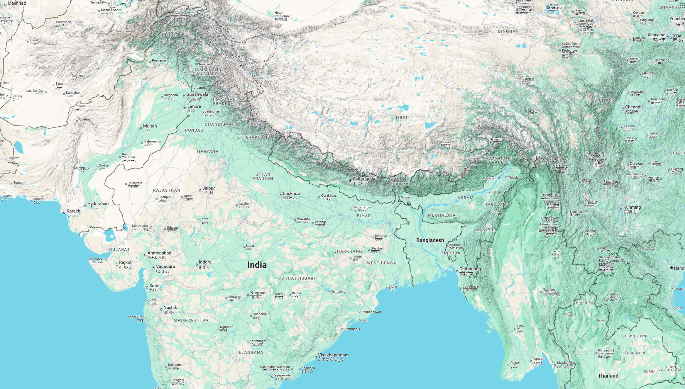
This unique geographical position—landlocked and sandwiched between two giants in one of the world's most formidable mountain ranges—is the single most important factor in Nepal's foreign policy. It creates both constraints and opportunities.
Regional Rivalries and Extra-regional Interests in Nepal | GJIA
The article 'Managing Regional Rivalries and Extraregional Interests as a Buffer State: The Nepalese Case Study' by Bibek Chand offers an excellent analysis of how Nepal navigates its geographical predicament.
Please read the introduction of the article. It concisely defines Nepal as a 'buffer state' and explains how its 'challenging geography' dictates its foreign policy strategy.
As the article argues, Nepal's terrain makes it a natural buffer state. This is a profound constraint, forcing it to constantly manage the security concerns of both India and China. However, this geography also enables a specific strategy. Because it cannot hope to militarily match its neighbors, Nepal is incentivized to pursue a sophisticated foreign policy of "equidistance," multilateralism, and engagement with extra-regional powers (like the US and EU) to maintain its strategic autonomy. Its geography forces it to be a skilled diplomat.
Conclusion
Today we've seen how the physical world directly shapes state strategy. The abstract board of Mackinder and Spykman is, in reality, a textured landscape of mountains, straits, and resource deposits.
Key Takeaways:
- Maritime Chokepoints are narrow waterways that concentrate global trade, creating critical vulnerabilities that states seek to control, secure, or bypass.
- Resource Distribution, particularly of energy and the critical minerals needed for modern technology, creates dependencies that become powerful tools of geopolitical leverage.
- Terrain acts as a system of barriers and corridors that constrains a state's military options, shapes its economic potential, and defines its fundamental strategic challenges and opportunities, as exemplified by Nepal's position as a buffer state.
These geographical factors are not entirely deterministic—as we've seen, technology and diplomacy can mitigate them—but they represent the persistent, structural realities that every national leader must confront.
In our next lesson, we will shift our focus from the physical map to the political one. We will explore the foundational concepts of the modern international system: the nation-state, sovereignty, and the Westphalian system. This will help us understand the legal and normative framework within which all this geographical competition takes place.