Hello! Let's dive into our next lesson on China's grand strategy.
In our previous lesson, we examined the Belt and Road Initiative (BRI) as China's primary tool for reshaping its external environment. We saw how it aims to solve the "Malacca Dilemma" and project power through a "String of Pearls," driven by deep-seated economic and geostrategic objectives.
Today, we'll zoom in on one of the world's most tense and strategically significant maritime regions, where China's ambitions are on a direct collision course with international law and its neighbors. This lesson directly addresses a key part of China's strategy and your interest in how great power competition destabilizes regions.
Our learning outcome is to: Analyze China's strategy in the South China Sea, focusing on its historical claims, island-building, and challenges to international law.
We will cover:
- The immense strategic and economic importance of the South China Sea.
- China's controversial "nine-dash line" and its historical basis (or lack thereof).
- The clash between China's claims and the United Nations Convention on the Law of the Sea (UNCLOS).
- China's campaign of artificial island-building and militarization.
- The "grey-zone" tactics China uses to assert control without triggering open war.
1. The World's Most Important Waterway
Why does a body of water south of China command so much global attention? The South China Sea is not just any ocean; it is a critical artery of the global economy and a reservoir of resources. Control over this sea means control over immense wealth and strategic leverage.
Why China is building islands in the South China Sea
To start, let's get a clear picture of what's at stake. This video from Vox effectively summarizes why the South China Sea is so important.
Watch the short clip from 01:16 to 01:44. Focus on the three main reasons for the sea's importance: natural resources, fisheries, and shipping trade.
As the video highlights, the South China Sea is vital for several reasons:
- Trade: An estimated one-third of global shipping, worth over $3 trillion annually, passes through its sea lanes. This directly connects to the "Malacca Dilemma" we discussed; these are the very sea lanes China feels dangerously dependent on.
- Energy: It is believed to hold significant reserves of oil (around 11 billion barrels) and natural gas (190 trillion cubic feet).
- Food Security: It accounts for approximately 12% of the world's entire fish catch, crucial for the food security of millions in the surrounding coastal nations.
Given your background in system optimization, you can think of the South China Sea as a network hub with massive bandwidth for global trade. Any single actor seeking to control that hub gains immense leverage over the entire network's traffic.
2. The "Nine-Dash Line" vs. International Law
At the heart of the dispute is the profound conflict between China's claims and the established international legal order for the oceans.
China's "Historic" Claim
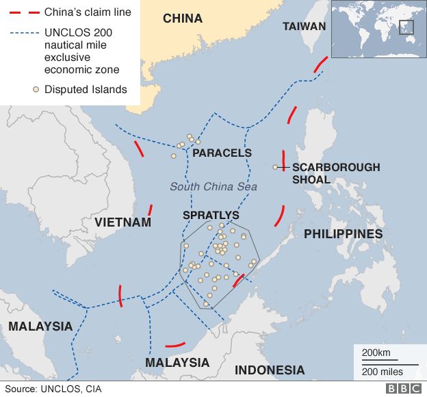
China's claim is famously demarcated by the "nine-dash line," an ambiguous U-shaped line that encompasses up to 90% of the South China Sea. Beijing argues this claim is based on "historic rights," suggesting Chinese sailors discovered and named these islands centuries ago.
However, historical analysis shows this narrative to be a modern political construction.
The South China Sea: Historical and legal background
To deconstruct China's historical narrative, let's turn to a detailed analysis that traces the actual origin of the 'nine-dash line'. This paper from Geostrategy, a British think tank, provides a concise but thorough debunking.
Please read the following sections: The introduction. 'The emergence of Chinese claims in the South China Sea'. 'The origin of the ‘U-shaped’ or ‘nine-dash’ line'. 'Standard propaganda lines'. Focus on how the article argues that the claims are a modern invention based on misinterpretations, mistranslations, and the work of private map-makers in the 1930s and 40s, rather than ancient history.
As the article makes clear, the nine-dash line is not an ancient boundary but a 20th-century invention that was "reverse engineered" to justify a territorial claim.
The International Law: UNCLOS
The globally accepted framework for maritime law is the 1982 United Nations Convention on the Law of the Sea (UNCLOS), which China has ratified. UNCLOS establishes clear rules for maritime zones.
Tensions Escalate in The South China Sea: Why China Build Islands to Claim The Sea - TLDR News
To understand precisely why China's claims clash with modern maritime law, we need to understand the key concepts of UNCLOS. This video from TLDR News offers a very clear explanation.
Watch the segment from 05:27 to 07:55. Pay close attention to the definitions of: Territorial Sea (12 nautical miles) Exclusive Economic Zone (EEZ) (200 nautical miles) The crucial difference between an 'island,' a 'rock,' and a 'low-tide elevation,' and the different rights each type of feature generates.
Here is the fundamental conflict:
- UNCLOS grants a coastal state an Exclusive Economic Zone (EEZ) of 200 nautical miles from its shore, giving it sovereign rights to the resources within that zone.
- China's nine-dash line cuts deep into the EEZs of Vietnam, the Philippines, Malaysia, Indonesia, and Brunei.
- Furthermore, UNCLOS states that only naturally formed islands that can sustain human habitation or economic life can generate their own EEZ. Rocks and reefs cannot. China's claims, however, treat these features as if they were full-fledged islands.
3. Strategy in Action: Creating "Facts on the Water"
Unable to win the legal argument, China has pursued a strategy of creating "facts on the water"—or more accurately, "facts out of the water." Since 2013, China has undertaken a massive and unprecedented campaign of land reclamation.
Why China is building islands in the South China Sea
Let's see how China is translating its claims into physical reality. The Vox video we started with has a powerful visual account of this island-building campaign.
Watch the first minute and sixteen seconds of the video (00:00 - 01:16). Focus on the scale and speed of the construction and, most importantly, the military nature of the infrastructure being built (airstrips, radar, missile systems).
China has used fleets of dredgers to pump sand onto submerged reefs in the Spratly Islands, turning them into large artificial islands. These islands have since been equipped with:
- Long runways capable of handling military transport planes and fighter jets.
- Hardened aircraft hangars.
- Advanced radar arrays and communications equipment.
- Anti-aircraft and anti-ship missile systems.

The purpose is threefold:
- Strengthen its legal claim (unsuccessfully): By creating "islands," China hoped to generate maritime zones under UNCLOS. However, the law is clear that artificial islands do not generate their own territorial sea or EEZ.
- Establish physical control: These bases allow China's coast guard and navy to maintain a persistent presence, monitor foreign vessels, and project power across the entire region.
- Create a strategic bastion: As noted in the Geostrategy article, a key motivation is likely to turn the South China Sea into a protected "bastion" for its fleet of nuclear-powered ballistic missile submarines (SSBNs). These submarines are China's ultimate nuclear deterrent, and a secure area to hide them is a paramount strategic interest.
4. The "Cabbage Strategy": Winning Without Fighting
China's brilliance lies in how it asserts control using "grey-zone" tactics—actions that are coercive and aggressive but fall just below the threshold of an act of war. The most famous of these is the "Cabbage Strategy."
The South China Sea: Historical and legal background
The 'cabbage strategy' is a core component of China's operational approach. The Geostrategy paper you read earlier provides an excellent description of how this multi-layered tactic works.
Please reread the subsection titled 'The CCP’s motivations' (found under 'The present day'). Focus specifically on the final paragraph that describes the 'grey zone' operations and the 'cabbage leaf' tactics involving the Maritime Militia, China Coast Guard, and the PLAN.
The strategy involves swarming a contested feature with concentric layers of vessels:
- Inner Layer: The Maritime Militia, a force of supposedly civilian fishing boats, which are professionally trained and equipped for state missions. Their civilian status creates confusion and complicates a military response from other nations.
- Middle Layer: The China Coast Guard (CCG), with large, heavily-armed cutters that can intimidate and physically block ships from other countries using ramming or powerful water cannons.
- Outer Layer: The People's Liberation Army Navy (PLAN), which waits over the horizon, ready to intervene if the situation escalates.
This tactic effectively isolates a target (like a Philippine-held reef) from resupply, gradually squeezing it into submission, leaf by leaf, like a cabbage.
5. International Response and the Legal Rebuke
China's actions have not gone unchallenged. In 2013, the Philippines initiated an arbitration case against China under UNCLOS.
In July 2016, the Arbitral Tribunal at The Hague delivered a landmark ruling:
- It declared that there was no legal basis for China's "historic rights" claim within the nine-dash line.
- It ruled that none of the features in the Spratly Islands are "islands" capable of generating a 200-mile EEZ.
- It found that China's actions, including its island-building and interference with Filipino fishermen, had violated the Philippines' sovereign rights.
China's response was to declare the ruling "null and void" and refuse to participate or recognize its legitimacy.
The United States, while not a claimant, asserts its rights under international law by conducting Freedom of Navigation Operations (FONOPs), where US Navy warships deliberately sail within 12 nautical miles of China's artificial islands to challenge their illegitimate claims to a territorial sea.
Conclusion
China's strategy in the South China Sea is a masterful, multi-faceted application of legal, psychological, and physical power to achieve strategic objectives while managing escalation. It is a textbook case of a rising power attempting to revise the established order in its favor.
Key Takeaways:
- Strategic & Economic Hub: The South China Sea is a critical global chokepoint for trade and rich in natural resources, making its control a major strategic prize.
- Lawfare: China employs "lawfare" by promoting its "historic rights" via the nine-dash line, a claim that directly contradicts and challenges the internationally recognized UN Convention on the Law of the Sea (UNCLOS).
- Creating Facts: Through a massive island-building campaign, China has constructed a network of militarized bases to enforce its claims, project power, and potentially create a strategic bastion for its nuclear submarine fleet.
- Grey-Zone Coercion: China uses its Coast Guard and Maritime Militia in "cabbage strategy" tactics to assert control and intimidate rivals without triggering a formal war.
- Defiance of International Law: Despite a comprehensive 2016 international tribunal ruling that invalidated its claims, China continues to defy the verdict, creating a persistent challenge to the "rules-based international order."
Preview of the Next Lesson:
Having explored the BRI and the South China Sea, we've seen how China is pursuing its grand strategy externally. Next, we will turn to a topic that is highly relevant to your background: Analyze the geopolitical dynamics of the Taiwan Strait, including the 'One China' policy, US strategic ambiguity, and the military balance. This is another critical flashpoint where technology, history, and great power competition intersect.