Hello. Last lesson established that a grizzly is a brown bear, and that differences in food access help explain some regional differences in size and diet. Now the question shifts from what kind of bear is it? to what does a bear need from a place? You will assess a landscape by looking for food at different times of year, places to rest and den, and routes between useful areas. That is more informative than judging habitat by how wild or forested it looks.
A home range is a collection of seasonal opportunities
A grizzly does not need every resource in one spot. It needs access to a home range large enough to meet its needs over time. A valley bottom might offer spring feeding, while berries become available later in higher meadows. The bear must be able to travel between them. Home ranges vary with food availability and the bear’s circumstances; they are not fixed-size territories defended against every other bear.
The National Park Service gives a compact landscape example:
Grizzly Bears - North Cascades National Park (U.S. National Park Service)
Read the National Park Service’s “Grizzly Bears” profile to see how several habitat features fit together within a home range.
Under the “Grizzly Bear” profile, find the paragraph beginning “Grizzly bears do not defend a territory.” Read the home-range example through its final sentence about avalanche chutes. Focus on why valley bottoms, high meadows, denning slopes, and avalanche chutes are useful at different times or for different purposes. Treat the home-range figures as examples, not a required area for every bear.
The crucial word is access. A landscape may contain abundant berries, yet offer poor habitat if bears cannot reach them safely from the places they use earlier in the year. Conversely, a single photograph of sparse-looking terrain cannot establish that a wider home range lacks food.
Food availability changes not just by location but by date. This short video segment shows why a map of vegetation alone is less useful than a map that also tracks when plants become nutritious.
Tracking grizzly bears from space - David Laskin
Watch TED-Ed’s “Tracking grizzly bears from space,” presented by David Laskin, for an illustration of seasonal feeding and how researchers map it.
Watch seasonal foraging for the link between plant growth and bear movements. Then watch mapping methods for how satellite observations of vegetation can be compared with GPS locations from bears. The plant-heavy diet described here concerns the population in the video; it is not a fixed diet for all grizzlies.
For this lesson, the dietary point is simple: suitable habitat supplies enough obtainable food across the active season, not merely a promising food source on one summer day. The next lesson will examine seasonal diets in more detail.
Food is not enough: cover, security, and dens
Bears also need places to rest and avoid disturbance. Cover can be vegetation that provides shade and concealment; it need not be continuous forest. A mixture of feeding openings and nearby cover may be more useful than either alone. Security adds another dimension: a food-rich area used heavily by people may be available on a map but difficult or risky for a bear to use.
A denning site serves a different purpose from a day bed. In many mountain settings, bears dig dens on steep slopes where deep, persistent snow helps insulate them. Suitable sites vary by region, however; natural cavities can also provide dens. A north-facing slope is a useful clue in some landscapes, not a universal rule or a substitute for checking local conditions.
Grizzly Bear (Ursus arctos horribilis) | U.S. Fish & Wildlife Service
The U.S. Fish & Wildlife Service species profile separates habitat productivity from the security and den sites that make resources usable.
In the profile’s “Habitat” discussion, read habitat needs, beginning with food and movement and ending with the definition of habitat components. Continue to cover and beds, from the paragraph on resting cover through its final sentence on shade and sleeping. Then read habitat security, ending at the sentence about managing motorized access. Finally, find the denning passage beginning “Grizzly bears typically hibernate alone in dens” and read denning conditions to the end of that passage. Notice that the listed elevations and slope directions describe particular ecosystems, rather than universal cutoffs for suitability.
This yields a practical distinction. Habitat productivity concerns the amount, quality, and distribution of resources such as food. Habitat security concerns whether bears can use those resources without excessive disturbance or risk. Neither automatically follows from the other. A meadow beside a busy road may produce excellent forage but provide poor secure access; an undisturbed slope may offer excellent cover but little food.
Water belongs in the assessment too, especially where it might be scarce. The Fish & Wildlife Service notes that water does not appear to limit bears in the habitat they currently occupy, while acknowledging that this may not hold everywhere. Avoid turning a useful local observation into a rule for every landscape.
Connections matter at two scales
Within a home range, connections let a bear reach seasonal resources: spring feeding areas, later foods, cover, and denning terrain. Across a wider region, connections allow movement between areas that support different bear populations. A patch can therefore be good feeding habitat yet contribute less to long-term population suitability if roads or development make movement to and from it hazardous.
The Fish & Wildlife Service makes the larger-scale point in its discussion of recovery areas:
Grizzly Bear (Ursus arctos horribilis) | U.S. Fish & Wildlife Service
Return to the Fish & Wildlife Service profile for the distinction between a sufficiently large habitat area and connections among such areas.
Find the passage beginning “The 1993 U.S. Fish and Wildlife Service Recovery Plan identified six ecosystems.” Read recovery connections through the sentence on isolated populations. Focus on why suitable habitat outside a designated core area, and the ability to move between areas, can both matter.
The following video shows what a connection problem can look like on the ground. It depicts one region, rather than proving that every road affects every bear in the same way.
We’re creating the world’s biggest wildlife corridor
Watch Planet Wild’s “We’re creating the world’s biggest wildlife corridor” for a concrete example of transport routes separating bear habitat.
Watch fragmentation for the road and railway obstacles described in one valley. Then skip to population connection for the example of a road dividing grizzly groups. Attend to the distinction between habitat existing on both sides and bears being able to cross between them safely.
A corridor is not suitable simply because a line can be drawn through undeveloped land. The route must offer a plausible way for bears to move, with risks and barriers considered along its length. Equally, a road does not prove that no bears ever cross. The assessment asks how reliably and safely the landscape functions, not whether movement is theoretically possible.
This research graphic brings together predicted habitat use and connectivity across several Northern Rockies areas:
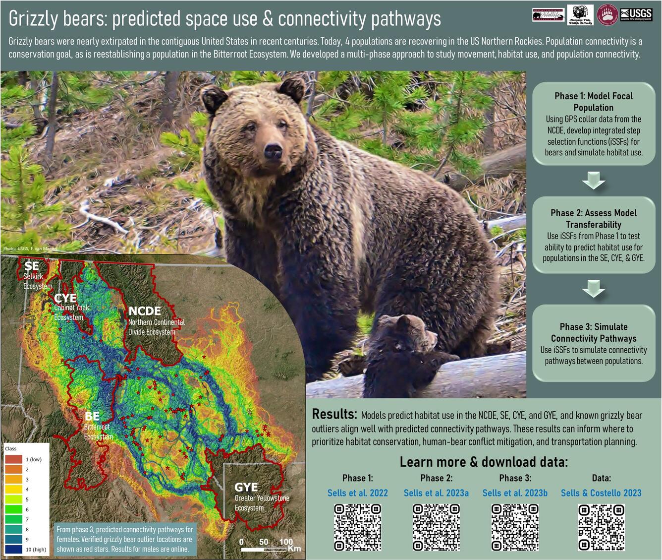
The graphic’s distinction between predicted pathways and verified locations matters. Models can identify places worth investigating or protecting, but a colored band on a map does not establish that bears can move through it without encountering a dangerous crossing or other obstacle. Later, you will look more closely at what tracking observations can—and cannot—tell researchers.
Putting the assessment together
Imagine two connected mountain valleys with spring vegetation, summer berries, wooded resting areas, and steep slopes that retain snow. On resource availability alone, they look promising. Now add a busy road between the valleys and frequent motorized access near the principal feeding areas. The assessment changes: seasonal foods and potential dens remain strengths, but secure use and movement are uncertain or compromised.
A sound judgment names both strengths and limits. For a landscape you have not surveyed directly, use four checks:
- Food through time: Are useful foods available in enough places during the active season, and can bears reach them as conditions change?
- Cover and security: Are there places to rest near feeding areas, and does human activity restrict safe access?
- Denning opportunities: Are there locally suitable, relatively secure places to den—not merely slopes that match a description from another region?
- Connections: Can bears move among seasonal resources and, where relevant, between wider habitat areas without substantial barriers or risks?
These checks produce a reasoned assessment, not a guarantee that bears will occupy a site. Food supplies fluctuate, individuals use landscapes differently, and maps may leave out important disturbances. Where evidence is missing, “potentially suitable, but connectivity needs checking” is stronger reasoning than an unjustified yes or no.
Takeaway
Grizzly habitat is a usable seasonal landscape, not a single habitat type. Food, cover, secure resting areas, denning opportunities, and connections must work together across space and time. A resource-rich patch can lose much of its value when disturbance or hazardous crossings prevent bears from using it.
Next, you will take the food part of this assessment further: constructing a seasonal diet from what a particular habitat offers, including the intensified feeding before winter denning.