Hello! Welcome to the next lesson in our journey to build a strong foundation in physical geography.
In our last lesson, we focused on longitude and its crucial connection to time, exploring how we calculate time differences and organize the world into standard time zones. We saw how the Earth's rotation dictates time from east to west.
Today, we will shift our focus back to latitude. While all lines of latitude are parallels, some are more significant than others. Our learning goal is to identify the major circles of latitude (Equator, Tropics, Circles) and understand their geographic significance. These special lines aren't arbitrary; they are defined by the fundamental relationship between the Earth and the Sun, and they form the basis for understanding global climate patterns—a topic you've expressed a particular interest in.
1. Identifying the Five Major Circles of Latitude
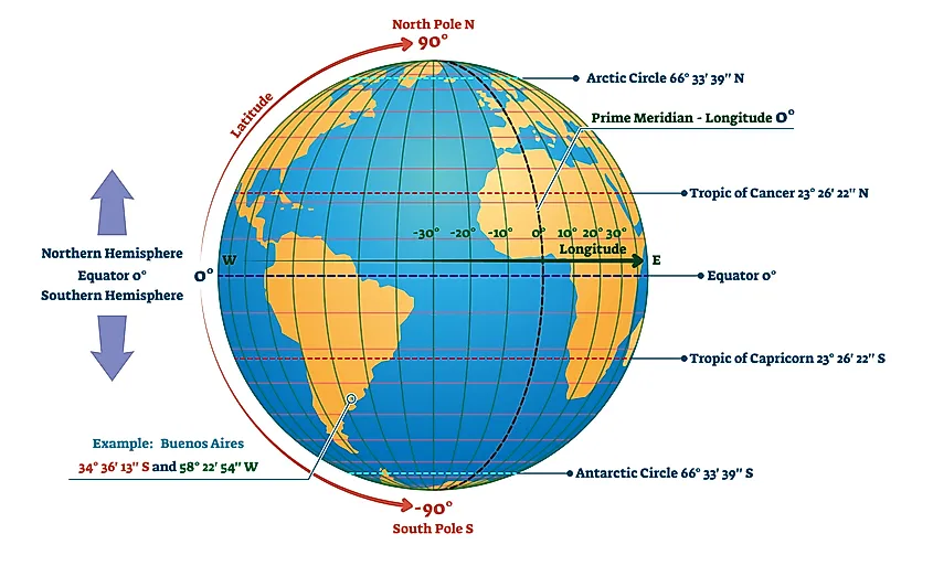
Beyond the parallels you can use to find any specific location, geographers use five major circles of latitude as primary reference lines. These are:
- The Equator (0°)
- The Tropic of Cancer (~23.5° North)
- The Tropic of Capricorn (~23.5° South)
- The Arctic Circle (~66.5° North)
- The Antarctic Circle (~66.5° South)
The image below shows these five circles on a globe.
To familiarise yourself with the definition and location of each circle, please read the following brief text.
Latitudes And Longitudes, Map, Parallels, Meridians, & ...
The article 'Latitudes And Longitudes' from Testbook provides a concise list and description of these five important parallels. This will serve as our foundational definition for each.
Please read the section titled 'Important Parallels of Latitude'. Focus on memorizing the names of the five circles and their approximate latitude in degrees.
2. The Significance of the Tropics and Polar Circles: Earth's Axial Tilt
You might be wondering: why are the Tropics at 23.5° and the Polar Circles at 66.5°? These numbers are not random. They are a direct consequence of the Earth's axial tilt, which, as you may recall from our lesson on seasons, is approximately 23.5°.
This tilt dictates the maximum extent to which the Sun's direct rays reach during the Earth's orbit.
The Tropical Circles (Tropics)
The Tropic of Cancer and Tropic of Capricorn mark the boundaries of the zone where the Sun can be directly overhead.
- Tropic of Cancer (23.5° N): This is the northernmost latitude where the Sun is directly overhead at noon. This event occurs once a year, during the June Solstice (the first day of summer in the Northern Hemisphere).
- Tropic of Capricorn (23.5° S): This is the southernmost latitude where the Sun is directly overhead at noon. This occurs during the December Solstice (the first day of summer in the Southern Hemisphere).
Between these two latitudes, in the region known as "the Tropics," every location experiences the Sun being directly overhead twice a year. Outside of this zone, the Sun is never directly overhead.
The Polar Circles
The Arctic and Antarctic Circles mark the boundaries of the polar regions, which experience extreme variations in daylight throughout the year.
- Arctic Circle (66.5° N): This is the southernmost latitude in the Northern Hemisphere that experiences at least one 24-hour period of continuous daylight (the "midnight sun" during the June Solstice) and at least one 24-hour period of continuous darkness (the "polar night" during the December Solstice).
- Antarctic Circle (66.5° S): This is the northernmost latitude in the Southern Hemisphere that experiences the same phenomena, but during the opposite solstices.
The latitude of these circles is derived directly from the axial tilt: 90° - 23.5° = 66.5°.
To explore these connections in more detail, the following resource provides clear explanations.
The Wikipedia article 'Circle of latitude' offers precise definitions for how the Tropics and Polar Circles are determined by Earth's axial tilt.
Please read the two short sections: 'Polar circles' and 'Tropical circles'. Focus on understanding the link between the axial tilt and the specific phenomena (overhead sun for the Tropics, 24-hour daylight/darkness for the Polar Circles) that define these lines.
3. Climatic Significance: The Earth's Heat Zones
The most important consequence of these circles of latitude is that they provide a framework for dividing the Earth into broad climatic regions, often called heat zones. The angle at which sunlight strikes the Earth determines the intensity of the heat, and these zones reflect the general temperature characteristics of different parts of the world.
There are three main heat zones:
- The Torrid Zone (or The Tropics): Located between the Tropic of Cancer and the Tropic of Capricorn. This zone receives the most direct sunlight throughout the year, making it the hottest part of the Earth. It experiences high temperatures and minimal seasonal variation.
- The Temperate Zones: There are two temperate zones, one in each hemisphere, located between the Tropics and the Polar Circles. In these zones, the Sun is never directly overhead, and its rays always strike at an angle. This results in moderate temperatures and distinct seasons (spring, summer, autumn, winter).
- The Frigid Zones (or Polar Regions): Located within the Arctic and Antarctic Circles. Here, the Sun's rays are at a very oblique angle, resulting in weak solar heating. These are the coldest regions on Earth, characterized by long, cold winters and short, cool summers.

The following video provides an excellent summary of how the major latitudes define these heat zones.
Latitudes and Longitudes | Heat Zones of the Earth | Geography NCERT | UPSC Prelims and Mains 2023
This video from BYJU'S IAS clearly illustrates the five major latitudes and connects them directly to the Torrid, Temperate, and Frigid heat zones.
Watch from 02:37 to 06:09. Pay close attention to how the narrator explains the characteristics of each heat zone based on the amount and angle of sunlight it receives.
Test your understanding!
Imagine you are planning a trip to a city located at 50° South latitude.
- Which of the three main heat zones is this city in?
- Based on its location in this zone, would you expect the Sun to ever be directly overhead at noon?
- What general temperature and seasonal characteristics would you expect?
Show answer
- The city is in the Southern Temperate Zone, as its latitude (50° S) is between the Tropic of Capricorn (23.5° S) and the Antarctic Circle (66.5° S).
- No, the Sun is never directly overhead in the Temperate Zones.
- You would expect moderate temperatures with distinct seasons. Since it is in the Southern Hemisphere, its summer would be from December to February, and its winter would be from June to August.
Conclusion
In this lesson, we have moved beyond simply using latitude for location and have seen how a few key parallels—the Equator, the Tropics of Cancer and Capricorn, and the Arctic and Antarctic Circles—serve as fundamental dividers of our planet.
Key Takeaways:
- There are five major circles of latitude: the Equator (0°), Tropics (~23.5° N/S), and Polar Circles (~66.5° N/S).
- Their specific latitudes are determined by the Earth's axial tilt, defining the limits of the overhead sun (Tropics) and 24-hour daylight/darkness (Polar Circles).
- These circles delineate the three primary heat zones—Torrid, Temperate, and Frigid—which form the basis of Earth's global climate system.
Understanding these lines is a critical step in moving from simply locating places to analyzing the physical processes and patterns that shape our world.
In our next and final lesson of this module, we will synthesize what we've learned about both latitude and longitude. We will discuss the complete grid system they form, known as the geographic graticule, and its essential role in the science of mapping.