Hello! Welcome to the final lesson in our module on Global Climate Systems.
In our last lesson, you did an excellent job of learning to identify and locate the major climate zones on a world map. Using the "hypothetical continent" model, you discovered the predictable patterns of where climates like tropical rainforests, deserts, and Mediterranean zones are found. You learned the "what" and the "where."
Today, we will uncover the "why." This lesson directly addresses the learning outcome: to relate the global distribution of climate zones to atmospheric circulation, pressure belts, and ocean currents. We will connect all the concepts we've explored in this course—from solar energy and pressure systems to wind—to explain the global climate map. This is the capstone lesson for our climatology module, where all the pieces of the puzzle come together.
1. The Engine of Climate: Global Atmospheric Circulation
The ultimate driver of our climate system is the uneven heating of the Earth by the sun. The equator receives far more direct solar energy than the poles. Global circulation is the planet's brilliant solution to this imbalance: it's a massive heat-transfer system that moves energy from the tropics toward the poles.
If the Earth didn't rotate, this system would be simple: one large convection cell in each hemisphere. But because our planet spins, the circulation breaks into a more complex and stable three-cell pattern in each hemisphere. Understanding this model is the first step to explaining why climate zones are where they are.
To see how this works, let's watch a video that introduces these circulation cells.
What is global circulation? | Part Two | The three cells
This video from the Met Office provides a clear, animated explanation of the three-cell model—the Hadley, Ferrel, and Polar cells—and introduces how they create our global climate zones.
Please watch the entire video (it's short, under 3.5 minutes). Pay close attention to: The direction of air movement in each of the three cells (Hadley, Ferrel, Polar). Where the air is rising and where it is sinking.
2. From Circulation to Pressure Belts and Climate Zones
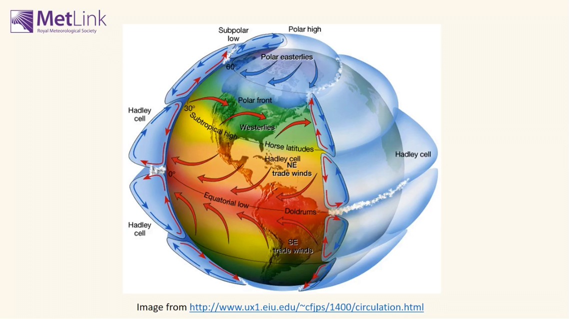
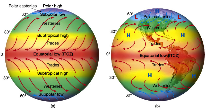
As the video explained, the rising and sinking motions of the air within the Hadley, Ferrel, and Polar cells create distinct bands of high and low pressure across the globe. These pressure belts are the direct cause of the world's major climate zones.
Let's break down this crucial connection:
-
Rising Air = Low Pressure = Rainy Climates:
- At the Equator (Equatorial Low / ITCZ): Warm, moist air in the Hadley cells rises, cools, and condenses, leading to heavy rainfall year-round. This is why we find the world's great tropical rainforests (Af climate) here, in the Amazon, Congo Basin, and Indonesia.
- Around 60° N/S (Subpolar Lows): Cold polar air meets warmer mid-latitude air, forcing it to rise. This zone of convergence and rising air creates ample precipitation, supporting the vast temperate rainforests and boreal forests (Taiga - Dfc climate) of the world.
-
Sinking Air = High Pressure = Dry Climates:
- Around 30° N/S (Subtropical Highs): After rising at the equator, the air in the Hadley cell sinks back to Earth here. The sinking air is dry (it already rained out its moisture at the equator) and it warms as it descends, preventing cloud formation. This creates the perfect conditions for the world's great hot deserts (BWh climate), such as the Sahara, Arabian, and Australian deserts.
- At the Poles (Polar Highs): Extremely cold, dense air sinks. This sinking motion and the air's inability to hold moisture at such low temperatures results in very little precipitation, creating the polar deserts (ET/EF climates) of Antarctica and the high Arctic.
To solidify this link between pressure systems and climate, please read the following short text.
Atmospheric and Oceanic Circulation
This section from the LibreTexts article 'Atmospheric and Oceanic Circulation' provides a detailed written explanation of how the pattern of rising and sinking air directly creates wet and dry climate zones.
Read the section titled 'In addition to their role in creating the surface winds...' down to the paragraph before the one on mountain elevation. Focus on the explanation for why rainy conditions are found at the equator and 60° latitude, and dry conditions at 30° and 90° latitude.
3. From Pressure Belts to Wind Belts
Surface air doesn't just move up and down; it also flows horizontally from areas of high pressure to areas of low pressure. This movement creates the Earth's prevailing wind belts. However, due to the Earth's rotation, these winds are deflected by the Coriolis effect—to the right in the Northern Hemisphere and to the left in the Southern Hemisphere.
This interplay between pressure and the Coriolis effect establishes the major wind systems you've heard about:
- Trade Winds: Blow from the Subtropical Highs (30°) towards the Equatorial Low (0°).
- Westerlies: Blow from the Subtropical Highs (30°) towards the Subpolar Lows (60°).
- Polar Easterlies: Blow from the Polar Highs (90°) towards the Subpolar Lows (60°).
The next video provides a fantastic, step-by-step visual construction of this entire system.
Global Pressures and Wind Belts
This 'Earth Explained' video builds the global pressure and wind system from scratch on a blank globe, which is a great way to see how all the components fit together.
Please watch from the beginning to 08:22. The first part (to 05:30) is a great review of the pressure belts we just discussed. The second part (from 05:30 to 08:22) shows exactly how these pressure belts create the global wind patterns. Notice how the winds are named for the direction they come from.
Test your understanding!
In the last lesson, you learned that the west coasts of continents around 45-55° N latitude (like the UK, or Washington state in the US) typically have a Marine West Coast climate (Cfb) with steady rain all year.
Using what you've just learned about pressure and winds, can you explain why?
Show answer
There are two main reasons:
- Wind Belt: These regions lie in the path of the Westerlies. These winds blow from west to east, carrying moist air from the ocean over the land.
- Pressure Belt: They are located near the Subpolar Low pressure belt (around 60°N), a zone where air converges and rises, promoting cloud formation and precipitation year-round.
4. The Final Piece: The Role of Ocean Currents
The oceans are not static. Winds blowing over their surface, along with differences in water density (due to temperature and salinity), drive a global system of ocean currents. These currents act as enormous rivers within the ocean, transporting vast amounts of heat and profoundly influencing the climate of adjacent landmasses.
Let's explore how this works.
Atmospheric and Oceanic Circulation
We'll return to the LibreTexts article to understand how ocean currents are formed and how they modify regional climates.
Please read the two sections under the heading 'Ocean Circulation'. The first part explains how winds drive surface currents (gyres). The second part discusses the deeper, density-driven 'thermohaline circulation'. Focus on the general principles and the examples given.
The key takeaway is the difference between warm and cold currents:
-
Warm Currents: These typically flow from the tropics towards the poles along the east coasts of continents (in the subtropical regions) and then cross the ocean. The Gulf Stream is a famous example. It brings warm water from the Gulf of Mexico across the Atlantic (as the North Atlantic Drift), making Western Europe significantly warmer than it would otherwise be for its latitude. This is why London has a temperate climate (Cfb) while parts of Canada at the same latitude have a much harsher subarctic climate (Dfc).
-
Cold Currents: These typically flow from the poles towards the equator along the west coasts of continents. These currents have a stabilizing effect on the air above them, inhibiting cloud formation and rainfall. They are a major contributing factor to the formation of some of the world's driest coastal deserts. For example, the cold Humboldt (Peru) Current helps create the extreme dryness of the Atacama Desert, and the cold Benguela Current does the same for the Namib Desert in Africa.
Conclusion
Today, you have assembled the complete picture of what drives Earth's climate system. You've seen how the simple fact of unequal solar heating gives rise to a complex, interconnected system of atmospheric cells, pressure belts, wind patterns, and ocean currents. It is this grand, dynamic system that dictates why tropical rainforests grow on the equator, why deserts form in the subtropics, and why western Europe is milder than eastern Canada. You have moved from knowing what and where to understanding why.
Key Takeaways:
- The three-cell model (Hadley, Ferrel, Polar) describes the atmospheric circulation that transports heat from the equator to the poles.
- Rising air in these cells creates low-pressure belts (at 0° and 60°) associated with rainy climates, while sinking air creates high-pressure belts (at 30° and 90°) associated with dry climates.
- Pressure differences, combined with the Coriolis effect, create the global wind belts (Trades, Westerlies, Easterlies).
- Ocean currents, driven by winds and density, act as a second heat-transfer system, with warm currents warming and humidifying coastlines, and cold currents cooling and drying them.
Preview of the Next Module:
This lesson has been a perfect bridge to our next topic. We've seen how critical the oceans are in regulating global climate. The next module, The Hydrosphere: Oceans and the Water Cycle, will dive deeper into this realm. We will begin by looking at the total distribution of water on Earth and the processes of the global hydrological cycle that we've touched upon today.