Hello! Welcome to the next lesson in our exploration of atmospheric dynamics.
In the previous lesson, we learned how to read a weather map, identifying high and low-pressure systems and understanding what isobars represent. We also touched on a critical idea: the spacing of isobars gives us a clue about wind speed.
Today, we will formalize and deepen that understanding. This lesson is dedicated to the learning outcome: Describe the relationship between pressure gradients and wind speed. We'll explore the primary force that gets air moving in the first place—the Pressure Gradient Force. This is the engine that drives the wind.
By the end of this lesson, you will be able to:
- Define the pressure gradient and the Pressure Gradient Force (PGF).
- Explain precisely how the pressure gradient controls wind speed.
- Visually determine where winds are strong or weak on a weather map using isobars.
- Apply this concept to understand a real-world wind system: the land and sea breeze.
1. The Force That Creates Wind
At its most basic, wind is simply the movement of air. This movement is the atmosphere's attempt to balance inequalities. Specifically, air flows from areas of higher pressure to areas of lower pressure. But for this to happen, there must be a force involved. This force is called the Pressure Gradient Force (PGF).
A "gradient" is a term used in science to describe how much a quantity changes over a certain distance. Therefore, a pressure gradient is the rate of change of atmospheric pressure between two points.
The following reading provides a concise, systematic explanation of how energy differences on Earth's surface ultimately create this pressure gradient, which in turn creates wind.
Controls over wind direction and speed
Let's begin with a clear definition from the online textbook 'The Physical Environment'. This section establishes the fundamental cause-and-effect relationship that leads to wind.
Please read the section titled 'Pressure Gradient'. Focus on the logical flow presented: how an energy gradient leads to a temperature gradient, which creates a pressure gradient, which finally results in wind.
The key takeaway is that the Pressure Gradient Force (PGF) is what initiates the movement of air. It always acts directly from higher pressure toward lower pressure, perpendicular to the isobars.
2. Isobar Spacing and Wind Speed
Now for the central point of our lesson: The speed of the wind is determined by the strength (or steepness) of the pressure gradient.
- A steep or strong pressure gradient means that pressure changes rapidly over a short distance. This creates a strong PGF and results in high-speed winds.
- A weak pressure gradient means that pressure changes slowly over a long distance. This creates a weak PGF and results in light winds.
On a weather map, the spacing of the isobars is our visual indicator of the pressure gradient.

Looking at the image above, you can see a tangible example. With your background in basic calculus, you can think of the pressure gradient as being conceptually similar to a derivative—it's a rate of change (change in pressure / change in distance). The bottom diagram shows a large change in pressure over a small distance (a steep gradient, like a large derivative), which drives strong winds.
The next image provides another powerful visual analogy.
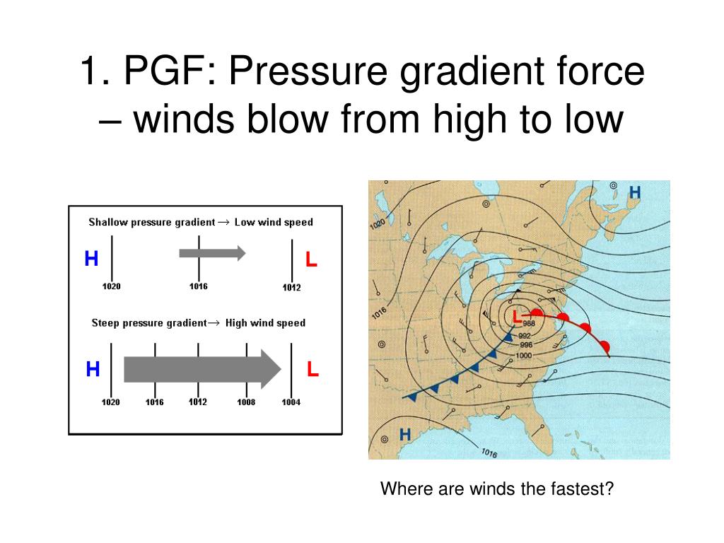
Before moving on, look at the weather map on the right side of the image above. Based on the isobar spacing, where would you expect the winds to be the fastest? You should be able to see that the isobars are packed most tightly to the west and north of the low-pressure center (L), indicating the strongest winds would be in that area.
Test your understanding!
Imagine you are looking at a weather map showing two different cyclones (low-pressure systems) over the ocean.
- Cyclone Alpha has a central pressure of 980 mb, and the isobars around it are spaced approximately 150 km apart.
- Cyclone Beta also has a central pressure of 980 mb, but the isobars around it are spaced only 30 km apart.
Which cyclone is producing stronger winds? Explain your reasoning based on the concept of the pressure gradient.
Show answer
Cyclone Beta would be producing much stronger winds.
Reasoning: The wind speed is determined by the pressure gradient, which is represented by the spacing of the isobars. Cyclone Beta has isobars that are much more closely spaced (30 km apart vs. 150 km apart). This indicates a much steeper pressure gradient. A steeper pressure gradient creates a stronger Pressure Gradient Force (PGF), which in turn drives faster winds. Even though their central pressures are the same, the pressure changes much more rapidly around Cyclone Beta.
3. A Real-World Example: Land and Sea Breezes
The concept of a pressure gradient isn't just for large-scale weather systems. It operates on local scales as well, creating familiar daily wind patterns. The classic example is the land and sea breeze common in coastal areas. This phenomenon is a direct result of a thermally-induced pressure gradient.
The following video explains this process clearly. It will serve as both a recap of the PGF and an excellent practical application.
Meteorology: Pressure Gradients Explained
This video from MS Meteorology first provides a great summary of the Pressure Gradient Force, and then applies it to explain the formation of sea and land breezes.
Please watch this video from the beginning to the end. The first part (0:00 - 2:31) reinforces the core relationship between isobar spacing and wind speed. The second part (3:32 - 6:13) explains how the differential heating of land and sea creates daily pressure gradients that drive sea breezes (daytime) and land breezes (nighttime).
This daily cycle is a perfect miniature model of how the atmosphere works:
- Unequal Heating: During the day, land heats up faster than water.
- Temperature Gradient: The air over the land becomes warmer than the air over the water.
- Pressure Gradient: Warm air over the land rises, creating a zone of lower pressure. The cooler, denser air over the water creates a zone of higher pressure.
- Wind: The PGF pushes air from the high pressure over the sea to the low pressure over the land, creating a "sea breeze." At night, the process reverses.
Conclusion
Today, you've mastered a truly fundamental principle of meteorology. You've moved beyond simply identifying pressure systems to understanding the very force that generates wind and controls its speed.
Key Takeaways:
- The primary driver of wind is the Pressure Gradient Force (PGF), which pushes air from areas of high pressure to low pressure.
- The pressure gradient is the rate of pressure change over distance.
- Wind speed is directly proportional to the steepness of the pressure gradient. A steeper gradient means a stronger PGF and faster winds.
- On a weather map, a steep pressure gradient is shown by closely spaced isobars, while a weak gradient is shown by widely spaced isobars.
Preview of the Next Lesson:
We have established that the PGF pushes air directly from high to low pressure. If this were the only force acting on the wind, all winds would blow in a straight line, directly across the isobars. But we know from looking at weather maps that winds spiral around high and low-pressure systems. Why?
In our next lesson, we will answer this question by introducing the second major force that influences wind: the Coriolis effect. You'll learn how Earth's rotation deflects moving air, turning the simple straight-line motion from the PGF into the complex, swirling patterns we see in our global weather systems.