Hello! Welcome back to our final lesson on the Hydrosphere.
In our previous lesson, we analyzed the large-scale, stable patterns of ocean circulation: the wind-driven surface gyres and the density-driven "Global Conveyor Belt." We treated these as a steady-state system. However, the ocean-atmosphere system is dynamic and variable.
Today, we will explore the single most important year-to-year variation in this system. This lesson fulfills the learning outcome: Explain the formation and climatic impacts of the El Niño-Southern Oscillation (ENSO) phenomenon. We'll investigate how a periodic change in the winds and ocean temperatures in the tropical Pacific can trigger a chain reaction, leading to droughts, floods, and significant weather anomalies across the globe. This is a cornerstone topic in climatology, an area you've expressed a keen interest in.
1. What is ENSO? The "Normal" State
ENSO stands for El Niño-Southern Oscillation. The name itself reveals its dual nature:
- El Niño refers to the oceanic component: an unusual warming of the surface waters in the eastern tropical Pacific.
- Southern Oscillation refers to the atmospheric component: a see-saw of atmospheric pressure between the eastern and western Pacific.
These two phenomena were once studied separately but are now understood to be two sides of the same coin—a coupled ocean-atmosphere interaction. To understand what happens when the system is disrupted, we must first understand its "normal" or neutral state. This state is governed by a circulation pattern known as the Walker Circulation.
What is ENSO, El nino, La nina, Southern Oscillation, Walker Circulation | UPSC / IAS
To start, let's watch a clear, step-by-step explanation of this neutral phase. This video from Amit Sengupta provides an excellent foundation.
Watch the section from 01:20 to 03:37. Focus on how the trade winds, ocean temperatures, and air pressure work together to create a circulation loop across the Pacific.
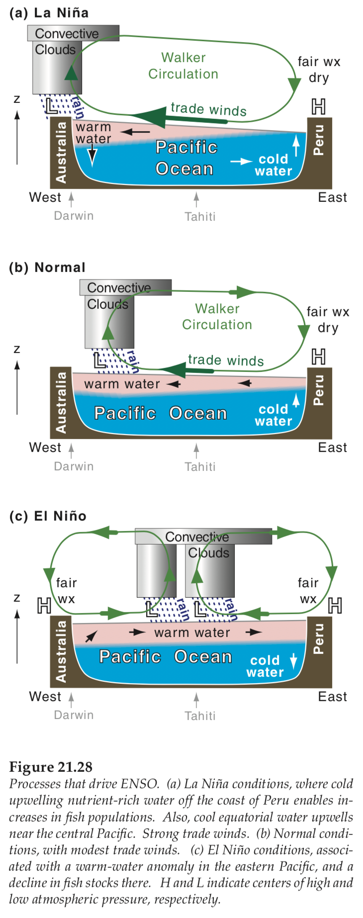
As the video explained, the Walker Circulation is a large atmospheric loop over the equatorial Pacific driven by a temperature and pressure gradient. Here's a breakdown of the key elements in the neutral phase:
- Strong Trade Winds: The easterly trade winds blow consistently from east to west across the tropical Pacific.
- Water "Piling Up": These winds push the warm surface water towards the western Pacific (near Indonesia and Australia). This creates a "warm pool" of water that is slightly higher in sea level than the eastern Pacific.
- Upwelling in the East: As surface water is pushed west, cold, nutrient-rich water from the deep ocean rises to the surface off the coast of South America (Peru and Ecuador). This process is called upwelling.
- Atmospheric Response:
- The warm water in the west heats the air above it, causing it to rise. This creates a persistent low-pressure system with clouds and heavy rainfall.
- The cold water in the east cools the air above it, causing it to sink. This creates a persistent high-pressure system with dry, clear conditions.
- The Loop is Closed: The rising air in the west flows eastward at high altitudes, sinks in the east, and then flows back to the west at the surface as the trade winds, completing the loop.
2. The El Niño Phase: A Reversal of Fortunes
Every few years, for reasons not yet perfectly understood, the Walker Circulation weakens or even reverses. This marks the beginning of an El Niño event.
What is ENSO, El nino, La nina, Southern Oscillation, Walker Circulation | UPSC / IAS
Let's return to the same video to see how the system changes during an El Niño.
Watch the section from 03:24 to 05:04. Pay close attention to the crucial change: the weakening of the trade winds and the consequences that follow.
During an El Niño, the entire system flips:
- Weakened Trade Winds: The easterly trade winds weaken significantly.
- Eastward Water Movement: Without the strong winds to hold it back, the large pool of warm water from the western Pacific begins to slosh back eastward across the ocean.
- Suppressed Upwelling: This layer of warm water spreads over the eastern Pacific, cutting off the upwelling of cold water along the coast of South America. The sea surface temperature there becomes much warmer than average.
- Atmospheric Reversal (The "Southern Oscillation"):
- The zone of rising warm air, low pressure, and rainfall shifts eastward with the warm water, now centered over the central or eastern Pacific.
- This leaves the western Pacific (Indonesia, Australia) under the influence of sinking air and high pressure, leading to drier conditions and often drought.
This change in the pressure pattern is the "Southern Oscillation." A negative value on the Southern Oscillation Index (SOI), which measures the pressure difference between Tahiti (east) and Darwin, Australia (west), indicates El Niño conditions.
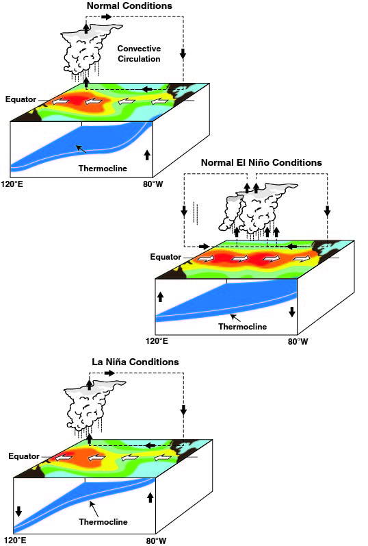
Diagrams of Walker Circulation during El Niño and La Niña
This resource from NOAA provides excellent visualizations. Look at the top image, "Generalized Walker Circulation... during El Niño events." It shows how the normal rising and sinking branches of the circulation have shifted eastward, bringing rain to the central/eastern Pacific and dryness to the west.
3. The La Niña Phase: An Amplified "Normal"
A La Niña event is essentially an intensification of the normal Walker Circulation.
What is ENSO, El nino, La nina, Southern Oscillation, Walker Circulation | UPSC / IAS
Finally, let's see what happens during a La Niña.
Watch the final segment from 05:04 to 06:13. Notice how this phase is described as being similar to the neutral phase, but with stronger effects.
During a La Niña, we see:
- Stronger-than-average Trade Winds: The east-to-west trade winds become even more powerful.
- Enhanced Water Movement: This pushes more warm water into the western Pacific and enhances the upwelling of very cold water in the eastern Pacific. The temperature difference across the Pacific becomes exaggerated.
- Intensified Atmospheric Pattern: The low-pressure system in the west becomes even stronger, leading to heavier-than-usual rainfall and flooding in Southeast Asia and Australia. The high pressure in the east becomes more pronounced, leading to even drier conditions along the coast of South America.
Test your understanding!
A fisherman off the coast of Peru reports that the water is unusually cold and his fish catch, which thrives in cold, nutrient-rich water, is exceptionally good. At the same time, news reports mention severe droughts and wildfires in Australia. Which phase of ENSO are these conditions most consistent with?
Show answer
These conditions are most consistent with a strong La Niña event. The unusually cold water off Peru indicates enhanced upwelling, and the droughts in Australia are a classic sign of the intensified high-pressure system in the western Pacific during La Niña.
4. Global Climatic Impacts of ENSO
The changes during El Niño and La Niña are so significant that they disrupt global atmospheric circulation, causing ripple effects, or teleconnections, far from the tropical Pacific.
To understand these widespread impacts, let's read a summary of the effects from both the Ramsaday College lecture notes and the NOAA FAQ page.
First, read the section 'Impact of El-Nino' and 'Impact of La-Nina' in the 'Walker Circulation, El Niño...' resource. This will give you a list of regional impacts. Then, to understand how these happen, read the section 'How do El Niño and La Niña affect weather patterns?' in the NOAA FAQ resource. Focus on how ENSO modifies the mid-latitude jet streams.
Here's a summary of the key global impacts:
-
Americas:
- El Niño: Brings warmer, wetter winters to the southern US and the coast of South America (causing floods in Peru). The Pacific Northwest and northern US tend to be warmer and drier.
- La Niña: Causes drought in the southern US and wetter conditions in the Pacific Northwest. The coast of Peru becomes very dry.
-
Asia and Australia:
- El Niño: Often brings severe drought, crop failure, and increased bushfire risk to Australia, Indonesia, and parts of southern Asia.
- La Niña: Typically brings heavy rainfall and widespread flooding to these same regions.
-
Hurricane Activity:
- El Niño: Increases wind shear over the Atlantic, which suppresses hurricane development. However, it encourages hurricane formation in the central and eastern Pacific.
- La Niña: Decreases wind shear in the Atlantic, leading to a more active hurricane season. It suppresses hurricane formation in the central and eastern Pacific.
-
Global Average Temperature:
- Because El Niño releases a vast amount of heat from the ocean into the atmosphere, years with strong El Niño events are often among the warmest on record globally.
- La Niña, conversely, involves the ocean absorbing more heat from the atmosphere, and La Niña years tend to be globally cooler than the surrounding trend.
Conclusion
Today you've learned about the El Niño-Southern Oscillation, a powerful and naturally occurring climate pattern that demonstrates the profound connection between the ocean and the atmosphere. You are now able to explain its formation and its far-reaching climatic impacts.
Key Takeaways:
- ENSO is a coupled ocean-atmosphere cycle with three phases: Neutral (Walker Circulation), El Niño (warm phase), and La Niña (cool phase).
- The Neutral phase is characterized by strong trade winds blowing west, causing warm, wet conditions in the western Pacific and cool, dry conditions with upwelling in the eastern Pacific.
- El Niño is triggered by weakened trade winds, allowing warm water to shift eastward. This reverses the normal patterns, bringing rain to the central/eastern Pacific and drought to the west.
- La Niña is an intensification of the normal pattern, with stronger trade winds exaggerating the wet conditions in the west and dry conditions in the east.
- Through atmospheric teleconnections, ENSO influences global weather, affecting jet streams, temperature, precipitation, and storm activity around the world.
Preview of the Next Module:
This lesson concludes our module on the Hydrosphere. We have journeyed from the Earth's water budget and ocean properties to the vast systems of currents that regulate our climate.
In our next module, we will shift our focus from the fluids that cover our planet to the ground beneath our feet. We will begin our study of the Solid Earth by exploring the layered internal structure of the Earth and tracing the development of the revolutionary theory of plate tectonics.