Last lesson, you located Hormuz between the Persian Gulf and the Gulf of Oman, with Iran on one side and Oman’s Musandam Peninsula on the other. This lesson moves from the coastline to the route ships actually use. You will distinguish the width of the strait from the width of its shipping lanes, then see why concentrating traffic near the coasts makes Hormuz a strategic chokepoint—without assuming that a narrow lane makes the entire strait easy to close.
The strait is wider than its shipping lanes
A ship leaving the Persian Gulf cannot simply head toward open water in any direction. To reach the Gulf of Oman by sea, it must pass through Hormuz. That is the geographical constraint. Within the passage, large ships ordinarily follow designated routes that separate traffic moving in opposite directions. That is the navigational constraint.
Watch this brief map sequence for a visual introduction to the two lanes. Its rounded measurements are less important than the distinction between the whole passage and the routes vessels follow.
Why the US and Iran are fighting over this tiny waterway
Watch “Why the US and Iran are fighting over this tiny waterway” from Vox to see the strait and its paired shipping corridors on a map.
Watch the route map, beginning when the narrator locates Hormuz between Oman and Iran and ending after the two designated corridors are described. Notice that the corridors occupy only part of the waterway.
The U.S. Energy Information Administration (EIA) gives an approximate width of 21 miles (34 kilometres) at the strait’s narrowest point. It describes a shipping lane two miles wide in each direction, with a two-mile buffer separating the lanes. Taken together, those designated lanes and their buffer occupy roughly six miles across. The six-mile figure describes a traffic arrangement, not the full width of the strait or a physical wall across it.
Read the EIA’s description to establish the difference between the strait’s overall width and the lanes used by ships.
In the paragraph beginning “The Strait of Hormuz is the world’s most important chokepoint,” find the sentence beginning “At its narrowest point.” Read the lane description. Focus on which measurement refers to the waterway and which measurements refer to the organized traffic routes. The dated oil and gas figures in the preceding sentences are for a later lesson.
These lanes are part of a Traffic Separation Scheme, or TSS. Its purpose is to organize opposing streams of vessels rather than have them meet at random in a confined area. A useful comparison is a marked road with traffic travelling in opposite directions, provided you remember its limit: shipping lanes are routes on water, not solid barriers that make all other water impassable.
Read the traffic pattern against the coast
The chart below shows the scheme in its geographical setting. The pink bands and white arrows depict the principal traffic routes and their directions. The land near the bottom is the Musandam Peninsula; the coastline and islands toward the top are on the Iranian side.
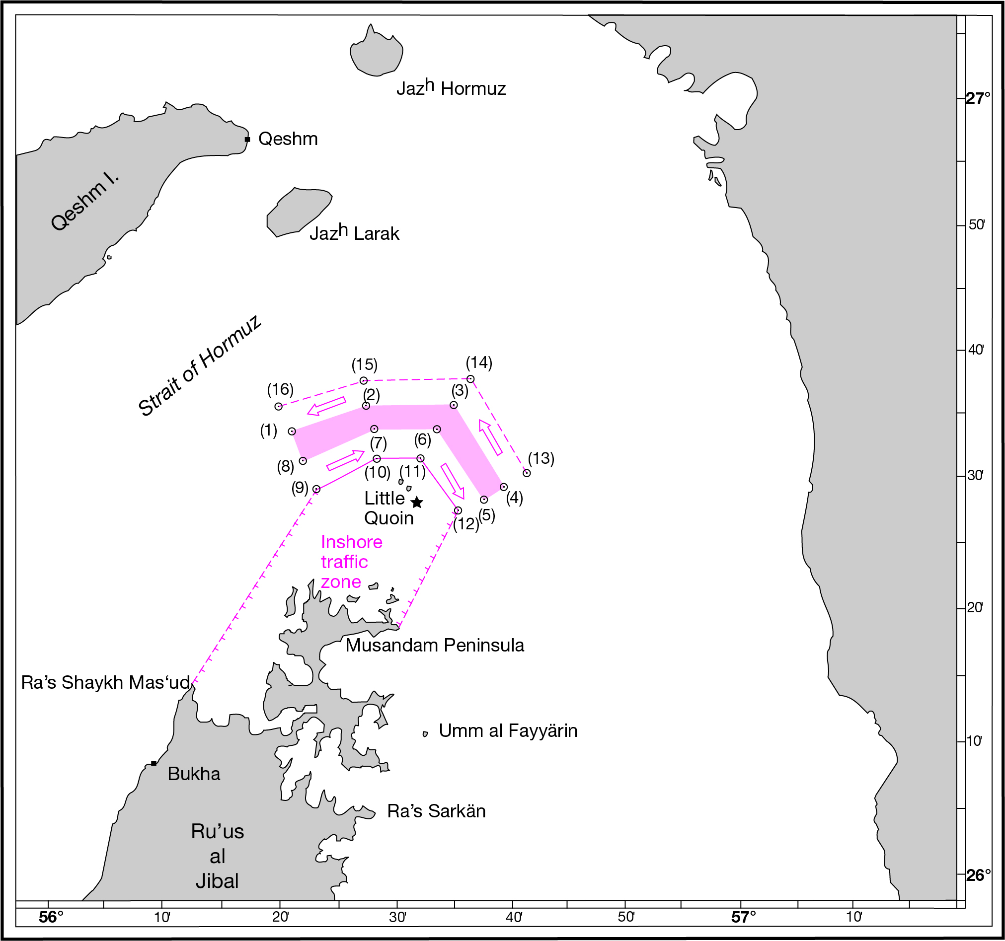
Follow a white arrow along one pink band, then find an arrow travelling the other way. The bends matter as much as the widths: ships follow a defined course through waters bordered by land and islands, rather than spreading evenly across the opening. The chart also labels an inshore traffic zone beside Musandam. It is distinct from the principal lanes; its presence does not mean that every large tanker can—or normally does—use it as a substitute route.
The proximity of the routes to shore has practical consequences. A vessel encountering a hazard in a busy, confined route cannot be understood as though it were alone on an open ocean: other ships are using the opposing or same-direction routes, while the coastline and islands constrain the surrounding space. A problem affecting a commonly used lane can therefore cause ships to slow, wait, or alter their movements. Neither the pink bands nor the dashed chart markings should be read as national borders or as an explanation of passage rights. Those legal questions come later in the course.
Why this is a chokepoint—and what that does not imply
A chokepoint is a narrow part of a widely used route where a disruption can affect traffic far beyond the immediate area. The EIA explains the general idea in terms of delayed supplies and increased shipping costs.
Return to the EIA article for its explanation of why a narrow passage matters to trade, beyond the difficulty of navigating it.
Near the beginning of the article, after the paragraph about maritime oil movements in 2015, read the chokepoint explanation. Focus on the distinction between interrupting a route and immediately eliminating the supplies being carried on it.
Hormuz combines two kinds of concentration. Geography channels ships travelling between the Persian Gulf and the Gulf of Oman through one passage. Traffic organization places many of those ships into a small number of directional lanes within that passage. Its strategic importance also depends on what the ships carry: substantial oil and gas exports travel this way, a scale you will examine with dated figures in the next lessons.
There is an important limit to the picture. Disrupting a usual shipping lane is not identical to sealing the whole strait. The Strauss Center notes that water outside the TSS can be deep enough for even very large tankers. A hazard in a lane could seriously disturb normal movements, but a claim that no ship can pass Hormuz requires stronger evidence than a claim that traffic in the usual route has been impeded.
Strait of Hormuz - About the Strait - Strauss Center
Read the Strauss Center’s account for both the purpose of the Traffic Separation Scheme and the crucial qualification about navigable water outside it.
On the “About the Strait” page, skip the opening estimate of the strait’s overall width and begin at “In order to regulate the movement of large ships.” Read both paragraphs, ending with the explanation of why a barrier would have to extend beyond the TSS to obstruct the wider strait. This page and the EIA give different estimates of the strait’s minimum overall width; rely on their shared description of the lane layout rather than treating those overall-width figures as identical measurements.
This distinction helps interpret reports of an incident. A threat near a lane, a temporary pause in departures, and a sustained inability to pass are different conditions. The geography makes all of them consequential, but it does not make them interchangeable.
Key takeaways
Hormuz is a chokepoint because ships connecting the Persian Gulf to the Gulf of Oman pass through a restricted geographical opening, while a Traffic Separation Scheme concentrates much of their movement into two approximately two-mile-wide directional lanes with a buffer between them. Those routes run near coasts and islands, making interference with normal traffic potentially significant. Yet the lanes are narrower than the navigable strait: an obstructed lane does not, by itself, prove that the entire waterway is closed.
Next, you will put numbers to the energy traffic moving through this route, separating its share of worldwide oil consumption from its share of oil traded by sea.