Welcome to the module on sovereignty and passage. The Strait of Hormuz raises a legal question alongside its geographic and economic importance: if the waters in a narrow strait fall within coastal states’ territorial seas, can foreign ships still pass through? This lesson uses a simplified map and the relevant provisions of the United Nations Convention on the Law of the Sea (UNCLOS) to distinguish coastal-state sovereignty, innocent passage, and transit passage. Allow about 40 minutes, including the short video segments and targeted readings.
A narrow strait, but not a closed waterway
Iran lies on the northern shore of Hormuz; Oman’s Musandam Peninsula lies on the southern shore. The image below compares two simplified territorial-sea maps. In the left panel, narrower three-nautical-mile belts leave a central corridor outside either state’s territorial sea. In the right panel, twelve-nautical-mile belts reach across the strait’s narrowest span, leaving no such corridor there.
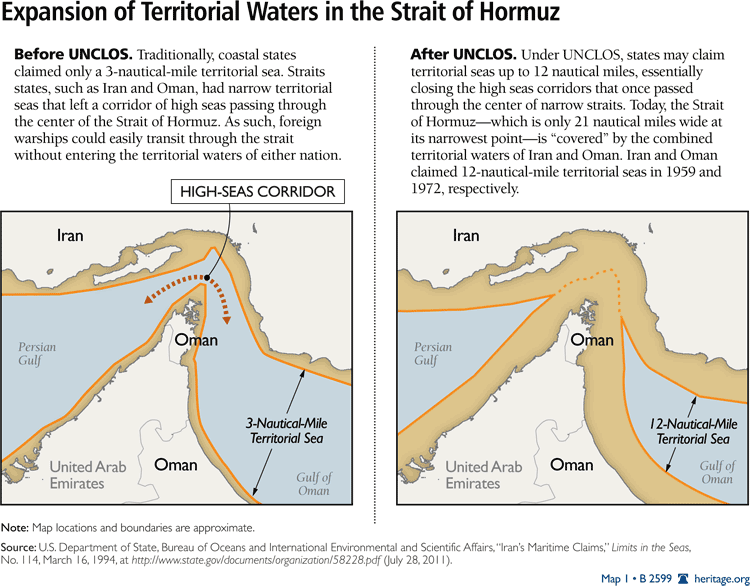
The distinction between water under a state’s sovereignty and water foreign ships may lawfully cross is the key to the lesson. Losing a high-seas corridor does not mean losing a right to navigate through the strait.
Treat the image as a conceptual guide, not a precise navigation chart or a complete legal history. Territorial-sea limits are measured from legally defined baselines, not simply from the visible shore; islands and the delimitation of opposite coasts matter. Nor did UNCLOS suddenly create every twelve-nautical-mile claim: the image itself dates Iran’s and Oman’s claims to before the convention was adopted. Most importantly, overlapping twelve-mile measurements do not give both states sovereignty over the same water at once. The boundary between opposite territorial seas must be delimited.
Why No One Truly "Owns" the Strait of Hormuz
Watch “Why No One Truly ‘Owns’ the Strait of Hormuz” from What’s Going on With Shipping? for a geographic view of the territorial-sea issue.
Watch the strait map for the shores, shipping lanes, and territorial-water claims. Then watch the territorial sea for the meaning of the twelve-nautical-mile limit. Keep the map’s simplified boundaries separate from the exact course of any vessel.
UNCLOS sets out what the territorial sea means legally. Read the short provisions below with the image in view.
UNITED NATIONS CONVENTION ON THE LAW OF THE SEA
Read the United Nations’ text for the extent of coastal sovereignty, the twelve-nautical-mile limit, and the basic rule for opposite coasts.
In Part II, Section 1, “General Provisions,” read Article 2, “Legal status of the territorial sea,” from sovereignty. In Section 2, “Limits of the Territorial Sea,” read Article 3, “Breadth of the territorial sea,” from the breadth rule. Finally, find Article 15, “Delimitation of the territorial sea between States with opposite or adjacent coasts.” Read its first sentence from opposite coasts; the median-line idea matters here more than the boundary’s exact location.
Sovereignty is the coastal state’s governing authority over its territorial sea, including the airspace above it and the seabed beneath it. Article 2 also states the qualification that prevents a mistaken reading of the map: that sovereignty is exercised subject to UNCLOS and other rules of international law. A territorial sea is therefore neither high seas nor a zone in which the coastal state may disregard every right of foreign passage.
Innocent passage: a right through a territorial sea
For a ship navigating another state’s territorial sea, UNCLOS provides a general right called innocent passage. “Passage” concerns navigation through that sea or travel to or from a port or internal waters. It should be continuous and expeditious, though an ordinary navigational stop—or one required by distress—can still count as passage.
“Innocent” describes what the ship does, not whether its cargo or flag is politically welcome. Its passage must not be prejudicial to the coastal state’s peace, good order, or security. A vessel simply sailing through is different from one conducting weapons practice, collecting security intelligence, fishing, or carrying out a survey in the territorial sea.
UNITED NATIONS CONVENTION ON THE LAW OF THE SEA
Continue with the United Nations’ Part II text to see both the ship’s right and the limits on its conduct.
In Section 3, “Innocent Passage in the Territorial Sea,” Subsection A, read Articles 17–18, “Right of innocent passage” and “Meaning of passage,” from passage and stops. Continue through Article 19, “Meaning of innocent passage,” from innocent conduct; focus on the general test and a few examples, rather than memorizing the list. In Article 20, note the surface rule. Then find Articles 24–25, “Duties of the coastal State” and “Rights of protection of the coastal State.” Read from coastal powers, noting the conditions attached to any temporary suspension.
This is a right of passage for ships, not a transfer of sovereignty to them. Conversely, sovereignty does not make passage dependent on a coastal state’s unrestricted permission. UNCLOS permits a coastal state to act against passage that is not innocent. It also allows a narrowly conditioned, published, temporary suspension of innocent passage in specified areas of an ordinary territorial sea when essential for security. That last rule must not be carried over automatically to an international strait: UNCLOS gives certain straits their own passage regime.
Transit passage: the rule for a qualifying international strait
Hormuz connects waters used for international navigation on either side of the strait. Under the UNCLOS framework, a strait used for international navigation between one area of high seas or exclusive economic zone and another generally falls under transit passage. This is why drawing territorial seas over the channel does not settle the navigation question.
Transit passage permits ships and aircraft to navigate through or over a qualifying strait for continuous and expeditious transit. It is a right exercised within rules, not a declaration that the territorial sea has become high seas. The bordering states retain sovereignty or jurisdiction, but exercise it subject to the strait-passage provisions. In particular, UNCLOS says they must not hamper transit passage and that there shall be no suspension of it.
Why No One Truly "Owns" the Strait of Hormuz
Return to the shipping video for its explanation of transit passage in Hormuz.
Watch transit passage, focusing on the difference between a coastal state’s territorial claim and a ship’s right to cross the strait. The video also discusses the position of states that have not joined UNCLOS; set that separate, contested question aside for the later lesson on national legal positions.
UNITED NATIONS CONVENTION ON THE LAW OF THE SEA
Read the United Nations’ straits provisions to connect the map to the legal rule, and to see why not every strait is treated identically.
In Part III, Section 1, “General Provisions,” find Article 34, “Legal status of waters forming straits used for international navigation.” Read from sovereignty retained. In the same section, Article 36, “High seas routes or routes through exclusive economic zones,” read from the route exception. In Section 2, “Transit Passage,” read Articles 37–38, “Scope of this section” and “Right of transit passage,” from the transit rule. Near the end of Section 2, find Article 44, “Duties of States bordering straits,” and read from no suspension.
Article 36 supplies an important limit on the simplified Hormuz picture. If a strait has a comparably convenient route through high seas or an exclusive economic zone, the convention applies other navigation rules to that route rather than the transit-passage regime. The test is not merely whether two strips labeled “territorial sea” touch on a diagram; the strait’s use and the available route matter.
Part III also retains innocent passage for certain international straits that do not fall under transit passage. Article 45 identifies those cases and says innocent passage through those straits cannot be suspended. This differs from the conditional suspension rule for ordinary territorial seas discussed above. Hormuz is the example here of a strait for which the transit-passage framework, rather than that exceptional innocent-passage framework, is central.
Reading the map with the three concepts
The same patch of water can be described from two different legal perspectives: whose territorial sea it is, and what right a vessel has while crossing it. The map answers the first question only approximately. The vessel’s route and purpose, together with the applicable strait rules, answer the second.
| Concept | What it identifies | What it does not mean |
|---|---|---|
| Coastal-state sovereignty | The bordering state’s authority over its territorial sea, subject to international law | An unlimited power to stop all foreign passage |
| Innocent passage | A right for ships to navigate a territorial sea without conduct prejudicial to the coastal state | A right to fish, survey, or conduct weapons practice while passing |
| Transit passage | Navigation and overflight for continuous, expeditious transit through a qualifying international strait | A high-seas corridor or the disappearance of coastal-state sovereignty |
Look once more at the right-hand panel of the Hormuz image. The absence of a central high-seas corridor tells you why passage rights matter so much; it does not tell you that ships must stop at the edge of territorial waters. Under the UNCLOS transit-passage framework, the coastal states retain sovereignty over their respective waters while qualifying ships have a right to cross the strait without that passage being suspended. Exact boundaries and the legal treatment of a particular voyage require more than this schematic map.
Conclusion
Three ideas should now stay separate when reading about Hormuz. Territorial sea identifies coastal sovereignty; innocent passage is a general, conduct-limited right for ships in territorial seas; and transit passage protects continuous navigation and overflight through qualifying international straits without suspending that passage. The expansion depicted on the map changes the legal status of the central water, not the existence of a route through it.
The next lesson applies the transit-passage rules to a merchant ship and a coastal state, focusing on what each must do during an actual crossing.