Recommended resources
The freely available resources this lesson will direct you to.
- Before the Ashes: The Rise of Pompeii the Roman Supercity - Full Documentarywww.youtube.com
- Exploring the Archaeological Site of Pompeii | with forensic expert Dr Estelle Lazerwww.youtube.com
- Along the streets of Pompeii - Pompeii Sitespompeiisites.org
- A Guide to the Pompeii Excavationspompeiisites.org
Hello. This course approaches Pompeii as an archaeological record: a place whose streets, buildings, objects, and deposits can be studied together, but whose evidence needs careful interpretation. In this first module, you will establish where the city stood before moving on to its history and the kinds of evidence it preserves.
Today, the aim is to build a reliable mental map. You will locate Pompeii in the Bay of Naples, identify its principal urban features, and explain why its plateau, river, routes, and nearby volcano mattered. Allow about 35–40 minutes, including the readings and map study.
A city between a volcano, a river, and a bay
Start at the regional scale. Pompeii stood southeast of Mount Vesuvius, near the southern side of the Bay of Naples. Herculaneum lay nearer the volcano’s western side; Pompeii occupied a different position, close to the valley and mouth of the River Sarno. The map shows these relationships more clearly than a description of the city alone can.

Pompeii itself occupied a raised plateau above the Sarno valley. Elevation offered a view over approaches to the settlement and helped separate the inhabited area from the lower river plain. Yet the city was not isolated on a hilltop: routes connected it to the fertile valley, the river, and the bay. Its position made sense both for an enclosed settlement and for a community involved in regional exchange.
Read the opening of the archaeological site’s guide for the physical setting. Keep its geographical claims separate from the later historical events in the same section; we will build a timeline in the next lesson.
A Guide to the Pompeii Excavations
Read the opening of “A brief history of the ancient city and the excavations,” published by Pompeii Sites, to establish the city’s elevation, its relationship to the Sarno, and the extent of its early walls.
On printed p. 8, immediately after the table of contents, begin with the sentence “Pompeii rises on a plateau at about 30 metres above sea level.” Read the opening passage, stopping at the description of the earliest walls enclosing 63.5 hectares. Focus on how the plateau, river mouth, and walled area fit together.
The plateau was formed from volcanic material, and the surrounding plain offered agricultural land. It would be too simple, though, to say that proximity to Vesuvius alone explains Pompeii’s growth. The combination of defensible ground and access to land and water routes is more informative. Likewise, the presence of ancient walls shows a substantial enclosed settlement; it does not tell us that every part of that enclosure was built up in the same way at the same time.
Where was the water?
A modern visit can make Pompeii seem like an inland city. That impression is misleading when applied to antiquity. The Sarno connected the valley to the bay, and a port near its mouth was important to Pompeii’s setting. The coastline and river channels have changed, however, so an ancient waterfront cannot simply be read from today’s shore.
The following image is useful precisely because it requires care. It places the excavated city beside a reconstruction of river and coastal features, including possible harbor areas. Its labeled quays and ports should help you visualize how waterborne access might have worked, not be treated as a photograph of an established ancient shoreline.
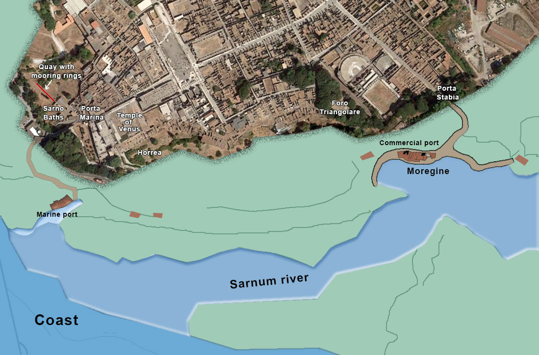
Notice the distinction between access to a port and a port inside the walls. People or goods arriving by water still had to move between landing places, roads, and city entrances. One particularly helpful landmark is the Marina Gate on the western side: its road led toward the sea. Its name and position express a connection, not proof that a vessel could dock at the gate.
A Guide to the Pompeii Excavations
Return to the Pompeii Sites guide to see how one city entrance connected the elevated settlement to the coastal approach.
Find “Marina Gate and walls” in Regio VII, printed p. 81. Begin at “Similar to a bastion perched on the edge of the plane” and read the gate description through its account of the two passages. Pay particular attention to where the gate opens and where its exit road led.
This gives you the first part of an urban map: the Sarno valley and bay outside the city, the plateau above them, and gates linking the two. Other gates connected Pompeii to inland settlements and roads. The walls defined an urban boundary, but they were also punctuated by points of movement.
Finding your way inside the walls
Now narrow the scale from landscape to streets. Pompeii had a network of intersecting routes and blocks. Its principal east–west street, Via dell’Abbondanza, ran from the area of the civic center toward the eastern side of the city. North–south streets crossed it. The layout is easier to remember as a set of connected landmarks than as a perfectly uniform grid: different parts of the city had their own histories and arrangements.
Three areas provide especially useful bearings:
- The Forum stood in the western part of the city. It was the principal civic square, bordered by buildings used for public, religious, and commercial life.
- The theatre quarter lay toward the southwest. It contained the Large Theatre and the smaller Odeon, with other public buildings nearby.
- The amphitheatre stood at the far eastern end of the city, beside the Large Palaestra, an open space associated with exercise. It was not next to the Forum: reaching it meant crossing a substantial part of Pompeii.
Read the site’s short descriptions of the Forum, a major street, and the theatre quarter. As you read, keep asking a spatial question: What route or neighboring feature helps locate this place?
Along the streets of Pompeii - Pompeii Sites
Read these selected passages from Pompeii Sites for a guided movement from the Forum, along a main street, and into the theatre quarter. They connect public buildings to routes rather than presenting them as isolated monuments.
Under “Forum,” read the Forum passage. Under “Fountain,” begin where the text identifies the street as the Decumanus Maximus and read the street passage. Finally, in the paragraph beginning “Here we are in the Theatre Quarter of Pompeii,” read the opening description. Focus on the Forum’s relationship to routes, the street’s direction, and the theatre quarter’s position within the city.
The Forum’s importance is not just that notable buildings surrounded it. It sat within a working network of streets and approaches. Via dell’Abbondanza helps orient you across the city; the theatre quarter reminds you that public activity was distributed, not concentrated in one square. At the eastern edge, the amphitheatre and Large Palaestra formed another major grouping of public space.
The gate names add an outer frame to this picture. Marina Gate was the western approach toward the sea; Herculaneum Gate connected with the road toward Herculaneum; other gates opened toward inland destinations. A route’s name is a clue to connection, although the routes and buildings visible today were not all created in one building campaign. Later in the course, that distinction will matter when you interpret changes to a street or building.
The volcano as landscape—and as archaeological event
Vesuvius was part of the setting long before the eruption. Volcanic activity helped form the ground on which Pompeii stood. Its presence also explains why the archaeological site exists in its extraordinary, buried form. These are two different relationships to the volcano: one concerns the landscape in which a city developed; the other concerns what happened to that city in AD 79.
Look again at the regional map. Pompeii’s position southeast of Vesuvius mattered during the eruption because wind carried substantial falling volcanic material in that direction. In this short clip, watch the map of deposit thickness rather than trying to memorize a single depth.
Exploring the Archaeological Site of Pompeii | with forensic expert Dr Estelle Lazer
Watch the opening geographical explanation in “Exploring the Archaeological Site of Pompeii,” presented by Academy Travel with Dr Estelle Lazer. It shows how Pompeii’s position relative to Vesuvius affected what fell on the site.
Watch the eruption map. Notice the direction of falling material and the contours showing deposit thickness across the bay. Also note the speaker’s warning that the volcano’s present shape is not identical to its ancient shape.
This is why a regional map is archaeologically useful, not merely introductory. Location helps explain which material accumulated over the city and why excavation must work through eruption deposits to reach its streets and buildings. It does not mean every object found beneath those deposits was left in place by the eruption, or that the map alone can tell us what happened in an individual house. Those questions require closer study of evidence and context later in the course.
A map to carry forward
You can now hold Pompeii at two scales. At the regional scale, place it southeast of Vesuvius, above the Sarno valley, with access to the Bay of Naples. At the urban scale, place the Forum in the west, the theatre quarter toward the southwest, Via dell’Abbondanza across the city, and the amphitheatre at the eastern end. Gates joined this enclosed city to roads, the river valley, and the coast.
The central lesson is that setting shaped opportunities and constraints; it did not dictate every feature of the city. Elevated ground, fertile surroundings, and connected routes help explain why Pompeii developed there. Changing coastlines and the AD 79 deposits also remind us that the landscape seen by archaeologists is not identical to the one Pompeii’s inhabitants knew.
Next, you will put the city’s major phases—from its ancient development through destruction, rediscovery, and excavation—into chronological order. That timeline will make the features you have located today easier to interpret as parts of a changing city.