Hello! Welcome back to our module on the Hydrosphere.
In our last lesson, we explored the hydrological cycle, the grand engine that moves water around the planet. We established that the ocean is the dominant player, with the vast majority of global evaporation and precipitation occurring over its surface. This continuous exchange of freshwater between the ocean and atmosphere is the perfect entry point for today's topic.
This lesson addresses the learning outcome: Describe the major factors influencing ocean salinity and temperature distribution. We will investigate why ocean water is not the same everywhere. We'll start by exploring salinity—what makes seawater salty and why its saltiness varies. Then, we'll examine the distribution of temperature. These two properties are the fundamental physical characteristics of seawater, and their variations are the key drivers of the global ocean circulation systems that regulate Earth's climate.
1. Ocean Salinity: The Saltiness of the Sea
You know the ocean is salty, but what does that mean chemically, and why isn't it equally salty everywhere?
What is Salinity?
Salinity is the measure of the total amount of dissolved salts in seawater. It is typically expressed in parts per thousand (ppt), which represents the number of grams of salt per 1000 grams (1 kilogram) of seawater. The average salinity of the world's oceans is about 35 ppt.
Let's begin by watching a short segment that defines salinity and explains how it is measured.
Ocean's Salinity Distribution | Halocline | Oceanography |Dr. Krishnanand
This video, 'Ocean's Salinity Distribution' by Dr. Krishnanand, provides an excellent foundation. We'll start with the basics of what salinity is and its measurement.
Watch from 00:35 to 03:00. Focus on the definition of salinity, the unit of measurement (ppt), and the average salinity of the oceans.
An interesting fact mentioned in the full video is the Principle of Constant Proportions. While the total amount of salt (salinity) varies from place to place, the relative proportions of the major dissolved ions (like sodium, chloride, sulfate, magnesium) remain remarkably constant throughout the ocean.
Where do these salts come from? The primary sources are:
- Chemical weathering of rocks on land: Rivers carry dissolved minerals from eroded rocks to the sea.
- Volcanic eruptions: Both on land and on the seafloor, volcanoes release gases and minerals into the water.
Factors Influencing Salinity
The key to understanding salinity distribution is to think of it as a balance between processes that remove freshwater (increasing salinity) and processes that add freshwater (decreasing salinity).

Let's break down these factors, which were introduced in the previous lesson as part of the hydrological cycle.
Distribution of Temperature and the Salinity in the Ocean
The article 'Distribution of Temperature and the Salinity in the Ocean' neatly organizes the factors affecting salinity into a table. This provides a structured overview.
Read the section titled 'Factors Affecting Distribution of Salinity of Ocean Water'. Pay attention to the inverse and direct relationships described for each factor.
To summarize, here is the balance:
| Increases Salinity (Removes Freshwater) | Decreases Salinity (Adds Freshwater) |
|---|---|
| Evaporation: When water evaporates, salts are left behind. | Precipitation: Rain and snow add freshwater directly to the ocean. |
| Formation of Sea Ice: When seawater freezes, the ice is mostly fresh, leaving the remaining unfrozen water saltier. | Runoff from Land: Rivers and streams carry freshwater into the ocean. |
| Melting of Ice: Melting glaciers, icebergs, and sea ice add freshwater. |
Spatial Distribution of Salinity
These factors create distinct patterns of salinity across the globe, both on the surface (horizontal distribution) and with depth (vertical distribution).
Horizontal Distribution (at the surface):
The distribution of salinity largely follows latitude, driven by the global balance of evaporation and precipitation.
The LibreTexts page 'Salinity Patterns' offers a clear explanation and an excellent map showing the latitudinal patterns of surface salinity.
Read the section 'Latitudinal Variations'. Study the map (Figure 5.3.2) and the text to understand why the highest salinity is not at the equator, but in the subtropics.
As you read, the key pattern to note is:
- Equatorial Regions: Have slightly lower salinity. Although evaporation is high due to intense solar radiation, it is outweighed by high rainfall from constant convectional storms.
- Subtropical Regions (around 20-30° N and S): Have the highest salinity. Here, you find the world's great deserts. The air is descending and dry, leading to high evaporation and very little rainfall.
- Polar Regions: Have low salinity. Evaporation is low, and the melting of sea ice and glaciers in the summer adds a significant amount of freshwater.
Vertical Distribution (with depth):
Salinity also changes as you go deeper into the ocean. The surface processes we've discussed mainly affect the upper layer of the ocean.
Ocean's Salinity Distribution | Halocline | Oceanography |Dr. Krishnanand
Let's return to the 'Ocean's Salinity Distribution' video to see how salinity changes with depth.
Watch the segment from 17:40 to 19:28. Focus on the definition of the halocline and the general trend of salinity with depth.
The key takeaways on vertical distribution are:
- Mixed Layer: The top 100-200 meters, where wind and waves create uniform salinity.
- Halocline: Below the mixed layer, there is a zone where salinity increases sharply with depth. This acts as a transition zone.
- Deep Ocean: Below the halocline, salinity is very stable and uniform, as it is isolated from the surface processes of precipitation, evaporation, and freezing.
Test your understanding!
Imagine two locations:
- The mouth of the Amazon River in South America.
- The central Red Sea, a narrow sea between North Africa and the Arabian Peninsula.
Which location would you expect to have higher surface salinity, and why? Refer to at least two factors that influence salinity.
Show answer
The Red Sea would have much higher surface salinity.
- Factor 1: Runoff: The Amazon River is the world's largest river by discharge volume, pouring enormous amounts of freshwater into the Atlantic, drastically lowering the salinity at its mouth. The Red Sea receives virtually no river runoff.
- Factor 2: Evaporation/Precipitation Balance: The Red Sea is in a hot, arid desert region with extremely high evaporation rates and very little precipitation. The Amazon basin, conversely, is in a tropical rainforest region with very high precipitation.
2. Ocean Temperature: The Warmth of the Sea
Like salinity, ocean temperature varies significantly across the globe and with depth. It is a critical factor influencing weather, climate, and marine life.
Factors Influencing Surface Temperature
The most important factor is insolation—the amount of solar radiation received at the surface. This creates a clear latitudinal pattern.
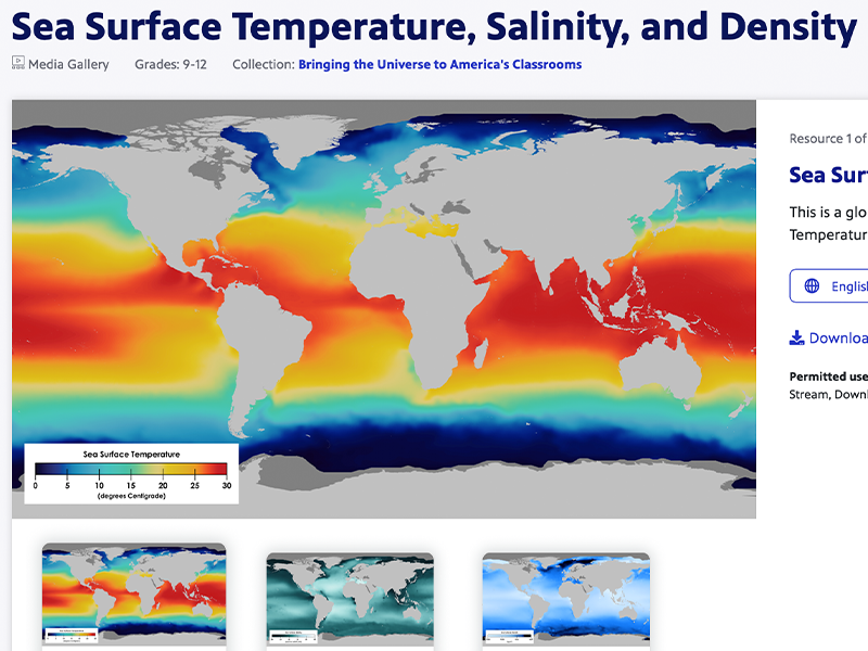
However, other factors modify this simple pattern.
Distribution of Temperature and the Salinity in the Ocean
This section of the NextIAS article outlines the key factors that influence ocean temperature, building upon the primary role of latitude.
Read the section 'Factors Affecting the Distribution of Temperature'. Focus on how ocean currents and prevailing winds can alter the expected temperature for a given latitude.
The key modifying factors are:
- Unequal Distribution of Land and Water: Land heats up and cools down faster than water. This leads to greater temperature extremes in the Northern Hemisphere, which has more landmass.
- Prevailing Winds: Winds can push warm surface water around. For example, winds blowing offshore can push surface water away from a coast, causing cold, nutrient-rich water from below to rise in a process called upwelling.
- Ocean Currents: Currents act like giant conveyor belts. Warm currents (e.g., the Gulf Stream) transport heat from the tropics towards the poles, warming regions like Western Europe. Cold currents (e.g., the Labrador Current) bring cold water from the poles towards the equator.
Vertical Distribution of Temperature
Just like salinity, temperature has a distinct vertical structure. You've already encountered the atmospheric layers; now let's explore the ocean's layers.
Temperature Variations with Depth
This short animated video, 'Temperature Variations with Depth', beautifully illustrates how the ocean's temperature profile changes with latitude.
Watch the entire video. Pay close attention to the shape of the temperature profile in polar, tropical, and temperate regions, and how the thermocline differs in each.
From the video, you can see the ocean is generally structured into three layers:
- Surface Mixed Layer (Top Layer): Warmed by the sun and mixed by winds and waves, this layer has relatively uniform temperature. Its thickness varies by latitude and season.
- Thermocline (Transition Layer): A zone of rapid temperature decrease with depth. It is a barrier that separates the warm surface water from the cold deep water.
- In the tropics, the thermocline is strong, permanent, and deep.
- In temperate regions, it is seasonal—strong in summer and weak or absent in winter.
- In polar regions, the water is cold from top to bottom, so there is no significant thermocline.
- Deep Zone (Bottom Layer): The water is uniformly cold, typically near freezing (around 0-3°C). This cold, dense water makes up about 80% of the entire ocean's volume.
Conclusion
In this lesson, you have learned about the two most fundamental physical properties of seawater: salinity and temperature. You can now describe the major factors that control their distribution across the world's oceans.
Key Takeaways:
- Salinity is a balance between freshwater removal (evaporation, ice formation) and freshwater addition (precipitation, runoff, ice melt). This creates a pattern of highest salinity in the subtropics and lower salinity at the equator and poles.
- Temperature is primarily controlled by solar radiation (latitude) but is significantly modified by ocean currents, winds, and the distribution of land.
- Both salinity and temperature have a distinct vertical structure. The halocline is a zone of rapid salinity change, while the thermocline is a zone of rapid temperature change.
- Below these transition zones, the deep ocean is remarkably uniform: it is cold, salty, and dense.
Preview of the Next Lesson:
Why did we study salinity and temperature together? Because together, they determine the density of seawater. Colder water is denser, and saltier water is denser. In our next lesson, "Analyze the major surface and deep-ocean current systems and the forces that drive them," we will see how these small differences in density, created by the patterns of heating and salinity we've just discussed, are powerful enough to drive massive, slow-moving currents in the deep ocean—a global conveyor belt that shapes our planet's climate system.