Hello! Welcome to our next lesson.
In our last session, we saw how spatial data is captured using GPS for precise point locations (vector data) and remote sensing for creating surface images (raster data). This raises a crucial question: how does a GIS take data referenced to the 3D, spherical Earth and display it accurately on your flat 2D computer screen? The answer lies at the heart of cartography and GIS.
Today's lesson addresses this fundamental challenge. Our goal is to distinguish between coordinate systems and map projections in a digital GIS environment. We will unravel some of the most important jargon in mapping—geoid, ellipsoid, datum, GCS, and PCS—to give you a clear, systematic understanding of how location is defined and represented in a GIS.
1. The Core Problem: A Round World on a Flat Screen
The Earth is not a perfect sphere. Due to variations in gravity and its rotation, its true shape is an irregular, lumpy object called a geoid. Imagine the shape the oceans would take if only influenced by gravity—that's a good approximation of the geoid.
This lumpy shape is too complex for simple mathematics. To create a usable coordinate grid (like latitude and longitude), cartographers use a simplified, smooth, mathematically defined shape called an ellipsoid or spheroid. It's an imperfect but necessary approximation of the geoid.
The next challenge is to anchor this mathematical ellipsoid to the real-world geoid. This is done using a datum. A datum defines the position and orientation of the ellipsoid relative to the Earth. Some datums, like the World Geodetic System 1984 (WGS 84), are designed to be a best-fit for the entire globe. Others, like the North American Datum 1983 (NAD 83), are optimized to fit a specific continent with higher accuracy.
To build a solid understanding of these foundational concepts, please watch the following video. It does an excellent job of explaining this progression from the lumpy geoid to the practical ellipsoid and datum.
Coordinate System Jargon: geoid, datum, projection
The video 'Coordinate System Jargon' by Rhumbline Studio clearly explains the concepts of the geoid, ellipsoid, and datum, which are the building blocks of any coordinate system.
Please watch from the beginning until 05:41. Focus on how the video explains: Why the complex geoid needs to be approximated by a simpler ellipsoid. What a datum is and why different datums exist (e.g., global WGS 84 vs. regional NAD 83).
With this foundation, we can now explore the two main types of coordinate systems used in GIS.
2. Geographic Coordinate Systems (GCS): Defining Where
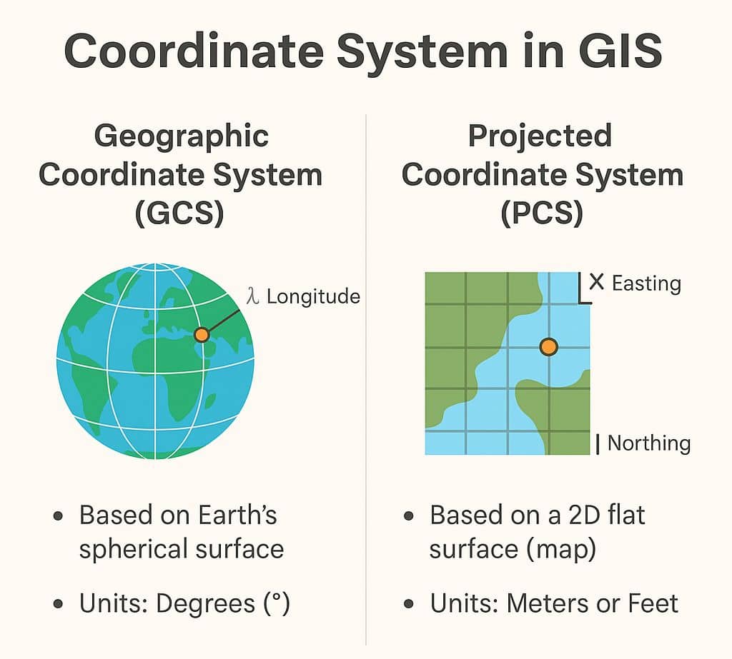
A Geographic Coordinate System (GCS) uses a three-dimensional model of the Earth (the ellipsoid) to define locations on the surface. It is the system that tells us where a feature is located on the globe.
A GCS has three key components:
- Datum: The chosen ellipsoid and its fit to the geoid (e.g., WGS 84).
- Angular Unit: The unit of measurement, which is almost always degrees.
- Prime Meridian: The line of zero longitude (e.g., the line passing through Greenwich, England).
The coordinates in a GCS are given as latitude and longitude. These are angles measured from the Earth's center to a point on its surface.
While a GCS is excellent for storing data and pinpointing absolute locations on the globe, it has a major drawback for mapping: the units (degrees) are not consistent. A degree of longitude at the Equator covers a much larger distance on the ground than a degree of longitude near the poles. This makes it impossible to accurately measure distances or areas directly from latitude and longitude values on a flat map.
3. Projected Coordinate Systems (PCS): Defining How to Draw
To overcome the measurement problem of a GCS, we need to transform our spherical coordinates onto a flat, 2D surface. This transformation process is called a map projection.
A Projected Coordinate System (PCS) is a flat, two-dimensional representation of Earth. It is defined on a GCS and is the result of applying a specific map projection. A PCS tells a GIS how to draw the data on a flat surface, like your screen.
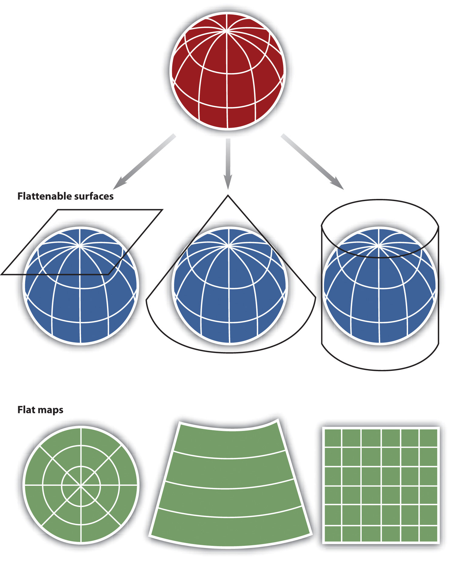
Because a PCS is flat, its coordinates are not angles. Instead, they are positions on a Cartesian grid (an X, Y grid), and their units are linear, such as meters or feet. These coordinates are often called Easting (the X-value) and Northing (the Y-value). Since the grid units are consistent everywhere on the map, a PCS is ideal for measuring distances, calculating areas, and performing other spatial analysis.
The most crucial point to remember is: Every Projected Coordinate System (PCS) must be based on a Geographic Coordinate System (GCS).
A PCS is built from these components:
- A base GCS (which itself includes a Datum).
- A specific Map Projection (the mathematical formula for flattening).
- Linear Units (e.g., meters).
- Parameters for the projection, like a Central Meridian or Standard Parallels, which define the center or lines of least distortion for the map.
The following reading provides an excellent and concise summary of this entire concept, using a simple but powerful analogy: GCS tells you where and PCS tells you how.
Geographic vs Projected Coordinate Systems
The ArcGIS Blog article 'Geographic vs Projected Coordinate Systems' is one of the clearest explanations available for beginners. It reinforces the key differences and explains their relationship.
Please read the entire article. Pay close attention to: The 'Where vs. How' analogy. The example showing how the same latitude/longitude coordinate can be in different physical places depending on the datum. The explanation of why a PCS is just a GCS that has been flattened. The final section that explains what happens when a GIS tries to draw a map using only a GCS (it must apply a default, often distorted, projection).
4. GCS vs. PCS: A Summary
Let's consolidate the key distinctions in a table. This is the core of today's learning outcome.
| Feature | Geographic Coordinate System (GCS) | Projected Coordinate System (PCS) |
|---|---|---|
| Purpose | Locating data on Earth's curved surface | Displaying and measuring data on a flat surface |
| Model | 3D (Ellipsoid/Spheroid) | 2D (Flat Plane/Cartesian Grid) |
| Units | Angular (Degrees, Minutes, Seconds) | Linear (Meters, Feet) |
| Coordinates | Latitude and Longitude | X and Y (Easting and Northing) |
| Best For | Storing data, global positioning | Analysis, measuring distance/area, mapping |
| Underlying Basis | Based on a Datum (e.g., WGS 84) | Based on a GCS + a Map Projection |
Test your understanding!
You are a GIS analyst for a city planning department. You have two main tasks:
- Create a highly accurate database of all property locations, which will be shared with federal agencies that use the global WGS 84 standard.
- Calculate the area of a new proposed park to see if it meets the minimum size requirement of 5,000 square meters.
For which task would you use a GCS, and for which would you use a PCS? Why?
Show answer
-
Task 1 (Database): You would store the data in a Geographic Coordinate System (GCS), specifically WGS 84. A GCS is ideal for storing and defining the absolute location of features on the globe and ensuring compatibility with a global standard.
-
Task 2 (Area Calculation): To calculate the area, you must use a Projected Coordinate System (PCS). A PCS uses linear units (like meters), which allows for accurate area and distance calculations. Trying to calculate area from the angular units of a GCS would give you a meaningless result. You would project your GCS data into an appropriate local PCS to perform the analysis.
5. Coordinate Systems in a Digital GIS Environment
Modern GIS software is designed to handle these complexities. A key feature is "on-the-fly" projection. This means you can add data layers to your map that are stored in different coordinate systems (some in GCS, some in various PCSs), and the GIS will automatically project them to match the coordinate system of your map view. This allows you to overlay data seamlessly, even if their underlying storage formats differ.
However, this is only for display. For analysis (like measuring area), you must ensure your data is in an appropriate PCS. Understanding the distinction is not just academic; it is essential for preventing major errors in your geographic analysis.
To see how all these components fit together, let's watch one final, short video clip.
GIS Coordinate Reference Systems
The video 'GIS Coordinate Reference Systems' by Q-tips provides a great summary of how a PCS is constructed from a GCS.
Please watch from 07:50 to 09:33. This clip perfectly summarizes the lesson by showing that a Projected Coordinate System is made of four things: an ellipsoid, a datum, a projection, and its parameters (like the line of tangency).
Conclusion
You've now navigated some of the most challenging but essential concepts in GIS. By understanding the journey from the real-world geoid to a practical projected coordinate system, you've unlocked the logic behind how all maps are made in a digital environment.
Key Takeaways:
- Geographic Coordinate Systems (GCS) use latitude and longitude on a 3D ellipsoid to define where a feature is. They use angular units (degrees) and are great for storing data but not for measuring on a flat map.
- Map Projections are the mathematical formulas used to convert a 3D GCS into a 2D plane. This process inevitably introduces distortion.
- Projected Coordinate Systems (PCS) are the 2D, flat result of a projection. They use linear units (meters/feet) and are essential for accurate measurement of distance and area on a map.
- In a GIS, every PCS is built upon a GCS. You can't have a PCS without first having a GCS to project.
Preview of the Next Lesson:
With a solid foundation in data models (vector/raster), data acquisition (GPS/remote sensing), and now coordinate systems, you are ready to start working with the data. In our next module, we will begin our journey into applied spatial analysis. The first lesson will focus on how to perform attribute and spatial queries to select and filter geographic data, the first step in asking questions of your map.