Hello. This module shifts from what district maps do to how they are made. Before judging whether a map produces an unusual partisan outcome, it helps to know who had authority to approve it and which rules limited their choices.
In this lesson, you will compare legislature-led redistricting with independent commissions. The central distinction is who has final map-approval authority, not merely who draws the first draft. Both arrangements must satisfy population and voting-rights requirements; geographic rules vary by state. Allow about 40 minutes for the lesson and its readings.
Who draws a map, and who approves it?
In a legislature-led process, lawmakers generally approve the map through the state's legislative process. A governor often has veto power, although that is not universal. Legislative staff, consultants, or another body might prepare a draft, but drafting a proposal is different from having the authority to enact it.
An independent commission, in the sense used here, is responsible for both drawing and approving the final map. Its members are selected through a process designed to separate that decision from current lawmakers and public officials. This changes who makes the final choice; it does not remove political stakes or guarantee a particular electoral outcome.
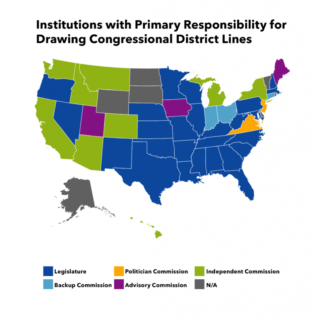
Two other arrangements show why the word commission alone is insufficient. An advisory commission proposes a map while the legislature retains final approval. A back-up commission takes over under specified conditions, such as a legislature's failure to adopt a plan. Commission membership, selection rules, and voting requirements also differ across states.
Who Draws the Maps? Legislative and Congressional Redistricting | Brennan Center for Justice
Read the Brennan Center for Justice's account to distinguish preparing a map from approving one. Treat its state counts as a snapshot, not a permanent tally.
At the opening of the article, just before “Advisory Commission,” read legislative approval. Then read advisory commissions under “Advisory Commission.” Under “Independent Commission,” read independent commissions. The following “Political Appointee Commission” and “Politician Commission” subsections illustrate why different bodies called commissions should not be treated as interchangeable.
The National Conference of State Legislatures uses a broader set of categories: commissions may have primary responsibility, advise legislatures, or serve as back-ups. Its account also makes the essential point that commissions and legislatures must comply with the same applicable legal standards.
Read the National Conference of State Legislatures' Chapter 5 to see how commission roles differ and why transferring mapmaking authority does not transfer it outside the law.
In Chapter 5, “Redistricting Commissions,” read from its opening explanation that legislatures remain responsible in most states through the commission categories. Focus on which body retains responsibility in each category, rather than memorizing how any one commission selects its members.
The map below illustrates variation in the institutions involved in drawing congressional lines. Use it as a visual guide to types of arrangements, not as a current inventory or a definitive guide to final approval: its categories describe primary drawing responsibility, and procedures can change.
A common population constraint
Whichever institution approves a map, it cannot assign vastly different numbers of people to equivalent districts. The principle often called one person, one vote requires districts within a state to meet an applicable population-equality standard.
For congressional districts, populations must be as nearly equal as possible. If a state has residents and five congressional districts, the ideal population is:
A mapmaker would work to bring each district extremely close to that figure. State legislative districts must be substantially equal, a less stringent standard that permits more flexibility while attending to other legitimate boundaries. The distinction concerns the office being districted, not whether lawmakers or commissioners hold the pen.
Chapter 2 explains why congressional and state legislative districts have different population-equality standards.
In Chapter 2, “Equal Population,” read the population account from the historical explanation through the final comparison with state legislative districts. Pay particular attention to “as nearly equal as possible” versus “substantially equal.”
Population equality narrows the available choices, but it seldom determines one unique map. Many different boundaries can place approximately the required number of people in each district. That remaining room for choice is why institutions and other criteria matter.
Geographic rules narrow the choices further
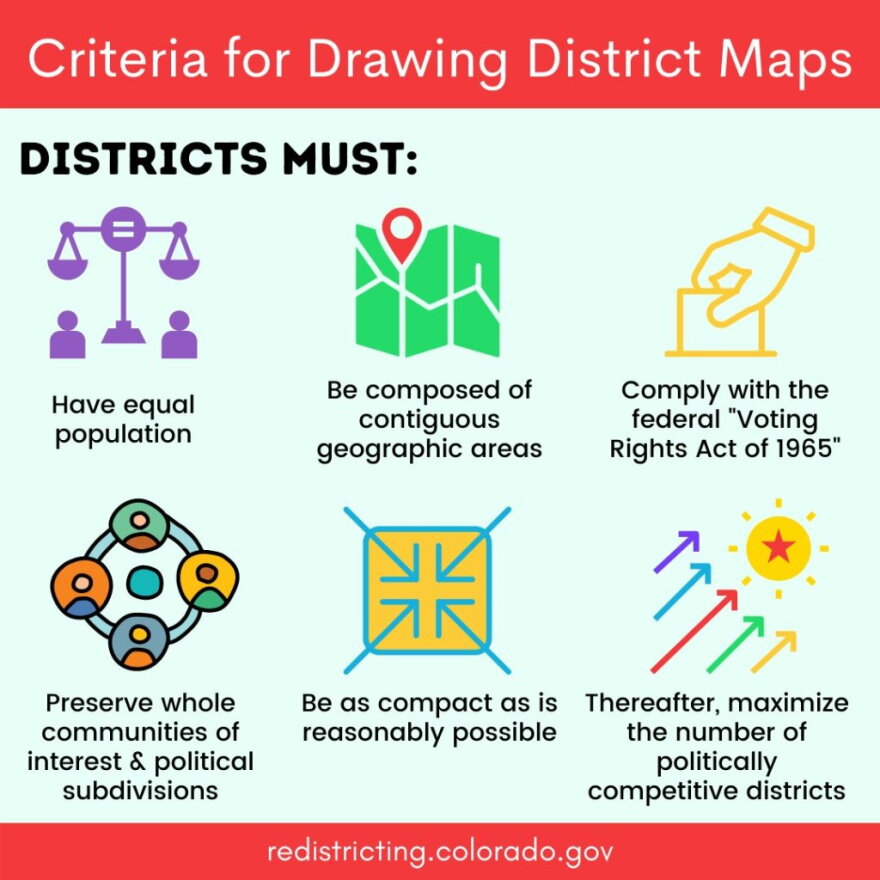
States also set geographic criteria for districts. Common examples include contiguity—a district forming one connected geographic area—compactness, and efforts to preserve political subdivisions or communities of interest. A community of interest might be a group with shared local concerns that a state seeks to keep together for representation; its precise treatment depends on the state's rules.
These considerations can conflict. Keeping a town intact may make a district less compact; achieving close population equality may require crossing a county boundary. Some states specify priorities among their criteria. Neither a legislature nor a commission gets to disregard rules simply because another map would produce a preferred seat count.
Chapter 4 separates broadly applicable federal requirements from additional criteria supplied by states.
In Chapter 4, “Redistricting Principles and Criteria,” read the state criteria through the end of the chapter's brief account. Notice both the examples of geographic criteria and the warning that they can conflict.
This graphic offers one state's way of arranging map-drawing priorities. Its top row highlights population, contiguity, and voting rights; its lower row includes preserving communities, compactness, and then seeking competitive districts. Do not read every item as an identical nationwide legal requirement. In particular, maximizing competitive districts is not a general federal requirement, and the force and priority of geographic criteria depend on state law.
Voting rights constrain both kinds of mapmaker
Population equality asks whether people are distributed comparably in number. Voting-rights law asks a different question: whether a districting plan unlawfully impairs representation on grounds such as race. The Voting Rights Act's Section 2 addresses racial vote dilution, which can involve minority voters being dispersed across districts or excessively concentrated. Equal-population districts can still raise a voting-rights problem.
The Constitution also constrains racial sorting in districting. These obligations apply whether the map is approved by legislators or by an independent commission. They do not mean that every district with a concentrated racial minority is unlawful, or that a mapmaker must ignore race when assessing compliance. The detailed legal tests—and the distinction between a vote-dilution claim and a racial-gerrymandering claim—belong to the later legal module. For now, the institutional lesson is that changing the decision-maker does not eliminate either obligation.
Read Chapter 3 for the basic voting-rights constraints that apply regardless of who approves a map. This is an overview, not the final word on the detailed legal tests examined later in the course.
In Chapter 3, “Racial and Language Minorities,” read the VRA overview, covering its discussion of vote dilution and the following paragraph on racial gerrymandering. Stop before the paragraph beginning “Section 5 of the VRA required”; that historical preclearance discussion is not needed for this comparison.
Putting institution and constraint together
Imagine two states each preparing a congressional map after a census. In one, the legislature approves a plan, ordinarily through legislative votes and whatever gubernatorial role that state provides. In the other, an independent commission draws and approves the plan under its governing procedures. The final decision-maker differs; the baseline obligations do not. Both must meet congressional population-equality requirements and applicable voting-rights law. Each must also follow its own state's geographic and other map-drawing rules.
An independent commission can change the incentives and bargaining around a map by moving final approval away from incumbent lawmakers. That is an institutional distinction, not a shortcut to judging the finished map. To evaluate a particular plan, you would still need to examine its constraints and consequences. The next lesson takes up one consequence that can arise even without deliberate partisan manipulation: how residential clustering affects the districts a map can create.
The key takeaway is to keep three questions separate: Who drafts the map? Who has final authority to approve it? What rules bind that authority? Answering all three gives you a sound starting point for comparing redistricting systems.