Hello! Welcome to the start of our final module, "Advanced Applications and Geographical Customization."
In our last lesson, we concluded our study of the six classical seasons by examining Makar Sankranti. We established it as the astronomical transition from the strength-building Dakshinayana to the strength-depleting Uttarayana, a pivot point governed by the Sun's southern and northern journey. This entire framework, however, is based on observations from the Indian subcontinent.
Today, we take our first step towards a global application of Ritucharya. To adapt these principles for a client in London, Tokyo, or Sydney, we must first go back to the source: the Sun. Our learning outcome is to analyze how geographical latitude alters the astronomical parameters (e.g., day length, solar angle) that define the Ritus.
This lesson will provide the fundamental astronomical 'why' behind the different seasonal experiences around the globe. By understanding how the Sun's energy is delivered differently to various parts of the Earth, you will be equipped to deduce, not just memorize, how to adjust Ritucharya for any location.
The Engine of Seasons: A Refresher on Axial Tilt
As we've discussed, the entire rhythm of Uttarayana and Dakshinayana is driven by one simple fact: the Earth's axis of rotation is tilted by approximately 23.5 degrees relative to its orbital plane around the Sun. This tilt remains constant as the Earth orbits the Sun.
To refresh this core concept, please watch the following video. It provides a clear, visual explanation of how this tilt is the fundamental cause of seasons.
The video 'Why does Earth have Seasons?' offers a simple yet effective visualization of how the Earth's constant axial tilt leads to seasonal changes as it orbits the Sun.
Please watch from 05:18 to 10:07. Focus on these key points: The concept of the constant axial tilt (05:18 - 06:37). How this tilt results in direct vs. indirect sunlight (06:37 - 08:01). How this creates opposite seasons in the Northern and Southern Hemispheres (08:01 - 10:07).
This constant tilt is the engine. Everything we discuss next is a direct consequence of it.
The Two Pillars of Solar Influence
From an Ayurvedic perspective, the Sun is the primary source of Tejas, manifesting as the Ushna (hot) and Ruksha (dry) Gunas that are characteristic of Adana Kala. The intensity of this influence at any place on Earth is determined by two primary astronomical parameters:
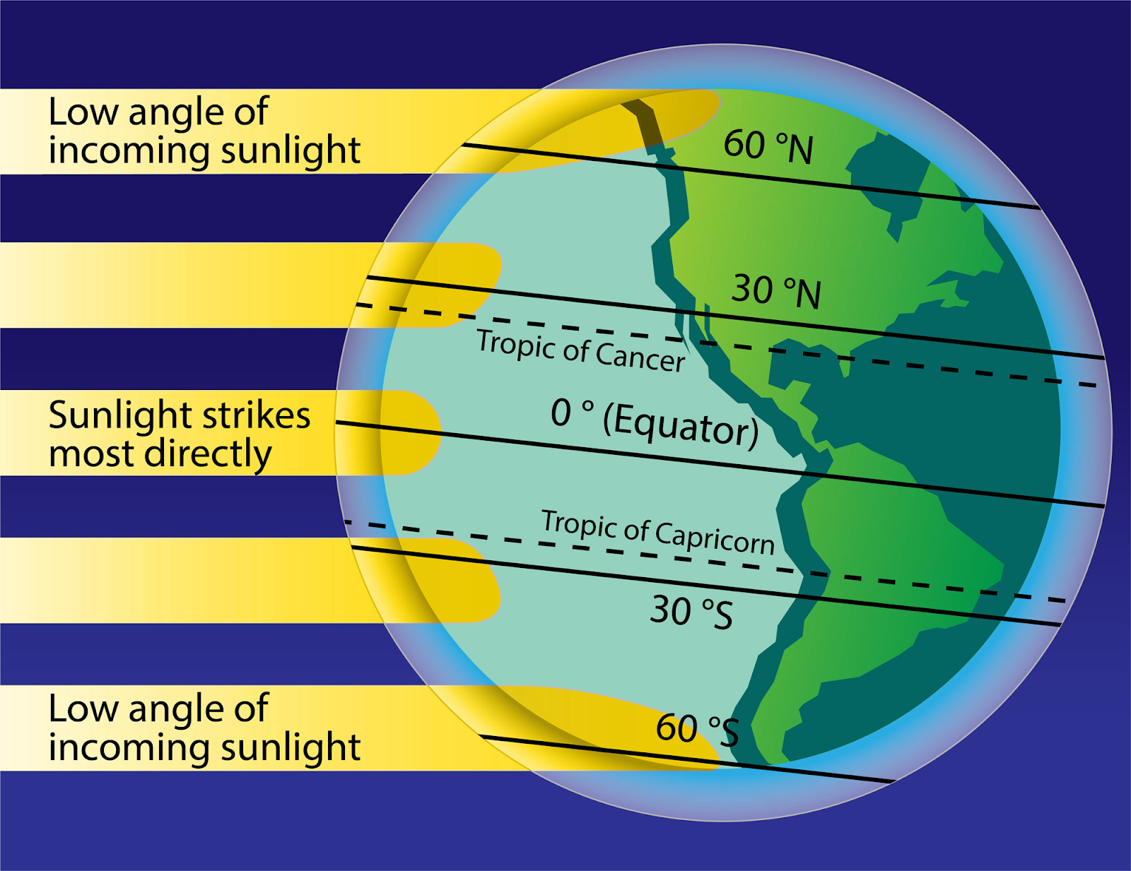
- Solar Angle (Intensity): This refers to how directly the Sun's rays strike the Earth. When the Sun is high in the sky (a high solar angle), the energy is concentrated over a small area, leading to greater intensity and heating. When the Sun is low in the sky (a low solar angle), the same energy is spread over a larger area, making it less intense.
- Day Length (Duration): This is simply the amount of time the Sun is above the horizon. A longer day means more hours of solar heating.
To truly understand how seasons work, it's crucial to grasp that both factors work together. The following resource explains this relationship clearly.
4.2 The Seasons – BCIT Astronomy 7000: A Survey of ...
The article 'The Seasons' provides a foundational explanation of how both solar angle and day length contribute to seasonal temperature changes.
Please read the first section titled 'The Seasons and Sunshine'. Pay close attention to the two effects it describes: the angle of sunlight (illustrated by the flashlight analogy and the 'Sun's Rays in Summer and Winter' diagram) and the length of time the sun is above the horizon.
Latitude: The Master Variable
Now we come to the core of today's lesson. Geographical latitude is the measure of how far north or south a location is from the Earth's equator. This single variable is what determines the specific pattern of solar angle and day length a location experiences throughout the year.
Let's break this down by looking at three distinct zones.
1. The Tropics (Low Latitudes: ~23.5° N to 23.5° S)
This zone includes the equator (0° latitude). Here, the seasonal variations are minimal.
- Day Length: Stays close to 12 hours all year round.
- Solar Angle: The Sun is always high in the sky at noon.
- Result: The total solar energy received is high and relatively constant. This is why these regions don't have the temperature-driven "hot" and "cold" seasons of the classical Ritucharya model. Instead, their seasons are often defined by rainfall patterns (wet and dry seasons), which are a secondary atmospheric effect.
2. The Mid-Latitudes (Temperate Zones: ~23.5° to 66.5° N and S)
This is where India, Europe, North America, and much of the world's population resides. The classical Shad Ritu and the four-season model are most applicable here.
- Day Length: Varies significantly between summer (long days) and winter (short days).
- Solar Angle: Varies significantly between summer (high noon sun) and winter (low noon sun).
- Result: The combination of long days and direct sun in summer leads to high heat. The combination of short days and indirect sun in winter leads to significant cold. The further you move from the equator within this zone, the more extreme these differences become.

3. The Polar Regions (High Latitudes: ~66.5° to 90° N and S)
This zone lies beyond the Arctic and Antarctic Circles.
- Day Length: The variation is extreme, leading to 24-hour daylight in summer ("midnight sun") and 24-hour darkness in winter.
- Solar Angle: Even during the 24-hour daylight of summer, the Sun is always low in the sky, circling the horizon.
- Result: Because the solar angle is always low, the intensity of sunlight is weak. This is why the polar regions remain cold even with constant summer daylight.
The following image provides a simple but powerful illustration of how the Sun's energy is distributed based on latitude.
To solidify this understanding, let's turn to a more detailed reading that connects these zones to specific astronomical markers.
4.2 The Seasons / The Sun from Different Latitudes
This section of 'The Seasons' article, along with a similar one from another resource, explicitly discusses how seasons differ at various latitudes. They introduce key geographical lines as astronomical definitions.
First, read the section 'The Seasons at Different Latitudes' from the article 'The Seasons'. This will give you a narrative overview of the differences between the equator and the poles.
Understanding Astronomy: The Sun and the Seasons
Now, let's read a complementary text that defines the key latitudinal zones—Tropics, Temperate, and Arctic/Antarctic—based on the Sun's behavior.
Please read the section 'The Sun from Different Latitudes'. It clearly defines the Tropic of Cancer, Tropic of Capricorn, and the Arctic/Antarctic Circles in terms of what an observer at that latitude sees the Sun do on the solstices.
Test your understanding!
Imagine two patients celebrating the summer solstice on June 21st. One is in Chennai, India (~13° N latitude), and the other is in Stockholm, Sweden (~59° N latitude).
Describe how their experience of the "longest day of the year" would be different in terms of both day length and noon solar angle. Which location receives more intense solar energy?
Show answer
- Day Length: The Stockholm patient would experience a much longer day, close to 18.5 hours of daylight, with a very long twilight. The Chennai patient's day would be significantly shorter, around 13 hours. The effect of latitude on day length becomes more pronounced as you move towards the poles.
- Noon Solar Angle: The situation is reversed for solar angle. On June 21st, the Sun is at its northernmost point (23.5° N). Chennai (13° N) is very close to this latitude, so the Sun will be almost directly overhead at noon, at a very high angle. Stockholm (59° N) is much farther north, so even at noon on the longest day, the Sun will be at a much lower angle in the sky.
- Intensity: Chennai receives far more intense solar energy because of the high solar angle, even though the duration of daylight is shorter. This demonstrates the critical difference between duration and intensity.
A Glimpse into the Calculations
While a deep dive into trigonometry is beyond our scope, it's valuable to know that these parameters are not mysterious; they are precisely calculable. The angle of the Sun at noon can be determined for any latitude on any given day.
The video below explains the simple steps involved. As you watch, focus on the logic of the process rather than memorizing the formula. Understanding the components of the calculation—your latitude, the date, and the Sun's position—is what matters.
The video 'Calculating Noon Sun Angle' walks through the logic of how to determine the Sun's angle for any location and date.
Please watch from 03:59 to 07:31. The first part (from 03:59) outlines the five conceptual steps. The second part (from 04:45) applies these steps to a real-world example. Notice how the calculation is essentially about finding the distance in degrees of latitude between the observer and the point on Earth where the Sun is directly overhead.
This predictable, geometric relationship between latitude and solar energy is the foundation upon which we can build a truly global and personalized Ritucharya.
Conclusion
Today, we have established the astronomical principles that govern seasonal variations across the globe. By moving beyond a single geographical context, we can now see the Ritus not as a fixed schedule, but as a dynamic response to the changing delivery of solar energy.
Key Takeaways:
- The Earth's 23.5° axial tilt is the fundamental cause of all seasons.
- The two key astronomical parameters that define a season's character are solar angle (intensity) and day length (duration).
- Geographical latitude is the master variable that determines how these two parameters change throughout the year.
- Low latitudes (Tropics): Experience high, constant solar energy, with minimal variation in day length or solar angle.
- Mid-latitudes (Temperate): Experience significant variations in both day length and solar angle, leading to pronounced seasons.
- High latitudes (Polar): Experience extreme variations in day length but an always-low solar angle, leading to cold climates.
Preview of the Next Lesson:
We have just learned how the astronomical parameters change with latitude. The next logical question is, "What does this mean for Dosha management?" In our next lesson, we will begin the practical work of mapping the climatic characteristics of a given non-tropical region (e.g., Europe, North America) to the Dosha and Guna framework. We will translate today's astronomical facts into tangible Ayurvedic insights.